
Displaying items by tag: Earth observation
ICESat
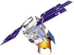
ICESat (Ice, Cloud, and land Elevation Satellite), part of NASA's Earth Observing System, was a satellite mission for measuring ice sheet mass balance, cloud and aerosol heights, as well as land topography and vegetation characteristics.
ICESat was launched 13 January 2003 on a Delta II rocket from Vandenberg Air Force Base in California into a near-circular, near-polar orbit with an altitude of approximately 600 km.
It operated for seven years before being retired in February 2010, after its scientific payload shut down and scientists were unable to restart it.
The ICESat mission was designed to provide elevation data needed to determine ice sheet mass balance as well as cloud property information, especially for stratospheric clouds common over polar areas. It provides topography and vegetation data around the globe, in addition to the polar-specific coverage over the Greenland and Antarctic ice sheets. The satellite was found useful in assessing important forest characteristics, including tree density.
OHB SE

OHB SE is a spaceflight company located in Bremen, northern Germany,
(OHB stands for "Orbitale Hochtechnologie Bremen" - Orbital High-technology Bremen)
Domiciled in Bremen, OHB SE (ISIN: DE0005936124, Prime Standard) is Germany’s first listed space and technology company. Two business units offer international customers sophisticated solutions and systems.
With over 39 years of experience in high technology together with its integrated skills in the areas of space technology and telematics, OHB Group is ideally positioned as one of the leading independent forces in the European space, aeronautics and telematics industry.
SPACE SYSTEMS
This business unit’s activities encompass satellites, manned spaceflight, exploration and security/reconnaissance technologies. Another focus is developing and implementing payloads, scientific equipment and devices for aeronautics/aerospace, research institutes and industry. Thus, OHB System AG develops, builds, launches and operates low-orbiting and geostationary small satellites for scientific applications, communications and terrestrial observation.
AEROSPACE
The „Aerospace" corporate division places emphasis on the manufacturing of products for aviation and space travel. In this regard, OHB has positioned itself as a significant equipment provider for aerospace structures for aviation and space travel and, amongst others, is Germany's largest supplier to the Ariane 5 programme and an established manufacturer of sensitive components made of highly heat resistant nickel based alloys and titanium for aircraft engines.
DIGITAL
The OHB Digital business unit leverages direct space capabilities and ensures the transfer of technology to selected industries.
Helios 2 (military surveillance satellite)
Helios II is a military satellite for Earth observation. It is operating since April 2005.
It is operated jointly by France, Belgium, Spain, Greece and Italy.
Ziyuan 3
Ziyuan 3 or ZY-3 (Chinese: 资源三号 meaning Resources 3) is a Chinese Earth observation satellite launched in January 2012. It is a high-resolution imaging satellite operated by the Ministry of Land and Resources of the People's Republic of China.
The Ziyuan 3 satellite was constructed by the China's Academy of Space Technology, and carries three cameras produced by the Changchun Institute of Optics, Fine Machinery and Physics. A camera aligned normal to the Earth's surface will produce images with a spectral resolution of 2.5 metres (8 ft 2 in), whilst the other two, offset at 22 degrees forward and aft, have spectral resolutions of 4.0 metres (13.1 ft). In addition to the three cameras, Ziyuan-3 carries an infrared multispectral spectrometer, with a spectral resolution of 6.0 metres (19.7 ft). The satellite is used to provide imagery to monitor resources, land use and ecology, and for use in urban planning and disaster management. It had a mass at launch of 2,630 kilograms (5,800 lb).
Ziyuan 3 was launched by a Long March 4B carrier rocket, flying from Launch Complex 9 at the Taiyuan Satellite Launch Centre. The launch occurred at 03:17 UTC on 9 January 2012, and was the first orbital launch of the year. VesselSat-2 was launched as a secondary payload on the same rocket.
ref: CASC website news
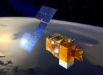
EPS-SG (programme)

EPS is a programme of Earth observation for Meteorology and weather forecast. The satellite is called METOP. EPS/METOP is managed by the European organisation EUMETSAT. Placed on a polar orbit, the satellite sends picture of the whole Earth.
EPS-SG is the Second Generation of this programme. (respectively the satellite is METOP-SG)
Activities are on-going (Aug. 2012) for the definition of the follow-on EUMETSAT Polar System, to replace the current satellite system in the 2020 timeframe and contribute to the Joint Polar System to be set up with NOAA. Through consultation with users and application experts, requirements have been defined for a range of candidate missions mainly in support of operational meteorology and climate monitoring. A number of on-board instruments, satellite platforms and ground support infrastructure are under study in coordination with ESA, NOAA, DLR and CNES. The satellites will fly, like Metop, in a sun synchronous, low earth orbit at 817 km altitude and 09:30 local time of the descending node, providing observations over the full globe with revisit times of 12 to 24 hours, depending on instrument. Feasibility studies are on-going with the main objective to define the baseline configuration for subsequent detailed design, development and operation programmes to be proposed and coordinated within the involved organisations. Started in 2005 under the name of Post-EPS, the activities will enter in 2012 the design and development phases under a new programme: EPS Second Generation (EPS-SG).
EnerGEO

Earth observation for monitoring and assessment of the environmental impact of energy use.
The EnerGEO project consists of 12 partners from 6 countries and has a duration of 4 years. The project started 1November 2009
MacDonald, Dettwiler & Associates Ltd (MDA)

MacDonald, Dettwiler & Associates Ltd (MDA) is a Canadian aerospace, information services and products company, employing over 3000 people throughout Canada, the United States and the United Kingdom, under the MDA brand name.
It is headquarted in Richmond, British Columbia, Canada.
MDA provides commercial customers, industrial partners and governments (civil, defense, security, space, and R&D agencies) with information systems and solutions like:
- Space robotics, satellite, and payload systems;
- Earth observation, airborne, surveillance, intelligence, and environmental monitoring;
- Radar and optical satellite imagery, and remote sensing;
- Mapping products.
Surrey Satellite Technology - SSTL

Surrey Satellite Technology Ltd, or SSTL, is a spin-off company of the University of Surrey, now (July 2012) fully owned by EADS Astrium, that builds and operates small satellites.
Its satellites began as amateur radio satellites known by the UoSAT (University of Surrey SATELLITE) name, or by an OSCAR (Orbital Satellite Carrying Amateur Radio) designation. SSTL cooperates with the University's Surrey Space Centre, which does research into satellite and space topics.
SSTL has moved into remote sensing services with the launch of the Disaster Monitoring Constellation (DMC) and an associated child company, DMC International Imaging. SSTL also adopted the Internet Protocol for the DMC satellites it builds and operates, migrating from use of the AX.25 protocol popular in amateur radio. The CLEO Cisco router in Low Earth Orbit, on board the UK-DMC satellite along with a network of payloads, takes advantage of this adoption of the Internet Protocol. The UK-DMC satellite also carries a payload investigating GPS reflectometry.
RapidEye AG

RapidEye AG was a German geospatial information provider focused on assisting in management decision-making through services based on their own Earth observation imagery. The company owns a five satellite constellation producing 5 meter resolution imagery that was designed and implemented by MacDonald Dettwiler (MDA) of Richmond, Canada. Originally located in Munich, the company relocated 60 km southwest of Berlin to Brandenburg an der Havel in 2004.
Applications
RapidEye provides geospatial information-based management solutions to the following industries: agriculture, forestry, environment, spatial solutions.
Satellites
Five Identical Satellites: Built by Surrey Satellite Technology Ltd. (SSTL) of Guildford, subcontracted by MacDonald Dettwiler (MDA). Each satellite is based on an evolution of the flight-proven SSTL-100 bus, and measures less than one cubic meter and weighs 150 kg (bus + payload).
On November 6, 2013 RapidEye has officially changed its name to BlackBridge.
SPOT Image
Spot Image is a French public limited company created in 1982 by the French Space Agency, Centre National d'Etudes Spatiales (CNES), the IGN, and Space Manufacturers (Matra, Alcatel, SSC, etc.). It is now (year 2012) a subsidiary of EADS Astrium (99%).
The company is the commercial operator for the SPOT Earth observation satellites.
Spot Image is a worldwide distributor of products and services using imagery from Earth observation satellites and works through a network of subsidiaries, local offices (Australia, Brazil, China, United States, Japan, Peru, Singapore), and partners. The goal is to provide on-the-spot service with worldwide availability.
Spot Image works with a network of more than 30 direct receiving stations handling images acquired by the SPOT satellites.