
Displaying items by tag: Earth observation
Canopus Systems US

Canopus Systems US, LLC, is an American company developping the Perseus constellation of Earth observation satellites.
Perseus will provide high quality imagery of the entire Earth, everyday, from a light CubeSat platform, offering imagery at an affordable price, making the data widely accessible. To bridge the data availability barrier, current and archived data will be available to all via a cloud based platform that encourages value added application development in addition to direct imagery access.
The Perseus constellation will utilize the CubeSat standard for cost-effective access to space as secondary payloads to larger, much more expensive Earth observing spacecraft. Traditional Sun-synchronous Earth observation orbits provide constant lighting conditions for data continuity through time. Synchronization of this constellation allows imagery of the entire Earth daily, which is something a traditional spacecraft would be incapable of doing, at a lower cost than one traditional spacecraft.
Planet Labs Inc.
Planet Labs Inc. is an American company with the aim to provide universal access to information about the changing planet.
We will operate the world's largest fleet of Earth imaging satellites to frequently image the entire planet and provide open access to that information.
We build space platforms using state-of-the-art technology. We design and build the satellites in San Francisco; we test the capabilities in the lab, on mountaintops, from airplanes and in space:
- the Dove Series of Satellites.
- FLOCK 1: In early 2014, Planet Labs will launch the world's largest constellation of Earth observing satellites.
ECMWF - European Centre for Medium-Range Weather Forecasts

The European Centre for Medium-Range Weather Forecasts (ECMWF) is an independent intergovernmental organisation supported by 34 states.
ECMWF is both a research institute and a 24/7 operational service, producing and disseminating numerical weather predictions to its Member States. This data is fully available to the national meteorological services in the Member States. The Centre also offers a catalogue of forecast data that can be purchased by businesses worldwide and other commercial customers. The supercomputer facility (and associated data archive) at ECMWF is one of the largest of its type in Europe and Member States can use 25% of its capacity for their own purposes.
National Remote Sensing Center of China (NRSCC)

The National Remote Sensing Center of China (NRSCC) is the Chinese organisation in charge of Earth Observation.
Its main functions:
- to provide recommendations and solutions to the development strategy, planning and overall policy decision of remote sensing technology and its industrialization for MOST by studying the status, trends and challenges;
- to operate the remote sensing services to the General Office of State Council (GOSC) on information about disasters, agriculture, ecology and environment etc.;
- to implement projects on remote sensing and space information technology under various national R&D programs of China, such as National High Technology Research and Development Program (863 Program), National Key Technology R&D Program and Mega-Projects of Science Research, as trusted by of MOST, and to promote industrialization of relevant results;
- to organize and coordinate the implementation of China-Europe Cooperation Project on Galileo;
- to participate in the formulation, assessment and accreditation of related national standards, norms and regulations in earth observation and navigation technology;
- to promote and organize multilateral and bilateral international cooperation projects, and to organize related training and personnel exchange activities; to act as the contacting point of the China-European GNSS Technology Training and Cooperation Center;
- to host the China Secretariat of the Committee on Earth Observation Satellites (CEOS) , China Secretariat of the Group on Earth Observations (GEO), and act as the national focal point of the United Nations Regional Space Applications Program for Sustainable Development in Asia and the Pacific (RESAP);
- to liaise with remote sensing institutes in China, to provide technical training and consultancy services.
The technical fields of NRSCC have been extended from remote sensing and geographic information system to the domain of earth observation and navigation technology, including remote sensing, geographic information system, satellite navigation and positioning, and deep space exploration. Its overall function is to organize and implement national scientific and technological plans in the field of earth observation and navigation technology. It aims at developing innovation capacity of China and fostering the strategic new industry in remote sensing, geographic information system and navigation and positioning. It is characterized by the international cooperation and the national strengths by mode of "condensed kernel, wide network". NRSCC also provides the technical support to major strategic decisions for the national economic construction, social sustainable development by exerting the advantages of remote sensing science and technology.
United States Geological Survey (USGS)

The United States Geological Survey (USGS) is a scientific agency of the United States government. The scientists of the USGS study the landscape of the United States, its natural resources, and the natural hazards that threaten it.
The organization has four major science disciplines, concerning biology, geography, geology, and hydrology. The USGS is a fact-finding research organization with no regulatory responsibility. The USGS employs approximately 8,600 people and is headquartered in Reston, Virginia, USA. The USGS also has major offices near Lakewood, Colorado, at the Denver Federal Center, and Menlo Park, California.
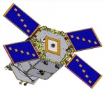
EPS (EUMETSAT Polar System)
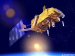
The EUMETSAT Polar System (EPS) is a European satellite system that offers remote sensing capabilities to both meteorologists and climatologists. It consists of a series of three polar orbiting Metop satellites, to be flown successively for more than 14 years, from 2006, together with the relevant ground facilities.
The satellites form the space segment component of the overall EPS system, which in turn is the European half of the EUMETSAT/NOAA Initial Joint Polar System (IJPS).
Metop-A (launched on 19 October 2006) and Metop-B (launched on 17 September 2012) are in a lower polar orbit, at an altitude of 817 kilometres, to provide more detailed observations of the global atmosphere, oceans and continents. The two satellites will operate in parallel for as long as Metop-A's available capacities bring benefits to users. Metop-C is due to be launched in 2017.
EPS Programme Background
EUMETSAT is responsible for coordinating all elements of the development, launch and operation of EPS satellites. This includes developing and procuring the ground segment; procuring the launcher and launch site, and operating the systems. Under the IJPS and Joint Transition Activities (JTA) agreement, EUMETSAT and NOAA have agreed to provide instruments for each other's satellites; exchange all data in real time, and assist each other with backup services. Other partners are European Space Agency and CNES.
The European and American satellites carry a set of identical sensors:
AVHRR/3 and the ATOVS suite consisting of AMSU-A, HIRS/4 and MHS. NOAA provides most of the joint instruments on board the satellites and EUMETSAT has developed and provides NOAA with the Microwave Humidity Sounder (MHS).
In addition, the Metop satellites carry a set of European sensors, IASI, ASCAT, GOME-2 and GRAS, aimed at improving atmospheric soundings, as well as measuring atmospheric ozone and near-surface wind vectors over the ocean. They also carry the Argos Advanced Data Collection System (A-DCS).
Global Precipitation Measurement satellite (GPM)
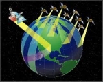
Global Precipitation Measurement is a joint mission between JAXA and NASA as well as other international agencies to frequently (every 3 hours) measure the Earth's atmospheric moisture.
It is part of NASA's Earth Systematic Missions program and is planned to cover nearly the complete Earth. The project office is overseen by NASA's Goddard Spaceflight Center and will provide global rain maps to assist researchers in studying global climate data.
The mission consists of a multiple spacecraft. The core spacecraft, used to measure precipitation structure and to provide a calibration standard for the constellation spacecraft, is scheduled for launch on July 21, 2013 and the low-inclination spacecraft for launch in November 2014 which will provide frequent precipitation measurements on a global basis.
SpaceEye-1 satellite system
SpaceEye-1 is a 300 kg class small satellite system for Earth observation mission, providing 1 m level resolution images which only large satellites have generated so far.
SpaceEye-1 is designed for enabling customers to acquire the state-of-the-art small Earth observation satellite at a fraction of the conventional satellite cost and benefit from low launch cost. Its qualification model is currently under development.
SpaceEye-1 and its companion products, SpaceEye-2 and SpaceEye-10, are proposed by the satellite manufacturer Satrec Initiative.
NGI project

The NGI project (Near Real-Time Geo-annotated Imagery) is an imaging system for near real-time satellite imagery delivery services. The target is to provide rapidly access to GIS-ready imagery within 10 minutes of transmission to ground.
Leading the NGI project, Spacemetric is coordinating an experienced team from Sweden and the UK that will develop and demonstrate the new technologies during the 18-month project. Partners SSC and Metria bring a wealth of experience from ground station operations and satellite image value-adding respectively.
At the same time, Magellium Ltd brings in-depth experience from satellite mapping systems developed by its parent for French Government agencies.
The project is financed within ESA's GSTP programme and is expected to provide service solutions of high interest in a range of application areas including rapid mapping and media. Use of open service standards, such as OGC, is an important element of the project strategy along with the use of Spacemetric's Keystone Image Management System as a COTS to jump-start the technical development work.
PRISMA-I
The PRISMA satellite (PRecursore Iperspettrale della Missione Applicativa, i.e: Hyperspectral Precursor of the Application Mission) is an Earth observation system by the Italian Space Agency (ASI) with innovative electro-optical instrumentation which combines a hyperspectral sensor with a panchromatic, medium-resolution camera. It is a follow-on project for the cancelled HypSEO mission.
The advantages of this combination are that in addition to the usual capability of observation based on recognising the geometric characteristics of the scene there are hyperspectral sensors which determine the chemical-physical composition of the objects present on the scene.
This offers the scientific community and users many applications in the field of environmental monitoring, resource management, crop classification, pollution control and other things. In addition, there may be other applications in the field of National Security.