LSTM is a next generation ESA mission within the Copernicus program to complement Sentinel observation capabilities with high spatio-temporal resolution TIR (Thermal Infrared) observations over land and coastal regions in support of agriculture management services,and possibly a range of additional applications and services. The primary objective is to enable monitoring the evapotranspiration (ET) rate at European field scale by capturing the variability of Land Surface Temperature (LST) (and hence derived ET) allowing more robust estimates of field-scale water productivity.
Evolution in the Copernicus Space Component (CSC) is foreseen in the mid-2020s to meet priority Copernicus user needs not addressed by the existing infrastructure, and/or to reinforce services by monitoring capability in the thematic domains of CO2, polar, and agriculture/forestry. This evolution will be synergetic with the enhanced continuity of services for the next generation of CSC.
The LSTM (High Spatio-Temporal Resolution Land Surface Temperature Monitoring) Mission”, identified as one of the CSC Expansion High Priority Candidate Missions (HPCM), currently undergoes an ESA preparatory phase (phase A/B1) study to establish mission feasibility.
The LSTM mission shall provide enhanced measurements of land surface temperature with a focus responding to user requirements related to agricultural monitoring.
The existing Copernicus space infrastructure, in particular Sentinel-1 and Sentinel-2, already provides useful information for agricultural applications. Although Sentinel- 3 already provides global LST measurements, the limited 1km spatial resolution does not capture the field-scale variability required for irrigation, crop growth modelling and reporting on crop water productivity. In view of the foreseen evolution in Copernicus, additional high-level observation requirements have been assessed and discussed at the EC Copernicus Agriculture and Forestry User Requirement Workshop in 2016, revealing the lack of European spaceborne capability for providing high spatio-temporal resolution Thermal Infrared (TIR) observations. 2)
Therefore, a dedicated LSTM mission is foreseen in the frame of the Copernicus evolution with the overall objective: To complement Sentinel observation capabilities with high spatio-temporal resolution Thermal Infrared observations over land and coastal regions in support of agriculture management services, and possibly a range of additional services.
The LSTM mission would deploy one or more satellites equipped with TIR instruments optimized to support agriculture management services with the specific mission objectives below. Based on the European and international policies the mission objectives are specified as:
• Primary objective: to support monitoring evapotranspiration (ET) rate at European field scale by capturing the variability of Land Surface Temperature (LST) (and hence ET) enabling more robust estimates of field-scale water productivity.
• Secondary objective: to support mapping and monitoring the soil composition (mineralogy and organic matter) and its dynamics through emissivity estimates.
• Complementary objective: to support a range of additional services benefitting from TIR observations (e.g. coastal zone management, High-Temperature Events (HTE), urban heat islands).
This Copernicus candidate mission will map every 1-3 days the surface temperature of planet Earth and rates of evapotranspiration – the water vapor emitted by growing plants – at 400 times finer resolution than currently measured from space. It will have a low-Earth polar orbit, with each pixel in its radiometer’s field of view representing a square of size 50 meters. The overpass time will be early afternoon and it will provide daily measurements from five bands in the thermal infrared spectral range 8 - 12.5 µm complemented by bands in the visible and near-infrared. ESA will provide level 2 data (with various corrections and calibrations applied) for land surface temperature, emissivity and bottom of atmosphere surface reflectance per spectral band, total column water vapor and cloud mask information, as well as lower-level products. 3)
Accurately tracking Earth’s temperature using satellite-derived information helps to explain the physics at the land-surface, including the processes driving energy and moisture exchange with the overlying atmosphere. Monitoring and understanding drought, changes in vegetation, heatwaves, urban heat island effects and the stability and extent of permafrost will all benefit from these data. The mission is focussed on addressing the priority requirements of the agricultural user community for improving sustainable productivity at the field-scale in a world of increasing water scarcity and variability caused by climate change. In particular, the daily evapotranspiration measures provided by LSTM will help farmers to manage irrigation regimes and optimize yield with minimum water supplies. LSTM’s thermal infrared sensing ability will also apply to sea and lake surface temperature monitoring: its high spatial resolution will be particularly useful for tracking small features such as lakes in the Arctic, coastal zones, rivers, coral reefs, ocean upwellings and structures such as oceanic eddies that influence vertical transport of nutrients, crucial for ocean productivity. In an urban context, LSTM will inform planning and ‘climate-adaptive’ building design to deal with heatwaves.

Figure 1: Images from JPL’s experimental ECOSTRESS mission, demonstrating future applications of the LSTM mission: latent heat flux from irrigated fields near Barrax, Spain in August 2018, and high urban surface temperatures in Rome, Italy during the heat wave of June 2019 (image credit: NASA/JPL)
Development status
• November 13, 2020: The European Space Agency (ESA) has selected Airbus Defence and Space as prime contractor for the new Land Surface Temperature Monitoring (LSTM) mission. LSTM is part of Copernicus, the European Union's Earth observation program for global monitoring. It is one of the six new missions, expanding the capabilities of the current Copernicus space component. The contract is valued at € 380 million which includes the development of one LSTM satellite, with an option for two further satellites. 4) 5)
- The main objective of LSTM is to deliver global high spatio-temporal day- and night-time land surface temperature measurements. Satellite data analysis for mapping, monitoring and forecasting the Earth's natural resources helps to understand what, when and where changes are taking place. In particular, this mission will respond to the needs of European farmers to make agricultural production on individual farms more sustainable, as water shortages increase and changes in the environment take place. Specialists will be able to calculate in real time how much water different plants require in different areas, and how often those plants need to be irrigated.
- Land-surface temperature measurements and derived evapotranspiration - the water vapor emitted by plants as they grow - are key parameters to understand and respond to climate variations, manage water resources for agriculture, and predict droughts. Thermal infrared observations will support a range of additional services to address land degradation, soil composition, natural hazards such as fires and volcano activity, coastal and inland water management as well as urban heat island issues.

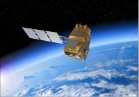
Figure 2: Artist's rendition of the deployed LSTM spacecraft (image credit: Airbus)
Jean-Marc Nasr, Head of Space Systems at Airbus said: “Measuring surface temperatures will help make agricultural production more efficient across the planet, benefitting us all. With Airbus on board all Copernicus Sentinel satellites to date, we are delighted that ESA is further entrusting us with this next generation mission for the world’s most ambitious Earth observation program. This contract again confirms Airbus’ position at the forefront of space technologies for Earth observation and as the world’s n°1 exporter.”
LSTM will operate from a low-Earth, polar orbit, to map both land-surface temperature and rates of evapotranspiration with unprecedented field-scale detail. It will be able to identify the temperatures of individual fields and image the Earth every three days at 50 m resolution. This is about 400 times more detail than is currently acquired from space. Its observations will cover a wide temperature range, from approx. -20°C to +30°C, with very high precision (0.3°C).
LSTM is the first Copernicus mission awarded to a Spanish company and the third ESA mission to be primed by Airbus in Madrid after the successful in orbit delivery of Cheops, the exoplanet hunter, and SEOSAT-Ingenio which is ready for launch. Being selected to lead this mission is a major milestone for space in Spain and again demonstrates ESA’s confidence in Airbus as a strong partner to prime ESA missions. The industrial consortium comprises more than 45 companies and institutions from up to 18 different countries. The support of the Spanish delegation to ESA was key in reaching this achievement.
Airbus has complete responsibility for the entire LSTM. It will design and build the LSTM satellite in Madrid, while the development and production of the advanced technology instrument will be carried out by Airbus in Toulouse.
The optical instrument flown on the LSTM satellite leverages Airbus’ latest innovations from programs such as the Franco-Indian TRISHNA mission to offer a best-in-class instrument. It will acquire images in Very Near Infrared, Short Wave Infrared and Thermal Infrared. With a four day revisit capability, the satellite will fly over European latitudes when the sun, and consequently stress on crops, are at their highest, to facilitate evapotranspiration measurement.
Overall, Airbus is responsible for the spacecraft or payload on 3 of the 6 new generation Copernicus Environment and Earth observation missions: LSTM, CRISTAL and Rose-L, and is providing critical equipment to all six.
|
The most ambitious and comprehensive plans ever for the European space sector, were approved at the end of 2019, with a total budget of €14.5 billion for ESA (European Space Agency) for the next three years – a 20% increase over the previous three-year budget. The decision allows a direct uplift to Europe’s Earth observation capability, expanding Copernicus – the European Union’s flagship Earth observation program – with a suite of new, high-priority satellite missions. In this explainer we delve into the improvements and what they mean for sustainability and climate science. The Sentinel System – new and improved At the center of the program sits the Copernicus Space Component, which includes a family of satellites known collectively as Sentinels. These spacecraft provide routine atmospheric, oceanic, cryosphere and land global monitoring data, which are made freely available for Copernicus Services and major research and commercial applications such as precision farming, environmental hazards monitoring, weather forecasting and climate resilience. The soon-to-be-expanded Sentinel system will incorporate six high-priority missions. Set to launch from 2025, each will bring new sensing capabilities. • Copernicus Anthropogenic CO2 Monitoring (CO2M): This mission will track individual sources of anthropogenic emissions of CO2 with a relatively high spatial-resolution imaging spectrometer. • Copernicus Land Surface Temperature Monitoring (LSTM): To monitor land surface temperature and rates of evapotranspiration in unprecedented detail via its thermal infrared radiometer. • Copernicus PolaR Ice and Snow Topography ALtimeter (CRISTAL): To chart sea-ice thickness and snow depth, as well as ice elevation on land equipped with radar instruments. • Copernicus Imaging Microwave Radiometer (CIMR): A marine-focused mission providing observations of sea-ice concentration, sea-surface temperature and salinity via passive microwave sensing. • Copernicus Hyperspectral Imaging Mission for the Environment (CHIME): Enhancing services for land-cover mapping,agricultural management and coastal mapping and management, with hyper-spectral imaging. • Radar Observing System for Europe – L-band (ROSE-L): A mission to support forest management, monitor soil moisture, and discriminate crop types equipped with an L-band radar sensor. What does this mean for sustainability and climate science? These new missions will complement the Sentinels and advance our knowledge about large-scale changes to the planet from natural and human activities. Some examples follow. Improved knowledge of emissions: The inability to monitor atmospheric carbon dioxide resulting from human activity at national and regional scales, is a major knowledge gap that was identified at COP-21 in Paris in 2015, and still remains problematic today. The CO2M mission will help address this issue by providing measurements to reduce current uncertainties in emissions estimates. Moreover, these new data will provide a unique and independent source of information to help assess the effectiveness of climate policy measures, and to track their impact towards decarbonizing Europe and meeting national emission reduction targets. Monitoring changes in the Arctic - Over the past few decades, global warming has led to widespread shrinking of the cryosphere. As detailed in the 2019 Special Report on the Ocean and Cryosphere we are seeing accelerating warming in the polar and high-mountain regions and reduced mass of ice sheets, ice caps and glaciers, reduced snow cover and Arctic sea ice extent and thickness. With increasingly rapid ocean and polar cryosphere transitions predicted in the near-term, it is critical to adequately monitor these sensitive regions as changes here will extend to the whole planet, with predominantly negative impacts on food security, water resources, ecosystems, livelihoods, health, as well as on the culture of human societies, particularly for Indigenous peoples. Future losses from polar ice sheets remain the largest uncertainty in global climate and sea level projects, whilst their scale and remote, hostile location make satellite measurements the only solution for tracking change. The deployment of CIMR and CRISTAL will ensure continuity of cryospheric observations at this crucial time. Advancing the UN Sustainable Development Goals (SDG): The SDGs provide a framework for global peace and prosperity, encompassing (among other aims) food security, sustainable water management and combating climate change and its impacts. To meet the commitment of achieving these goals by 2030, and to take action, decision-makers need empirical evidence on processes and changes in land and water systems and on their socioeconomic and human health impacts. The LSTM, ROSE-L and CHIME missions will improve our ability to monitor forests, biodiversity, agricultural land, and changes in the water and energy cycles to understand in more detail changes happening in both space and time, in support of the UN SDG goals for more sustainable allocation and use of resources. |
Table 1: Plans for a New Wave of European Sentinel Satellites 6)
1) Benjamin Koetz,Wim Bastiaanssen,Michael Berger,Joris Blommaert,Pierre Defourney,Umberto DelBello,Matthias Drusch,Mark Drinkwater,Ricardo Duca,Valerie Fernandez,Ferran Gascon,Darren Ghent,Radoslaw Guzinski,Jippe Hoogeveen,Simon Hook,Yann Kerr,Jean-Pierre Lagouarde,Ilias Manolis,Philippe Martimort,Andrea Marini,Jeff Masek,Michel Massart,Massimo Mementi,Claudia Notarnicola,Marcello Sallusti,Inge Sandholt,Jose Sobrino,Peter Strobl,Thomas Udelhoven, ”High Spatio- Temporal Resolution Land Surface Temperature Mission - a Copernicus Candidate Mission in Support of Agricultural Monitoring,” IGARSS 2018 (IEEE International Geoscience and Remote Sensing Symposium), 22-27 July 2018, Valencia, Spain, https://ieeexplore.ieee.org/document/8517433
2)//directory.eoportal.org/web/eoportal/satellite-missions/l/lstm#QE@hV11a3Herb" style="color: rgb(0, 155, 207);"> Joseph G. Alfieri, Martha C. Anderson, William P. Kustas, & Carmelo Cammalleri, 2017. “Effect of the revisit interval and temporal upscaling methods on the accuracy of remotely sensed evapotranspiration estimates.” Hydrology and Earth System Sciences, Volume 21(1) 2017, pp: 83–98, https://doi.org/10.5194/hess-21-83-2017
3) ”Plans for a New Wave of European Sentinel Satellites,” ESA, 2020, URL: https://futureearth.org
/wp-content/uploads/2020/01/issuebrief_04_03.pdf
4) ”Airbus wins ESA’s LSTM temperature-check mission for Copernicus next generation,” Airbus Press Release, 13 November 2020, URL: https://www.airbus.com/newsroom/press-releases/en/
2020/11/airbus-wins-esas-lstm-temperaturecheck-mission-for-copernicus-next-generation.html
5)//directory.eoportal.org/web/eoportal/satellite-missions/l/lstm#hq@hV1379Herb" style="color: rgb(0, 155, 207);"> ”Contracts signed for three high-priority environmental missions,” ESA Applications, 13 November 2020, URL: https://www.esa.int/Applications/Observing_the_Earth/
Copernicus/Contracts_signed_for_three_high-priority_environmental_missions
6) ”Plans for a New Wave of European Sentinel Satellites,” ESA, 2020, URL: https://futureearth.org
/wp-content/uploads/2020/01/issuebrief_04_03.pdf
The information compiled and edited in this article was provided by Herbert J. Kramer from his documentation of: ”Observation of the Earth and Its Environment: Survey of Missions and Sensors” (Springer Verlag) as well as many other sources after the publication of the 4th edition in 2002. - Comments and corrections to this article are always welcome for further updates ().


