
Displaying items by tag: ice
eOsphere Limited

eOsphere Limited is a UK based company specialising in satellite remote sensing applications.
Key areas of work are sea ice monitoring using satellite imagery and the provision of affordable ground receiving stations. eOsphere is involved in several research projects to develop better products about ice conditions, as well as working directly with companies who are operating in ice infested waters. The eOsphere ground station has been designed for users who want a reasonably priced system to receive and process data from EOS Terra and Aqua MODIS and the future planned NPP and NPOESS satellites.
IceBridge
IceBridge, a six-year NASA mission, is the largest airborne survey of Earth's polar ice ever flown. It will yield an unprecedented three-dimensional view of Arctic and Antarctic ice sheets, ice shelves and sea ice. These flights will provide a yearly, multi-instrument look at the behavior of the rapidly changing features of the Greenland and Antarctic ice.
Data collected during IceBridge will help scientists bridge the gap in polar observations between NASA's Ice, Cloud and Land Elevation Satellite (ICESat) -- in orbit since 2003 -- and ICESat-2, planned for early 2016. ICESat stopped collecting science data in 2009, making IceBridge critical for ensuring a continuous series of observations.
IceBridge will use airborne instruments to map Arctic and Antarctic areas once a year. IceBridge flights are conducted in March-May over Greenland and in October-November over Antarctica. Other smaller airborne surveys around the world are also part of the IceBridge campaign.
ICESat-2
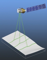
ICESat-2 (Ice, Cloud, and land Elevation Satellite 2), part of NASA's Earth Observing System, is a planned (year of writting: 2012) satellitemission for measuring ice sheet mass elevation, sea ice freeboard as well as land topography and vegetation characteristics. ICESat-2 is a planned follow-on to the ICESat mission. It will be launched in 2016 from Vandenberg Air Force Base in California into a near-circular, near-polar orbit with an altitude of approximately 496 km. It is being designed to operate for 3 years, and will carry enough propellant for 7 years.
The ICESat-2 mission is designed to provide elevation data needed to determine ice sheet mass balance as well as vegetation coverage information. It provides topography and vegetation data around the globe, in addition to the polar-specific coverage over the polar regions.
The ICESat-2 project is being managed by NASA Goddard Space Flight Center. The sole instrument is being designed and built by NASA Goddard Space Flight Center, and the bus is being provided by Orbital Sciences Corporation.
ICESat
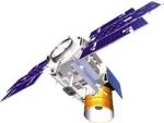
ICESat (Ice, Cloud, and land Elevation Satellite), part of NASA's Earth Observing System, was a satellite mission for measuring ice sheet mass balance, cloud and aerosol heights, as well as land topography and vegetation characteristics.
ICESat was launched 13 January 2003 on a Delta II rocket from Vandenberg Air Force Base in California into a near-circular, near-polar orbit with an altitude of approximately 600 km.
It operated for seven years before being retired in February 2010, after its scientific payload shut down and scientists were unable to restart it.
The ICESat mission was designed to provide elevation data needed to determine ice sheet mass balance as well as cloud property information, especially for stratospheric clouds common over polar areas. It provides topography and vegetation data around the globe, in addition to the polar-specific coverage over the Greenland and Antarctic ice sheets. The satellite was found useful in assessing important forest characteristics, including tree density.