Displaying items by tag: Earth observation
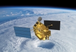
TRMM satellite
The Tropical Rainfall Measuring Mission (TRMM) is a joint space mission between NASA and the Japan Aerospace Exploration Agency (JAXA) designed to monitor and study tropical rainfall.
The term refers to both the mission itself and the satellite that the mission uses to collect data. TRMM is part of NASA's Mission to Planet Earth, a long-term, coordinated research effort to study the Earth as a global system.
The satellite was launched on November 27, 1997 from the Tanegashima Space Center in Tanegashima, Japan.
Skybox Imaging
Skybox Imaging is developing a high performance constellation of imaging micro-satellites to deliver high resolution imagery of any spot on Earth multiple times per day. Skybox sells timely satellite imagery and derived information products to commercial customers and governments worldwide.
The Skybox team's mission is to expand significantly the use of satellite imagery for commercial customers and governments alike.
Nov 2012: as we approach the launch date of our first satellite, SkySat-1, our team is focused on completing the construction of the satellite and ground infrastructure, as well as building strong relationships with our partners and customers. SkySat-1 is a commercial Earth observation satellite, licensed to collect high resolution panchromatic and multispectral images of the Earth. The satellite will operate in a polar inclined, circular orbit at approximately 450 km above the earth.
Remote Sensing and Photogrammetry Society (RSPSoc)
The Remote Sensing and Photogrammetry Society (RSPSoc) is a UK's Society for remote sensing and photogrammetry and their application to education, science, research, industry, commerce and the public service.
As a charity, its remit is to inform and educate its members and the public. It supports networking between the university, business and government sectors. Being an international society, RSPSoc is also active in Europe and on the world stage.
Geological Remote Sensing Group (GRSG)
The Geological Remote Sensing Group (GRSG) was founded in 1989 to foster awareness of remote sensing and related techniques in the geological and geophysical communities.
It comprises a mixed membership from industry, government and academic organizations, providing a balanced scientific, technical and commercial forum for discussion and debate. Its aims are pursued by means of a regular newsletter, a Web Site, and by holding regular meetings in the UK and overseas.
The GRSG is a special interest group of the Geological Society and the Remote Sensing and Photogrammetry Society (RSPSoc).
Satrec Initiative (SI)
Satrec Initiative (SI) is a satellite manufacturer offering proposing platforms for Earth observation missions, offering customers worldwide turnkey satellite platforms, electro-optical instruments, ground systems and components.
SI provides solutions for Earth observation missions and applications. SI activities cover the whole spectrum for Earth observation missions including spacecraft bus, Earth observation payload, communication equipment and satellite image receiving and processing system.
SI also provides technical consulting and engineering support from multi-disciplinary and highly experienced engineers and scientists.
SI was founded in 1999.
Spatial Energy
Spatial Energy is a provider of digital imagery and services within the energy industry.
Solely dedicated to meeting the needs of energy companies operating worldwide, Spatial Energy acquires, processes, and manages an extensive collection of high resolution satellite and aerial imagery, topographic maps, and digital elevation models (DEMs). Imagery is available on demand from an extensive data archives, by tasking satellites and aerial providers, and by speculative collection. Spatial Energy has established preferred relationships with the leading data providers and can thus select the best source(s) to meet a client particular application. In addition, programs such as the Energy Partner Program (EPP), BasinWatch and Spatial on Demand provide simplified, cost effective access to imagery. The company goal is to reduce the cost, time and effort required to acquire imagery for all client needs.
GEOSS
The Global Earth Observation System of Systems (GEOSS) will provide decision-support tools to a wide variety of users. It will proactively link together existing and planned observing systems around the world and support the development of new systems where gaps currently exist.
It is being built (in 2012) by the Group on Earth Observations (GEO), on the basis of a 10-Year Implementation Plan running from 2005 to 2015.
GEOSS seeks to connect the producers of environmental data and decision-support tools with the end users of these products, with the aim of enhancing the relevance of Earth observations to global issues. The result is to be a global public infrastructure that generates comprehensive, near-real-time environmental data, information and analyses for a wide range of users.
Group on Earth Observations (GEO)
The Group on Earth Observations is coordinating efforts to build a Global Earth Observation System of Systems, or GEOSS.
GEO was launched in response to calls for action by the 2002 World Summit on Sustainable Development and by the G8 (Group of Eight) leading industrialized countries. These high-level meetings recognized that international collaboration is essential for exploiting the growing potential of Earth observations to support decision making in an increasingly complex and environmentally stressed world.
GEO is a voluntary partnership of governments and international organizations. It provides a framework within which these partners can develop new projects and coordinate their strategies and investments. As of March 2012, GEO's Members include 88 Governments and the European Commission. In addition, 64 intergovernmental, international, and regional organizations with a mandate in Earth observation or related issues have been recognized as Participating Organizations.
GEO is constructing GEOSS on the basis of a 10-Year Implementation Plan for the period 2005 to 2015. The Plan defines a vision statement for GEOSS, its purpose and scope, expected benefits, and the nine "Societal Benefit Areas" of disasters, health, energy, climate, water, weather, ecosystems, agriculture and biodiversity.
The Group on Earth Observations is coordinating efforts to build a Global Earth Observation System of Systems, or GEOSS.
GMES / Copernicus
Global Monitoring for Environment and Security (GMES) is a joint initiative of the European Commission and European Space Agency, which aims at achieving an autonomous and operational Earth observation capacity.
The objective is to rationalize the use of multiple-sources data to get a timely and quality information, services and knowledge, and to provide autonomous and independent access to information in relation to environment and security. In other words, it will pull together all the information obtained by environmental satellites, air and ground stations to provide a comprehensive picture of the "health" of Earth.
GMES is the European Union contribution to the Global Earth Observation System of Systems GEOSS.
'Copernicus' is the new name for the GMES programme (June 2013). 
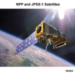
Suomi NPP
The Suomi National Polar-orbiting Partnership, or Suomi NPP, is a weather satellite operated by the United States National Oceanic and Atmospheric Administration.
Originally intended as a pathfinder for the NPOESS programme, which was to have replaced NOAA's Polar Operational Environmental Satellites and the US Air Force's Defense Meteorological Satellite Program, Suomi was launched in 2011 after the cancellation of NPOESS to serve as a gapfiller between the POES satellites and the Joint Polar Satellite System which will replace them. Its instruments provide climate measurements that continue prior observations by NASA's Earth Observing System.
it was previously known as the National Polar-orbiting Operational Environmental Satellite System Preparatory Project (NPP) and NPP-Bridge.


