
Displaying items by tag: polar orbit
EPS (EUMETSAT Polar System)
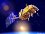
The EUMETSAT Polar System (EPS) is a European satellite system that offers remote sensing capabilities to both meteorologists and climatologists. It consists of a series of three polar orbiting Metop satellites, to be flown successively for more than 14 years, from 2006, together with the relevant ground facilities.
The satellites form the space segment component of the overall EPS system, which in turn is the European half of the EUMETSAT/NOAA Initial Joint Polar System (IJPS).
Metop-A (launched on 19 October 2006) and Metop-B (launched on 17 September 2012) are in a lower polar orbit, at an altitude of 817 kilometres, to provide more detailed observations of the global atmosphere, oceans and continents. The two satellites will operate in parallel for as long as Metop-A's available capacities bring benefits to users. Metop-C is due to be launched in 2017.
EPS Programme Background
EUMETSAT is responsible for coordinating all elements of the development, launch and operation of EPS satellites. This includes developing and procuring the ground segment; procuring the launcher and launch site, and operating the systems. Under the IJPS and Joint Transition Activities (JTA) agreement, EUMETSAT and NOAA have agreed to provide instruments for each other's satellites; exchange all data in real time, and assist each other with backup services. Other partners are European Space Agency and CNES.
The European and American satellites carry a set of identical sensors:
AVHRR/3 and the ATOVS suite consisting of AMSU-A, HIRS/4 and MHS. NOAA provides most of the joint instruments on board the satellites and EUMETSAT has developed and provides NOAA with the Microwave Humidity Sounder (MHS).
In addition, the Metop satellites carry a set of European sensors, IASI, ASCAT, GOME-2 and GRAS, aimed at improving atmospheric soundings, as well as measuring atmospheric ozone and near-surface wind vectors over the ocean. They also carry the Argos Advanced Data Collection System (A-DCS).
EPS-SG (programme)

EPS is a programme of Earth observation for Meteorology and weather forecast. The satellite is called METOP. EPS/METOP is managed by the European organisation EUMETSAT. Placed on a polar orbit, the satellite sends picture of the whole Earth.
EPS-SG is the Second Generation of this programme. (respectively the satellite is METOP-SG)
Activities are on-going (Aug. 2012) for the definition of the follow-on EUMETSAT Polar System, to replace the current satellite system in the 2020 timeframe and contribute to the Joint Polar System to be set up with NOAA. Through consultation with users and application experts, requirements have been defined for a range of candidate missions mainly in support of operational meteorology and climate monitoring. A number of on-board instruments, satellite platforms and ground support infrastructure are under study in coordination with ESA, NOAA, DLR and CNES. The satellites will fly, like Metop, in a sun synchronous, low earth orbit at 817 km altitude and 09:30 local time of the descending node, providing observations over the full globe with revisit times of 12 to 24 hours, depending on instrument. Feasibility studies are on-going with the main objective to define the baseline configuration for subsequent detailed design, development and operation programmes to be proposed and coordinated within the involved organisations. Started in 2005 under the name of Post-EPS, the activities will enter in 2012 the design and development phases under a new programme: EPS Second Generation (EPS-SG).
SPOT
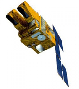
SPOT (Satellite Pour l’Observation de la Terre, lit. "Satellite for Earth Observation") is a high-resolution, optical imaging Earth observation satellite system operating from space. It is run by Spot Image based in Toulouse, France. It was initiated by the CNES (Centre national d'études spatiales — the French space agency) in the 1970s.
ERS - European Remote Sensing satellite
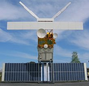
The European remote sensing satellite (ERS) was the European Space Agency's first Earth-observing satellite, injected into a Sun-synchronous polar orbit at a height of 782–785 km.
ERS-1 and ERS–2 were launched into the same orbit in 1991 and 1995 respectively. Their payloads included a synthetic aperture imaging radar, radar altimeter and instruments to measure ocean surface temperature and wind fields.
ERS-2 added an additional sensor for atmospheric ozone monitoring. The two satellites acquired a combined data set extending over two decades.