
Displaying items by tag: GPS
Wide Area Augmentation System (WAAS)
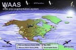
The Wide Area Augmentation System (WAAS) is an air navigation aid developed by the Federal Aviation Administration to augment the Global Positioning System (GPS).
The goal is to improve the GPS signal accuracy, integrity, and availability. Essentially, WAAS is intended to enable aircraft to rely on GPS for all phases of flight, including precision approaches to any airport within its coverage area.
WAAS uses a network of ground-based reference stations, in North America and Hawaii, to measure small variations in the GPS satellites' signals in the western hemisphere. Measurements from the reference stations are routed to master stations, which queue the received Deviation Correction and send the correction messages to geostationary WAAS satellites in a timely manner (every 5 seconds or better). Those satellites broadcast the correction messages back to Earth, where WAAS-enabled GPS receivers use the corrections while computing their positions to improve accuracy.
The International Civil Aviation Organization (ICAO) calls this type of system a satellite-based augmentation system (SBAS).
Similar service is provided in Asia, notably Japan, by the Multi-functional Satellite Augmentation System (MSAS), and in Europe by European Geostationary Navigation Overlay Service (EGNOS).
SGR-10 GPS Receiver
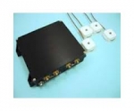
The Surrey Space GPS Receiver SGR-10 (2 antennae, 24 channels) is a single frequency, multiple antenna space GPS receiver designed as a spacecraft orbit determination subsystem for small satellite LEO applications.
The SGR-10 has two active patch antennas, and can be used for positioning only.
- Navigation for LEO missions
- 24 Channel L1 C/A Code Space GPS Receiver
- Fast start-up
- High visibility and redundancy
- Two active patch antennae included
- Price reflects batch build discount
- Delivery from batch build stock : 9 months
company: Surrey Satellite Technology
DeLorme

DeLorme is a vendor of mapping and GPS products and technologies. It is based in Yarmouth, Maine, United States.
DeLorme's products include Street Atlas USA, XMap, Topo USA and Earthmate GPS receivers (PN-20 and PN-40, BT-20, and LT-20).
The company is also a data solutions provider to several major businesses and industries.
Its headquarters features Eartha, the world's largest rotating globe. (in 2012)