Copernical Team
Filling the GOCE data gap unearths South Pole’s geological past

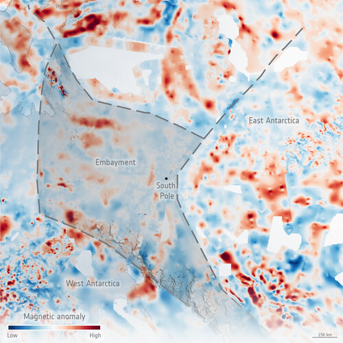
It’s very difficult to know what lies beneath a blanket of kilometres-thick ice, so it is hardly surprising that scientists have long contested the shape and geology of the ancient supercontinent from which East Antarctica formed over a billion years ago. An ESA-funded study can now lay some of this conjecture to rest. Using sensors on aircraft to measure changes in the gravity and magnetic signatures of the different rocks under the ice, scientists have discovered a huge bay the size of the UK formed part of the edge of
There's a big rock stuck inside one of Perseverance's wheels

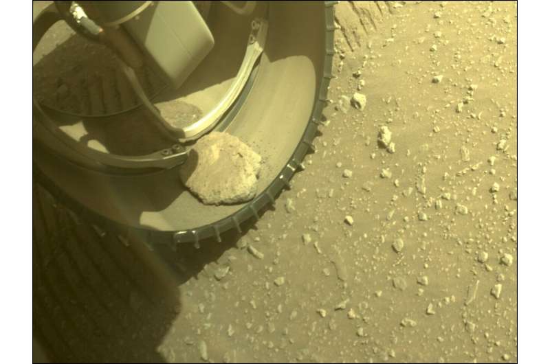
It looks like the Perseverance rover has an unwanted passenger, a rock stuck inside one of its wheels. The image of the stone was selected by public input as the "Image of the Week" for Week 54 (Feb. 20–26, 2022) of the Perseverance mission. Perseverance captured this image on February 25, 2022.
The rover's Front Left Hazard Avoidance Camera A captured the image. When the rover is driving, it makes periodic stops to let the Hazard Cameras survey the immediate surroundings. The Hazard Cameras help evaluate the hazards in front of and behind the rover, like large boulders, deep trenches, or dunes. The cameras create 3D views of the surroundings that help the rover make its own decisions without consulting with the rover team on Earth on every move.
The rock's been there for a few days, based on images from March 2. It's difficult to tell from the picture for sure, but it doesn't appear to be wedged in. Will it fall out during normal operations?
The rock doesn't appear to be causing any damage or hindering the rover's operations.
Team chosen to make first oxygen on the Moon

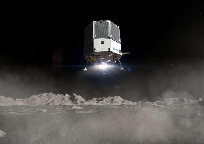
Following a design competition, ESA has selected the industrial team that will design and build the first experimental payload to extract oxygen from the surface of the Moon. The winning consortium, led by Thales Alenia Space in the UK, has been tasked with producing a small piece of equipment that will evaluate the prospect of building larger lunar plants to extract propellant for spacecraft and breathable air for astronauts – as well as metallic raw materials for equipment.
Stonehenge served as an ancient solar calendar - new analysis
 It had long been thought that the famous site of Stonehenge served as an ancient calendar, given its alignment with the solstices. Now, research has identified how it may have worked.
New finds about the stone circle's history, along with analysis of other ancient calendar systems, prompted Professor Timothy Darvill to take a fresh look at Stonehenge. His analysis, published in the journal
 Technology demonstration satellite to be launched soon
 China Aerospace Science and Industry Corp, a major defense contractor, plans to launch a technology demonstration satellite in the coming months, according to a senior researcher overseeing the project.
"The Tiankun 2 satellite is undergoing final tests by our engineers and will be launched by a Long March rocket," said Ma Jie, Party chief of the CASIC Second Academy in Beijing, which is d
 Amazon rainforest is losing resilience: New evidence from satellite data analysis
 The Amazon rainforest is likely losing resilience, data analysis from high-resolution satellite images suggests. This is due to stress from a combination of logging and burning - the influence of human-caused climate change is not clearly determinable so far, but will likely matter greatly in the future.
For about three quarters of the forest, the ability to recover from perturbation has b
 ElevationSpace raises $2.7M in seed-funding
 ElevationSpace Inc. (Headquartered: Sendai, Miyagi Prefecture, Japan, Co-Founder and CEO: Ryohei Kobayashi), a space startup company that originated at Tohoku University in Japan and develops a space environment utilization and recovery platform to replace the International Space Station (ISS), has raised seed funding of $2.7 million from six investors. Adding pre-seed funding, the total amount
 Galileo 2nd generation satellites ready to navigate into the future
 Airbus has successfully completed the Preliminary Design Review (PDR) for its system concept for the second generation Galileo navigation satellites. During this important milestone, Airbus' proposed preliminary design and the customer's system requirements have been fully reviewed and agreed.
This paves the way for further verification, acceptance and qualification at equipment and module
 Astronomers discover largest molecule yet in a planet-forming disc
 Using the Atacama Large Millimeter/submillimeter Array (ALMA) in Chile, researchers at Leiden Observatory in the Netherlands have for the first time detected dimethyl ether in a planet-forming disc. With nine atoms, this is the largest molecule identified in such a disc to date. It is also a precursor of larger organic molecules that can lead to the emergence of life.
"From these results,
 Dark energy: Neutron stars will tell us if it's only an illusion
 A huge amount of mysterious dark energy is necessary to explain cosmological phenomena, such as the accelerated expansion of the Universe, with Einstein's theory. But what if dark energy was just an illusion and general relativity itself had to be modified? A new SISSA study, published in Physical Review Letters, offers a new approach to answer this question.
Thanks to huge computational a
