
Copernical Team
Monday, 19 June 2023 06:22
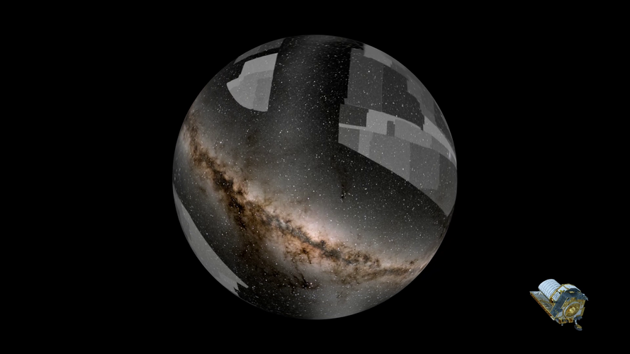
Euclid: ESA’s mission into the unknown
 Video:
00:03:29
Video:
00:03:29
ESA’s Euclid mission is designed to bring the dark side of the Universe to light. Based on the way galaxies rotate and orbit one another, and the way in which the Universe is expanding, astronomers believe that two unseen entities dominate the composition of our cosmos. They call these mysterious components dark matter and dark energy, yet to date we have not been able to detect either of them directly, only inferring their presence from the effects they have on the Universe at large.
To better understand what dark matter and dark energy may be, we need a
Published in
News
Tagged under
Sunday, 18 June 2023 23:59
SpaceX launches satellite to serve rural Indonesia
Washington DC (UPI) Jun 18, 2021
 SpaceX launched a Falcon 9 rocket Sunday carrying a communications satellite that will provide internet service to Indonesia.
The rocket launched from Space Launch Complex 40 at Cape Canaveral Space Force Station in Florida. The launch window opened at 6:04 p.m. but liftoff was delayed by about 15 minutes due to upper level winds. A backup window was prepared for Monday.
The rock
SpaceX launched a Falcon 9 rocket Sunday carrying a communications satellite that will provide internet service to Indonesia.
The rocket launched from Space Launch Complex 40 at Cape Canaveral Space Force Station in Florida. The launch window opened at 6:04 p.m. but liftoff was delayed by about 15 minutes due to upper level winds. A backup window was prepared for Monday.
The rock
Published in
News
Tagged under
Sunday, 18 June 2023 10:12
Shining potential of missing atoms
Vienna, Austria (SPX) Jun 15, 2023
 Single photons have applications in quantum computation, information networks, and sensors, and these can be emitted by defects in the atomically thin insulator hexagonal boron nitride (hBN). Missing nitrogen atoms have been suggested to be the atomic structure responsible for this activity, but it is difficult to controllably remove them. A team at the Faculty of Physics of the University of Vi
Published in
News
Tagged under
Sunday, 18 June 2023 10:12
Rise of the cute robots
Paris (AFP) June 15, 2023
 The red eye that refuses to be extinguished, the metal body that cannot be crushed - for many of us the word "robot" conjures one image: the Terminator.
But robots are now everywhere, serving as companions in care homes or vacuum cleaners in our homes, and manufacturers are keener than ever to design friendly machines.
"At first we noticed the kids could be a bit afraid," said Do Hwan K
The red eye that refuses to be extinguished, the metal body that cannot be crushed - for many of us the word "robot" conjures one image: the Terminator.
But robots are now everywhere, serving as companions in care homes or vacuum cleaners in our homes, and manufacturers are keener than ever to design friendly machines.
"At first we noticed the kids could be a bit afraid," said Do Hwan K
Published in
News
Tagged under
Sunday, 18 June 2023 10:12
Flying with NASA - Digital-Fly-By-Wire
Edwards AFB CA (SPX) Jun 16, 2023
 One of NASA Armstrong Flight Research Center's greatest contributions to commercial aviation is something that passengers never see - digital fly-by-wire flight controls.
Digital fly-by-wire technology replaces the heavy pushrods, cables, and pulleys previously used to move control surfaces on an aircraft's wings and tail. The technology uses a computer to send pilot commands by fiber opti
One of NASA Armstrong Flight Research Center's greatest contributions to commercial aviation is something that passengers never see - digital fly-by-wire flight controls.
Digital fly-by-wire technology replaces the heavy pushrods, cables, and pulleys previously used to move control surfaces on an aircraft's wings and tail. The technology uses a computer to send pilot commands by fiber opti
Published in
News
Tagged under
Sunday, 18 June 2023 10:12
We've pumped so much groundwater that we've nudged the Earth's spin
Seoul, South Korea (SPX) Jun 16, 2023
 By pumping water out of the ground and moving it elsewhere, humans have shifted such a large mass of water that the Earth tilted nearly 80 centimeters (31.5 inches) east between 1993 and 2010 alone, according to a new study published in Geophysical Research Letters, AGU's journal for short-format, high-impact research with implications spanning the Earth and space sciences.
Based on climat
By pumping water out of the ground and moving it elsewhere, humans have shifted such a large mass of water that the Earth tilted nearly 80 centimeters (31.5 inches) east between 1993 and 2010 alone, according to a new study published in Geophysical Research Letters, AGU's journal for short-format, high-impact research with implications spanning the Earth and space sciences.
Based on climat
Published in
News
Tagged under
Sunday, 18 June 2023 10:12
Seoul military salvages North Korea's space rocket wreckage
Seoul (AFP) June 16, 2023
 South Korea's military said Friday it had successfully retrieved a large chunk of a crashed North Korean space rocket from the sea bed after 15 days of complex salvage operations.
North Korea attempted to put its first military spy satellite into orbit on May 31, but the projectile and its payload crashed into the sea shortly after launch due to what Pyongyang said was a rocket failure.
South Korea's military said Friday it had successfully retrieved a large chunk of a crashed North Korean space rocket from the sea bed after 15 days of complex salvage operations.
North Korea attempted to put its first military spy satellite into orbit on May 31, but the projectile and its payload crashed into the sea shortly after launch due to what Pyongyang said was a rocket failure.
Published in
News
Tagged under
Sunday, 18 June 2023 10:12
NASA uses new air taxi ride simulator to test passenger comfort
Edwards AFB CA (SPX) Jun 18, 2023
 To create a future where air taxis are a regular form of transportation, passengers need to be comfortable. That's why researchers at NASA's Armstrong Flight Research Center in Edwards, California are exploring how passengers may experience an air taxi ride by building a custom virtual reality flight simulator.
NASA is currently researching the human physiological response to motion, vibra
To create a future where air taxis are a regular form of transportation, passengers need to be comfortable. That's why researchers at NASA's Armstrong Flight Research Center in Edwards, California are exploring how passengers may experience an air taxi ride by building a custom virtual reality flight simulator.
NASA is currently researching the human physiological response to motion, vibra
Published in
News
Tagged under
Sunday, 18 June 2023 10:12
USTC explored gravity's effect on quantum spins
Hefei, China (SPX) Jun 18, 2023
 A joint research group led by Prof. SHENG Dong and Prof. LU Zhengtian from the University of Science and Technology of China (USTC) of the Chinese Academy of Sciences (CAS), investigated the coupling effect between neutron spin and gravitational force via employing a high-precision xenon isotope magnetometer. This work was published in Physical Review Letters, entitled "Search for Spin-Dependent
A joint research group led by Prof. SHENG Dong and Prof. LU Zhengtian from the University of Science and Technology of China (USTC) of the Chinese Academy of Sciences (CAS), investigated the coupling effect between neutron spin and gravitational force via employing a high-precision xenon isotope magnetometer. This work was published in Physical Review Letters, entitled "Search for Spin-Dependent
Published in
News
Tagged under
Sunday, 18 June 2023 10:12
Innovation and investment propel Earth Observation industry to new heights
Los Angeles CA (SPX) Jun 18, 2023
 The Earth Observation (EO) industry continues to see a surge in technological innovation, satellite deployment, and investment opportunities, underlining the sector's pivotal role in our evolving understanding of our home planet.
Satellite deployment is rapidly increasing, with companies such as Muon Space, ICEYE, and Satellogic all announcing successful launches. Muon Space's debut satell
The Earth Observation (EO) industry continues to see a surge in technological innovation, satellite deployment, and investment opportunities, underlining the sector's pivotal role in our evolving understanding of our home planet.
Satellite deployment is rapidly increasing, with companies such as Muon Space, ICEYE, and Satellogic all announcing successful launches. Muon Space's debut satell
Published in
News
Tagged under


")


