

Copernical Team
Image: Astronaut captures photo of Earth from the International Space Station
This request seems a bit unusual, so we need to confirm that you're human. Please press and hold the button until it turns completely green. Thank you for your cooperation!
Press and hold the button
If you believe this is an error, please contact our support team.
185.132.36.159 : bf39b274-2c0f-4a43-bdaa-b4575a9f
Proba-3 will constantly measure Sun’s energy output
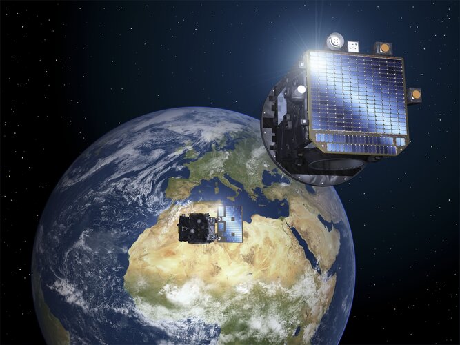
Proba-3 is such an ambitious mission that it needs more than one single spacecraft to succeed. In order for Proba-3’s Coronagraph spacecraft observe the Sun’s faint surrounding atmosphere, its disk-bearing Occulter spacecraft must block out the fiery solar disk. This means Proba-3’s Occulter ends up facing the Sun continuously, making it a valuable platform for science in its own right.
Meet ESA’s SME Office at Space Tech Expo 2024

Space startups and SMEs can meet ESA’s SME Office at Space Tech Expo, a space technology trade fair and conference in Bremen, Germany from 19–21 November.
Snow returns to Mount Fuji
 Image:
Snow returns to Mount Fuji
Image:
Snow returns to Mount Fuji Satellite imagery offers a way to shield coastal forests from climate impacts
 Rising sea levels driven by climate change threaten coastal forests with unpredictable consequences, highlighting the need for advanced tools to manage these vulnerable ecosystems and allocate conservation efforts effectively.
In a recent study by North Carolina State University and the U.S. Geological Survey (USGS), researchers explored how satellite imagery could help conservationists id
Rising sea levels driven by climate change threaten coastal forests with unpredictable consequences, highlighting the need for advanced tools to manage these vulnerable ecosystems and allocate conservation efforts effectively.
In a recent study by North Carolina State University and the U.S. Geological Survey (USGS), researchers explored how satellite imagery could help conservationists id 30 Years On, NASA's Wind Is a Windfall for Studying our Neighborhood in Space
 Picture it: 1994. The first World Wide Web conference took place in Geneva, the first Chunnel train traveled under the English Channel, and just three years after the end of the Cold War, the first Russian instrument on a U.S. spacecraft launched into deep space from Cape Canaveral. The mission to study the solar wind, aptly named Wind, held promise for heliophysicists and astrophysicists around
 UK MoD contracts SSTL for JUNO satellite
 Surrey Satellite Technology Ltd (SSTL) has finalized a contract with the UK Ministry of Defence (MoD) to build and supply an Earth Observation satellite, bolstering the UK's defense and technological capabilities in space.
This GBP 40 million project aims to equip the UK's armed forces with advanced space-based intelligence, surveillance, and reconnaissance (ISR) tools for global military
Surrey Satellite Technology Ltd (SSTL) has finalized a contract with the UK Ministry of Defence (MoD) to build and supply an Earth Observation satellite, bolstering the UK's defense and technological capabilities in space.
This GBP 40 million project aims to equip the UK's armed forces with advanced space-based intelligence, surveillance, and reconnaissance (ISR) tools for global military Russia to launch private Iranian satellites into orbit
 A Russian rocket will launch two privately built Iranian satellites into orbit early Tuesday, the Iranian embassy in Moscow said, hailing close space cooperation between Moscow and Tehran.
The two countries have deepened ties and trade amid Russia's military offensive on Ukraine and conflict in the Middle East, with space launches just one aspect of their burgeoning partnership.
"In cont
A Russian rocket will launch two privately built Iranian satellites into orbit early Tuesday, the Iranian embassy in Moscow said, hailing close space cooperation between Moscow and Tehran.
The two countries have deepened ties and trade amid Russia's military offensive on Ukraine and conflict in the Middle East, with space launches just one aspect of their burgeoning partnership.
"In cont Impulse Space selected for HALO Program by Space Development Agency
 Impulse Space, a leader in in-space transportation solutions, has been chosen by the Space Development Agency (SDA) to join the initial Hybrid Acquisition for Proliferated Low Earth Orbit (HALO) vendor pool. Impulse now stands among 19 companies selected for this critical program, underscoring its capabilities in advanced space technologies and positioning it to compete for future prototype demo
 BeiDou remote sensing experiment enhances ecological monitoring in Yellow River
 A large-scale integrated space-air-ground experiment, as part of the "BeiDou-enabled Remote Sensing Application Pilot Program," was conducted between July 20 and August 15 at the Yellow River Delta National Nature Reserve. This initiative aimed to improve ecological monitoring and develop more precise ecological assessments in the region.
The experiment incorporated a wide range of data co
A large-scale integrated space-air-ground experiment, as part of the "BeiDou-enabled Remote Sensing Application Pilot Program," was conducted between July 20 and August 15 at the Yellow River Delta National Nature Reserve. This initiative aimed to improve ecological monitoring and develop more precise ecological assessments in the region.
The experiment incorporated a wide range of data co