

Copernical Team
SpaceX's Elon Musk: 1st orbital Starship flight maybe March

SpaceX's Elon Musk said Thursday that the first orbital flight of his towering Starship—the world's most powerful rocket ever built—could come in another month or two.
While he anticipates failures, he's confident Starship will reach orbit by the end of this year.
Musk provided his first major Starship update in more than two years while standing alongside the 390-foot (119-meter) rocket at SpaceX's Texas spaceport. He urged the nighttime crowd, "Let's make this real!"
"This is really some wild stuff here," he said. "In fact, hard to believe it's real.
We explore - you benefit: Health, food, and climate
 Video:
00:04:45
Video:
00:04:45
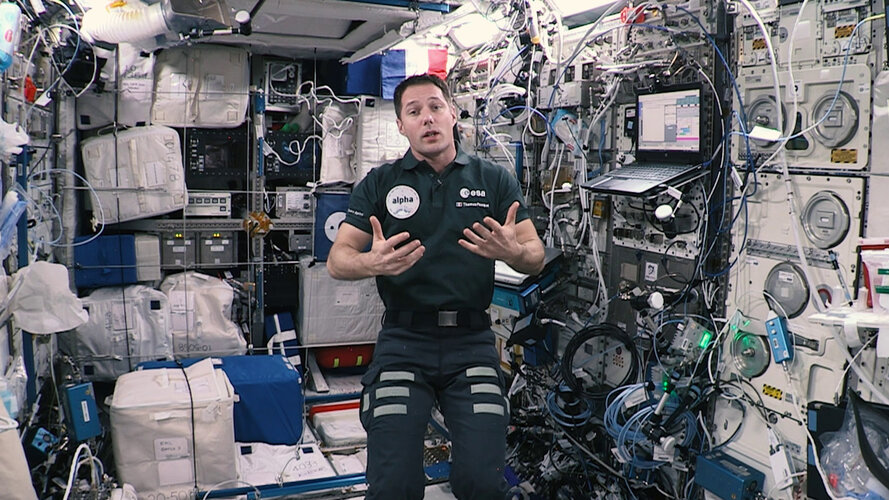
ESA astronaut Thomas Pesquet shows how space technologies and research onboard the International Space Station are used for the benefit of people on Earth. Thomas explains how space research is relevant to three of the United Nation’s goals: Health (SDG3), Zero hunger and food security (SDG2), and Climate action (SDG13). The Sustainable Development Goals are the world's to-do list for people and the planet by 2030.
Learn more about the European space laboratory, the Columbus module, and four examples of how space exploration supports sustainable development in Europe and in Africa.
This video is Part 2 of a
We explore - you benefit: water and sanitation
 Video:
00:05:43
Video:
00:05:43
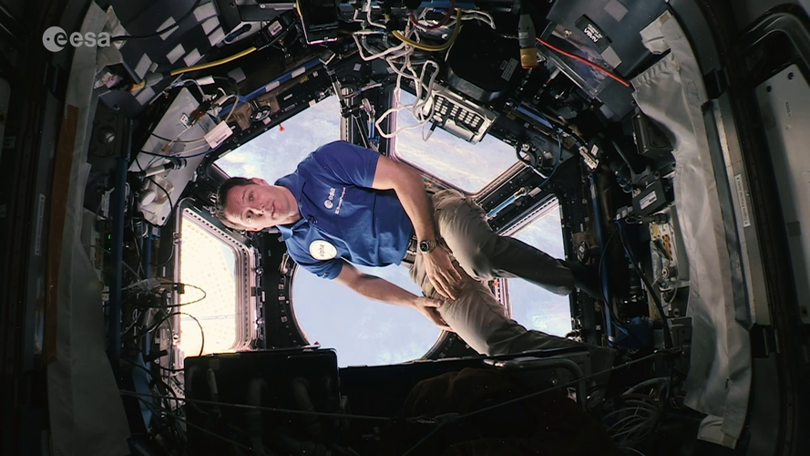
Join ESA astronaut Thomas Pesquet as he explains the benefits of space exploration technologies and activities for Earth. This video is focused on the life support technologies originally developed for astronauts and shows how space research on water recycling for deep-space exploration is contributing to sustainable development in Europe and in Africa.
In this video Thomas explains how space research is relevant to the sixth United Nation’s goal ‘Clean Water and Sanitation’. The Sustainable Development Goals are the world's to-do list for people and the planet by 2030.
This video is Part 1 of a 2-part series that describes
First visible light images of Venus' surface from space captured by Parker Solar Probe
 On a flyby of Venus, NASA's Parker Solar Probe captured the first visible light images of the cloudy planet's surface from space, a new study reports. The nightside view of the extremely hot surface could help scientists understand the contrasting evolution of Earth's nearest neighbor.
Smothered in thick clouds, Venus' surface is usually shrouded from sight. But in two recent flybys of the
On a flyby of Venus, NASA's Parker Solar Probe captured the first visible light images of the cloudy planet's surface from space, a new study reports. The nightside view of the extremely hot surface could help scientists understand the contrasting evolution of Earth's nearest neighbor.
Smothered in thick clouds, Venus' surface is usually shrouded from sight. But in two recent flybys of the SwRI scientists help determine comet delivery to Moon
 Southwest Research Institute scientists joined a team that reanalyzed and modeled data from a planned lunar impact more than a decade ago. The findings suggest that volatiles present in a crater near the Moon's south pole were likely delivered by a comet. Volatiles are chemical elements and compounds that can be readily vaporized and, in this case, were stabilized in ice lurking in this permanen
 Solar storm knocks out 40 SpaceX Starlink satellites
 A solar storm has knocked out 40 of 49 SpaceX Starlink broadband communications satellites the company launched on Thursday, the company said.
While the loss of dozens of spacecraft is likely a multimillion-dollar blow to SpaceX, the Starlink business plan will survive and the satellites do not pose a risk to Earth as they fall back and burn up in the atmosphere, Harvard astrophysicist
A solar storm has knocked out 40 of 49 SpaceX Starlink broadband communications satellites the company launched on Thursday, the company said.
While the loss of dozens of spacecraft is likely a multimillion-dollar blow to SpaceX, the Starlink business plan will survive and the satellites do not pose a risk to Earth as they fall back and burn up in the atmosphere, Harvard astrophysicist SpaceX Starship orbital flight likely this year
 SpaceX founder and CEO Elon Musk gave an update plans for the company's Starship rocket on Thursday night in South Texas, as the company prepares for the rocket's first orbital test flight, saying it would fly sometime this year - a less ambitious time frame than he'd previously offered.
SpaceX has not yet received approval from the Federal Aviation Administration to launch orbital fli
SpaceX founder and CEO Elon Musk gave an update plans for the company's Starship rocket on Thursday night in South Texas, as the company prepares for the rocket's first orbital test flight, saying it would fly sometime this year - a less ambitious time frame than he'd previously offered.
SpaceX has not yet received approval from the Federal Aviation Administration to launch orbital fli Spire Global completes acquisition of exactEarth
 Spire, a leading provider of space-based data, analytics and space services, has successfully completed its previously announced acquisition of exactEarth Ltd., a leading provider of global maritime vessel data for ship tracking and maritime situational awareness solutions, by way of a plan of arrangement, following the completion of all closing conditions.
The Arrangement, which was annou
Spire, a leading provider of space-based data, analytics and space services, has successfully completed its previously announced acquisition of exactEarth Ltd., a leading provider of global maritime vessel data for ship tracking and maritime situational awareness solutions, by way of a plan of arrangement, following the completion of all closing conditions.
The Arrangement, which was annou Musk 'confident' of Starship orbital launch this year
 Elon Musk delivered updates on SpaceX's efforts to develop its interplanetary Starship rocket on Thursday night, but stopped short of announcing a firm launch date for an orbital test or new missions, despite considerable buildup ahead of the rare presentation.
Addressing an audience at the company's Starbase facility near Boca Chica, south Texas, the tycoon merely said: "I feel at this poi
Elon Musk delivered updates on SpaceX's efforts to develop its interplanetary Starship rocket on Thursday night, but stopped short of announcing a firm launch date for an orbital test or new missions, despite considerable buildup ahead of the rare presentation.
Addressing an audience at the company's Starbase facility near Boca Chica, south Texas, the tycoon merely said: "I feel at this poi Astra Space stock plunges after rocket failure during NASA launch
 California-based Astra Space suffered a rocket failure during launch of a NASA mission from Florida on Thursday after two previous delays.
The company's stock plunged by more than 32% to $3.59 following the launch failure, but recovered a portion of that loss in subsequent trades. The plunge prompted a brief trading halt by the Nasdaq.
NASA's Launch Services Program, which had hi
California-based Astra Space suffered a rocket failure during launch of a NASA mission from Florida on Thursday after two previous delays.
The company's stock plunged by more than 32% to $3.59 following the launch failure, but recovered a portion of that loss in subsequent trades. The plunge prompted a brief trading halt by the Nasdaq.
NASA's Launch Services Program, which had hi