

Copernical Team
Hubble reveals surviving companion star in aftermath of supernova
 NASA's Hubble Space Telescope has uncovered a witness at the scene of a star's explosive death: a companion star previously hidden in the glare of its partner's supernova. The discovery is a first for a particular type of supernova - one in which the star was stripped of its entire outer gas envelope before exploding.
The finding provides crucial insight into the binary nature of massive s
NASA's Hubble Space Telescope has uncovered a witness at the scene of a star's explosive death: a companion star previously hidden in the glare of its partner's supernova. The discovery is a first for a particular type of supernova - one in which the star was stripped of its entire outer gas envelope before exploding.
The finding provides crucial insight into the binary nature of massive s NASA's Swift tracks potential magnetic flip of monster black hole
 A rare and enigmatic outburst from a galaxy 236 million light-years away may have been sparked by a magnetic reversal, a spontaneous flip of the magnetic field surrounding its central black hole.
In a comprehensive new study, an international science team links the eruption's unusual characteristics to changes in the black hole's environment that likely would be triggered by such a magneti
A rare and enigmatic outburst from a galaxy 236 million light-years away may have been sparked by a magnetic reversal, a spontaneous flip of the magnetic field surrounding its central black hole.
In a comprehensive new study, an international science team links the eruption's unusual characteristics to changes in the black hole's environment that likely would be triggered by such a magneti NASA's Psyche starts processing at Kennedy
 Bound for an asteroid of the same name, the orbiter is undergoing final preparations for its August launch.
Since its arrival on April 29, the Psyche spacecraft has moved into the Payload Hazardous Servicing Facility at NASA's Kennedy Space Center in Florida, where technicians removed it from its protective shipping container, rotated it to vertical, and have begun the final steps to prepa
Bound for an asteroid of the same name, the orbiter is undergoing final preparations for its August launch.
Since its arrival on April 29, the Psyche spacecraft has moved into the Payload Hazardous Servicing Facility at NASA's Kennedy Space Center in Florida, where technicians removed it from its protective shipping container, rotated it to vertical, and have begun the final steps to prepa Solving the mystery of frost hiding on Mars
 A new study using data from NASA's Mars Odyssey orbiter may explain why Martian frost can be invisible to the naked eye and why dust avalanches appear on some slopes.
Scientists were baffled last year when studying images of the Martian surface taken at dawn by NASA's Mars Odyssey orbiter. When they looked at the surface using visible light - the kind that the human eye perceives - they co
A new study using data from NASA's Mars Odyssey orbiter may explain why Martian frost can be invisible to the naked eye and why dust avalanches appear on some slopes.
Scientists were baffled last year when studying images of the Martian surface taken at dawn by NASA's Mars Odyssey orbiter. When they looked at the surface using visible light - the kind that the human eye perceives - they co Examining the Heart of Webb: The Final Phase of Commissioning
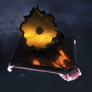
 NASA's James Webb Space Telescope is now experiencing all seasons - from hot to cold - as it undergoes the thermal stability test. Meanwhile, activities are underway for the final phase of commissioning: digging into the details of the science instruments, the heart of Webb. To complete commissioning, we will measure the detailed performance of the science instruments before we start routine sci
 NASA identifies Artemis 1 rocket issues, plans another wet dress rehearsal for June
 NASA is targeting early June for its next attempt of the Artemis 1 wet dress rehearsal, officials announced on Thursday.
The test aims to demonstrate that the rocket can be safely loaded with propellant and practice the launch day procedures, aside from actually launching, to identify concerns and potential issues.
Previous attempts at the wet dress, conducted in April, resulted
NASA is targeting early June for its next attempt of the Artemis 1 wet dress rehearsal, officials announced on Thursday.
The test aims to demonstrate that the rocket can be safely loaded with propellant and practice the launch day procedures, aside from actually launching, to identify concerns and potential issues.
Previous attempts at the wet dress, conducted in April, resulted Astronaut crew returning to Earth after six months on ISS
 NASA astronauts Tom Marshburn and Raja Chari and (L-R back) European Space Agency astronaut Matthias Maurer of Germany and NASA astronaut Kayla Barron as they prepared to launch for the ISS.")
NASA's Crew-3 mission was returning home to Earth on Thursday after six months aboard the International Space Station.
The SpaceX Dragon Endurance spacecraft with NASA astronauts Kayla Barron, Raja Chari, and Tom Marshburn, as well as European Space Agency astronaut Matthias Maurer undocked from the orbital laboratory overnight.
Their 23.5 hour journey back should see them splash down off the coast of Florida at 12:43 am on Friday (0443 GMT).
They leave behind the one Italian and three American astronauts of Crew-4, and three Russian cosmonauts.
NASA's Psyche spacecraft starts processing at Kennedy Space Center

Bound for an asteroid of the same name, the orbiter is undergoing final preparations for its August launch.
Since its arrival on April 29, the Psyche spacecraft has moved into the Payload Hazardous Servicing Facility at NASA's Kennedy Space Center in Florida, where technicians removed it from its protective shipping container, rotated it to vertical, and have begun the final steps to prepare the spacecraft for launch. In the coming months, crews will perform a range of work including reinstalling solar arrays, reintegrating a radio, testing the telecommunications system, loading propellants, and encapsulating the spacecraft inside payload fairings before it leaves the facility and moves to the launch pad.
Lunar soil has the potential to generate oxygen and fuel

Soil on the moon contains active compounds that can convert carbon dioxide into oxygen and fuels, scientists in China report May 5 in the journal Joule. They are now exploring whether lunar resources can be used to facilitate human exploration on the moon or beyond.
Nanjing University material scientists Yingfang Yao and Zhigang Zou hope to design a system that takes advantage of lunar soil and solar radiation, the two most abundant resources on the moon. After analyzing the lunar soil brought back by China's Chang'e 5 spacecraft, their team found the sample contains compounds—including iron-rich and titanium-rich substances—that could work as a catalyst to make desired products such as oxygen using sunlight and carbon dioxide.
Based on the observation, the team proposed an "extraterrestrial photosynthesis" strategy. Mainly, the system uses lunar soil to electrolyze water extracted from the moon and in astronauts' breathing exhaust into oxygen and hydrogen powered by sunlight.
NASA to Discuss Webb Telescope Alignment, Instrument Setup
 NASA will hold a media teleconference at 11 a.m. EDT on Monday, May 9, to discuss progress toward preparing the James Webb Space Telescope for science operations.