

Copernical Team
Lost in space: Astronauts struggle to regain bone density
 Astronauts lose decades' worth of bone mass in space that many do not recover even after a year back on Earth, researchers said Thursday, warning that it could be a "big concern" for future missions to Mars.
Previous research has shown astronauts lose between one to two percent of bone density for every month spent in space, as the lack of gravity takes the pressure off their legs when it co
Astronauts lose decades' worth of bone mass in space that many do not recover even after a year back on Earth, researchers said Thursday, warning that it could be a "big concern" for future missions to Mars.
Previous research has shown astronauts lose between one to two percent of bone density for every month spent in space, as the lack of gravity takes the pressure off their legs when it co Life in the abyss, a spectacular and fragile struggle for survival
 Cloaked in darkness and mystery, the creatures of the deep oceans exist in a world of unlikely profusion, surviving on scant food and under pressure that would crush human lungs.
This extremely hostile environment, which will come under the spotlight at a major United Nations oceans summit in Lisbon this week, has caused its inhabitants to develop a prodigious array of alien characteristics
Cloaked in darkness and mystery, the creatures of the deep oceans exist in a world of unlikely profusion, surviving on scant food and under pressure that would crush human lungs.
This extremely hostile environment, which will come under the spotlight at a major United Nations oceans summit in Lisbon this week, has caused its inhabitants to develop a prodigious array of alien characteristics Humans in the loop help robots find their way
 Just like us, robots can't see through walls. Sometimes they need a little help to get where they're going. Engineers at Rice University have developed a method that allows humans to help robots "see" their environments and carry out tasks. The strategy called Bayesian Learning IN the Dark - BLIND, for short - is a novel solution to the long-standing problem of motion planning for robots that wo
 SpaceX launches first C-band television broadcast satellite into space for SES
 The first television broadcast satellite under SES's C-band lifted off from Cape Canaveral on Wednesday evening on a SpaceX rocket.
SES, a video and data solutions company, said the satellite will free up the lower 300 MHz of C-band spectrum to ensure the company can provide video and data services to its customers while enabling wireless operators to quickly deploy 5G services across t
The first television broadcast satellite under SES's C-band lifted off from Cape Canaveral on Wednesday evening on a SpaceX rocket.
SES, a video and data solutions company, said the satellite will free up the lower 300 MHz of C-band spectrum to ensure the company can provide video and data services to its customers while enabling wireless operators to quickly deploy 5G services across t Earth from Space: Patagonia
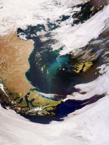
The Copernicus Sentinel-3 mission captured this impressive, wide-angled view of Patagonia at the southern end of South America, as well as the Falkland Islands (Malvinas).
Another Webb telescope instrument gets the 'go for science'

The second of NASA's James Webb Space Telescope's four primary scientific instruments, known as the Mid-Infrared instrument (MIRI), has concluded its postlaunch preparations and is now ready for science.
The last MIRI mode to be checked off was its coronagraphic imaging capability, which uses two different styles of masks to intentionally block starlight from hitting its sensors when attempting to make observations of the star's orbiting planets. These customized masks allow for scientists to directly detect exoplanets and study dust disks around their host stars in a way that's never been done before.
Along with Webb's three other instruments, MIRI initially cooled off in the shade of Webb's tennis-court-size sunshield to about 90 Kelvin (minus 298 degrees Fahrenheit, or minus 183 degrees Celsius). To perform its intended science meant dropping to less than 7 Kelvin—just a few degrees above the lowest temperature matter can reach—by using an electrically powered cryocooler. These extreme operating temperatures allow for MIRI to deliver mid-infrared images and spectra with an unprecedented combination of sharpness and sensitivity.
Two Seattle startups racing to transform next-gen space travel

The phrase "nuclear energy" conjures images of large steaming towers or Tony Stark's arc reactor from the iconic "Iron Man" movies. But two Seattle-based startups are designing nuclear technologies small enough to pick up and carry that, thanks in part to buy-in from the Defense Department, they hope will fuel a new generation of spaceships.
Seattle's Avalanche Energy and Ultra Safe Nuclear Corporation received undisclosed amounts of funding from the Pentagon's Defense Innovation Unit in May to further develop two different approaches to small-scale nuclear power.
Avalanche is pushing the boundaries of nuclear fusion while Ultra Safe aims to revolutionize nuclear radioisotope batteries, like those that power Mars rovers. Both companies are expected to deliver functional prototype spacecraft to the Pentagon by 2027.
"Nuclear is an interesting area because traditionally that's been mainly in the realm of government," said U.S. Air Force Maj. Ryan Weed, the program manager for the Defense Innovation Unit's nuclear propulsion and power program. The unit—the Pentagon's outpost in Silicon Valley—works exclusively with private sector companies to adapt emerging technologies for military use.
After six decades of materials science research, nuclear fuels are relatively safe and are being embraced in the private sector.
Smart earbud will measure how astronauts sleep

Sleep is important for our health and well-being, and bad sleep can negatively impact our attention span, memory, decision-making skills, creativity and judgment.
Astronauts living in zero gravity with an artificial day-night cycle have trouble maintaining a natural circadian rhythm and normal sleep patterns. In fact, sleep is what astronauts complain about the most.
To avoid the negative short- and long-term side effects of poor sleep, Aarhus University's Centre for Ear-EEG has developed a technology that can monitor an astronaut's sleep in a non-invasive and discreet manner via so-called "ear-EEG" (ear-ElectroEncephaloGraphy). The technology, along with Danish astronaut Andreas Mogensen, will travel to the International Space Station ISS to examine the differences between human sleep patterns on earth and in space.
The project is called "Sleep in Orbit."
"Sleep is a kind of biomarker for our health and well-being. In fact, a great many diseases also impact the way we sleep, including a wide range of psychiatric disorders and neurodegenerative diseases.
The path of most resistance could help limit bone loss during spaceflight

Astronauts that have returned after spaceflights over three months may show signs of incomplete bone recovery even after one year on Earth, but adding in more resistance-based exercises during spaceflight may help limit bone loss. The small study, published in Scientific Reports, on 17 international astronauts found that while the shinbone partially recovers, the sustained bone losses after one year are equivalent to ten years of normal age-related bone loss on Earth.
Steven Boyd and colleagues imaged 17 astronauts (14 male, three female) before spaceflight, at return to Earth, and after six and 12 months of recovery. They conducted bone scans on the tibia (shinbone) and radius (forearm) to calculate the resistance of the bone to fracture (failure load), bone mineral in the bone tissue, and tissue thickness. The authors also recorded exercises such as cycling, treadmill running and deadlifting completed by astronauts in-flight and post-flight.
One year after flight the median results for 16 of the astronauts showed incomplete recovery of the shinbone. Median shinbone failure load, measuring bone strength, was reduced by 152.0 newtons from 10,579 newtons at pre-flight to 10,427 newtons after one year.
Copernicus Sentinel-1 maps Bangladesh flood
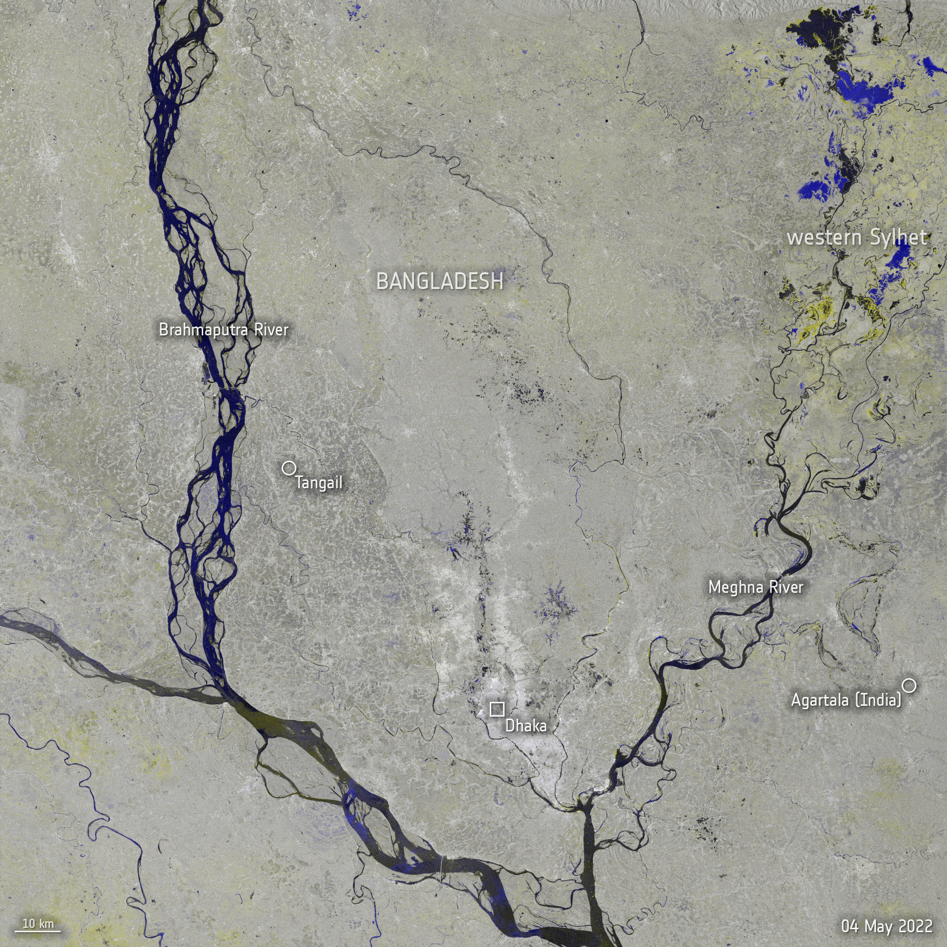 Image:
Copernicus Sentinel-1 maps Bangladesh flood
Image:
Copernicus Sentinel-1 maps Bangladesh flood