
Displaying items by tag: instrument
Sodern

Sodern is a French company based in Limeil-Brévannes, near Paris in Ile-de-France, specialized in space instrumentation, optics and neutron analyzers.
Sodern activity started in the neutron area, by designing neutron sources for the French deterrent force. In the late 1960s, it began to diversify into optical sensors and advanced spacecraft instrumentation.
Nowadays (2015) the company is active in the following fields:
- Spatial Instrumentation: activities cover several ranges of space instruments.
- Stars Trackers
- Optical Instrumentation
- Strip Filters
Geoscience Laser Altimeter System (GLAS)
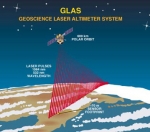
The Geoscience Laser Altimeter System (GLAS) is an instrument onboard the ICESat satellite.
This instrument will determine the distance from the satellite to the Earth's surface and to intervening clouds and aerosols. It will do this by precisely measuring the time it takes for a short pulse of laser light to travel to the reflecting object and return to the satellite. Although surveyors routinely use laser methods, the challenge for ICESat is to perform the measurement 40 times a second from a platform moving 26,000 km (16,000 mi) per hour. In addition, ICESat will be 600 km above the Earth and the precise locations of the satellite in space and the laser beam on the surface below must be determined at the same time.
Kayser-Threde GmbH

Kayser-Threde GmbH based in Munich, Germany, is a company specializing in the design and development of high-technology solutions for astronautics, science and the industry.
The activities include applications in manned and unmanned space missions, optical systems, and process control.
Since June 2007 Kayser-Threde belongs to OHB AG.
Ball Aerospace

Ball Aerospace & Technologies Corp. (commonly Ball Aerospace) is a manufacturer of spacecraft, components, and instruments for national defense, civil space and commercial space applications.
This American company is a wholly owned subsidiary of Ball Corp., with primary offices in Boulder and facilities in Broomfield and Westminster in Colorado, with smaller offices in New Mexico, Ohio, Georgia, Northern Virginia, and Maryland.
Ball Aerospace began building pointing controls for military rockets in 1956, and later won a contract to build one of NASA’s first spacecraft, the Orbiting Solar Observatory. Over the years, the company has been responsible for numerous technological and scientific projects and continues to provide aerospace technology to NASA and related industries.
MISR
The Multi-angle Imaging SpectroRadiometer (MISR) is a scientific instrument on the Terra satellite launched by NASA on December 18, 1999. This device is designed to measure the intensity of solar radiation reflected by the Earth system (planetary surface and atmosphere) in various directions and spectral bands; it became operational in February 2000. Data generated by this sensor have been proven useful in a variety of applications including atmospheric sciences, climatology and monitoring terrestrial processes.
The MISR instrument consists of an innovative configuration of nine separate digital cameras that gather data in four different spectral bands of the solar spectrum. One camera points toward the nadir, while the others provide forward and aftward view angles at 26.1°, 45.6°, 60.0°, and 70.5°. As the instrument flies overhead, each region of the Earth's surface is successively imaged by all nine cameras in each of four wavelengths (blue, green, red, and near-infrared).
The data gathered by MISR are useful in climatological studies concerning the disposition of the solar radiation flux in the Earth's system. MISR is specifically designed to monitor the monthly, seasonal, and long-term trends of atmospheric aerosol particle concentrations including those formed by natural sources and by human activities, upper air winds and cloud cover, type, height, as well as the characterization of land surface properties, including the structure of vegetation canopies, the distribution of land cover types, or the properties of snow and ice fields, amongst many other biogeophysical variables.
SAR

Synthetic-aperture radar (SAR) is a form of radar whose defining characteristic is its use of relative motion between an antenna and its target region to provide distinctive long-term coherent-signal variations that are exploited to obtain finer spatial resolution than is possible with conventional beam-scanning means. It originated as an advanced form of side-looking airborne radar (SLAR).
SAR is usually implemented by mounting, on a moving platform such as an aircraft or spacecraft, a single beam-forming antenna from which a target scene is repeatedly illuminated with pulses of radio waves at wavelengths anywhere from a meter down to millimeters. The many echo waveforms received successively at the different antenna positions are coherently detected and stored and then post-processed together to resolve elements in an image of the target region.
Current (2010) airborne systems provide resolutions to about 10 cm, ultra-wideband systems provide resolutions of a few millimeters, and experimental terahertz SAR has provided sub-millimeter resolution in the laboratory.
SAR images have wide applications in remote sensing and mapping of the surfaces of both the Earth and other planets. SAR can also be implemented as "inverse SAR" by observing a moving target over a substantial time with a stationary antenna.