

 Image:
This Copernicus Sentinel-1 radar image shows Tokyo and its metropolitan area, the largest urban agglomeration in the world.
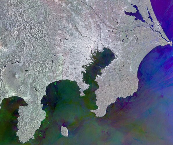
Image:
This Copernicus Sentinel-1 radar image shows Tokyo and its metropolitan area, the largest urban agglomeration in the world. This Copernicus Sentinel-1 radar image shows Tokyo and its metropolitan area, the largest urban agglomeration in the world.
Zoom in to explore this image at its full 10 m resolution.
Japan’s capital lies on the eastern shore of Honshu, the largest of Japan’s four main islands. Tokyo city has more than 14 million inhabitants, while the Greater Tokyo Area, which includes Tokyo and parts of the neighbouring prefectures, is home to more than 40 million people.
The bright grey and white tones of this urban conurbation dominate the centre of the image and are in sharp contrast to the colours in the ocean and water bodies.
Three main rivers can be seen winding through the urban area, then flowing into Tokyo Bay. The central river is the Arakawa, with the Edo river to the north and the Tama to the south. Tokyo’s centre lies mainly south of the Arakawa river, while at the mouth of the Tama, the runways of Haneda Airport are also visible.
This image is a combination of three radar acquisitions during 2024 and highlights changes that occurred between each capture. A colour is assigned to each acquisition date: red for 16 August, green for 28 August and blue for 9 September.
Shades of grey indicate areas with no changes, such as the Tokyo Metropolitan Area with a high density of structures and buildings, which appear bright grey or white.
The mix of colours in the ocean water denotes changes on the surface, which occurred during the dates of acquisition, caused by winds or currents. Ships in Tokyo Bay appear as multi-coloured dots, with the colour corresponding to the date of acquisition.
In the top right corner, Lake Kasumigaura stands out in dark blue hues, due to its surface roughness during the third acquisition. One of the activities carried out on Kasumigaura is pearl cultivation, with its structures seen as white, rectangular features on the lake.
Radar data are particularly useful for detecting surface features and are therefore used to map the topography. For example, in the left side of the image we can see the mountain reliefs of the Chichibu-Tama-Kai National Park in the upper part and Mount Fuji to its south near the coast.
The Copernicus Sentinel-1 mission provides all-weather, day-and-night radar imagery of Earth’s land and oceans, which is useful for monitoring evolving situations, such as ground movements, urban development and ship tracking.