

 Image:
Captured on 7 May 2024, this Copernicus Sentinel-2 image shows part of New Zealand’s North Island.
Image:
Captured on 7 May 2024, this Copernicus Sentinel-2 image shows part of New Zealand’s North Island. Captured on 7 May 2024, this Copernicus Sentinel-2 image shows part of New Zealand’s North Island.
Zoom in to explore this image at its full 10 m resolution or click on the circles to learn more.
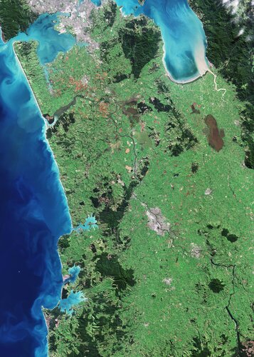
New Zealand lies in the South Pacific Ocean and comprises two major islands – North and South – and a number of smaller islands.
Much of North Island’s terrain in this image is dominated by lush vegetation, with darker green areas denoting dense forested zones.
Urban centres appear in grey. Towards the top of the image, the city of Auckland can be seen as a large, grey area adjacent to the Hauraki Gulf to the east and the Manukau Harbour to the west. Auckland is the country’s most populous city and its largest port. A focal point for transportation, the city is also served by New Zealand’s leading international airport, which can be spotted in the centre of Manukau Harbour.
Moving south, the largest grey area in the middle of the image is Hamilton, one of the country’s most important inland centres. It straddles the Waikato River, the longest river in New Zealand, which can be seen as a dark, winding line across the bottom right of the image, bisecting Hamilton into two nearly symmetrical parts.
As it winds its course, the Waikato meanders through a patchwork of agricultural fields that cover the plain between Auckland and Hamilton. The green and brown hues of the fields shift according to the crop type and their various stages of growth.
Before entering the Tasman Sea, south of Auckland, the Waikato River forms an estuary, which feeds a network of marshes and creates numerous small islands.
On the coast, bright, turquoise colours in the Tasman Sea suggest the presence of sediment being carried into the ocean by river discharge. The swirls in the sea show how the currents transport sediment.
A number of lakes and wetlands can be spotted near the centre of the image, including the Whangamarino Wetland, an extensive mosaic of swamps and bogs, visible as a dark brown area east of the Waikato River. The Kopuatai Peat Dome, the largest, unaltered peat bog in New Zealand, is clear to see as the brown, elongated feature just south of the Hauraki Gulf.