

 Image:
This Copernicus Sentinel-2 image features salt flats and lakes in southwest Bolivia, near the crest of the Andes Mountains.
Image:
This Copernicus Sentinel-2 image features salt flats and lakes in southwest Bolivia, near the crest of the Andes Mountains. This Copernicus Sentinel-2 image features salt flats and lakes in southwest Bolivia, near the crest of the Andes Mountains.
Zoom in to explore this image at its full resolution or click on the circles to learn more.
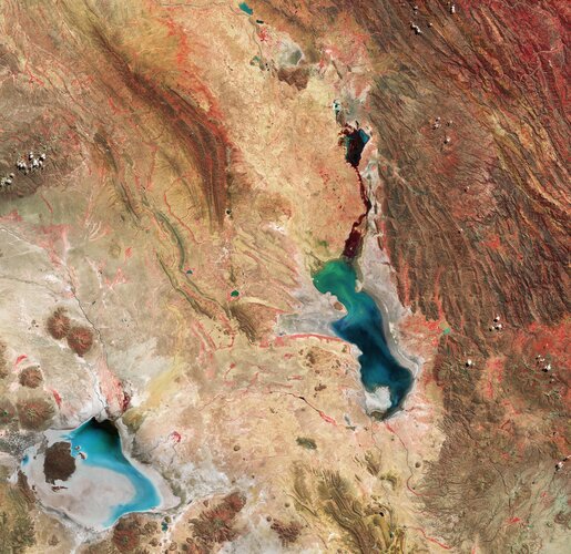
Acquired in April 2024, this false-colour image shows part of the Oruro Department towards the southern end of the Altiplano, a high plain that stretches almost 1000 km from Peru to Bolivia.
The image was processed using the near-infrared channel which highlights vegetation in red. As seen in the image, this part of the Altiplano is mostly arid with saline soils.
Some 40 000 years ago, this area was part of a giant lake that dried up, leaving behind two salt flats: Uyuni (not pictured) and Coipasa, visible in grey and light blue in the bottom-left corner. It also left behind two lakes: Poopó, the larger water body near the centre of the image, and Uru Uru, just above Poopó.
Lake Poopó is a saline lake and covers approximately 1000 sq km. It is an endorheic basin, which means water is lost through evaporation.
However, the lake’s shallow nature, with an average depth of just 3 m, has made its water level very sensitive to fluctuations. This is clear to see in the image, as part of the lakebed surrounding the water appears grey and dry. In the last decades, the lake has fully evaporated on some occasions, with catastrophic consequences for the region’s flora and fauna and for the economy.
The lake’s main tributary, the Desaguadero River, is visible north of the lake, dyeing its blue waters in different hues of green.
North of Poopó, the Uru Uru Lake’s mostly red surface indicates the presence of vegetation populating its shallow waters.
With its frequent revisits over the same area and high-resolution cameras working in 13 spectral bands, Copernicus Sentinel-2 can be used to monitor pollution in lakes, measure changes in their water levels and detect differences in sparsely vegetated areas, as well as the mineral composition of soil.