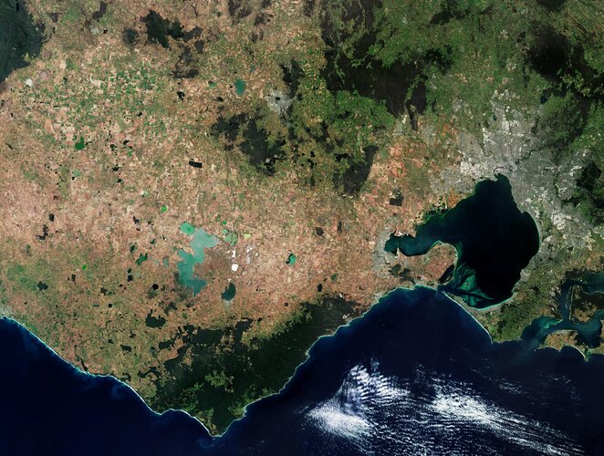
This Copernicus Sentinel-2 image features part of Victoria, a state in southeast Australia. Melbourne, Victoria’s capital, is visible in the right of the image.
Zoom in to explore this image at its full 10 m resolution or click on the circles to learn more.
From mountain peaks to dense rainforest gullies and dramatic coastlines, Victoria is home to a rich variety of landscapes. A number of national parks can be seen in dark green in the top of the image, while the brownish terrain of the Western Volcanic Plains can be seen in the left.
The Western Volcanic Plains is largely a flat, open plain, dotted with volcanic cones and maars, as well as lakes and swamplands. Lakes in the image appear in different colours, ranging from various shades of green to white, depending on the mineral concentration of their waters.
Lake Corangamite, Australia's largest permanent saltwater lake, is visible near the centre of the image, while Lake Beeac can be seen with its milky-white waters.
Thanks to its volcanic origin, the plain has some of the most fertile soils in Victoria and is generally used for agricultural purposes. A patchwork of agricultural fields can be seen scattered across the region.
The largest inlet along the coastline is Port Phillip Bay which opens into the Bass Strait through a short, narrow channel. It is bounded by the Bellarine Peninsula to the west and the Mornington Peninsula to the east.
Different shades of green in the bay either denote shallow waters — the average depth of the bay is 8 m — or sediment and dispersed particles that remain trapped before eventually flowing into the ocean.
The city of Melbourne sits at the head of Port Philip Bay. The Yarra River can be seen as a dark, winding line in the image, as it reaches Greater Melbourne before emptying into Port Philip Bay.
To the east of Port Phillip lies Western Port Bay which is dominated by French Island and Phillip Island.


 Image:
This Copernicus Sentinel-2 image features part of Victoria, a state in southeast Australia.