

 Image:
The historic centre of Vienna, Austria’s capital city, is featured in this image captured on 23 June 2023.
Image:
The historic centre of Vienna, Austria’s capital city, is featured in this image captured on 23 June 2023. The historic centre of Vienna, Austria’s capital city, is featured in this image captured on 23 June 2023.
Zoom in to explore this image at its full resolution or click on the circles to learn more.
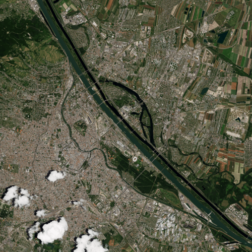
Vienna lies in the northeastern corner of Austria and straddles the famous Danube River, visible running across the top of the image. On the left shore of the Danube, a stretch of the river can be seen forming the Danube Canal, which flows through the city parallel to the main river.
The resulting island hosts the city’s chief park, the Prater, visible as a large green area. The park comprises various leisure facilities, including a renowned amusement park. Its attractions, such as the famous Giant Ferris Wheel, are clear to see when zooming into the north of the park.
Left of the Danube Canal lies the Innere Stadt, home to most of the city’s famous structures. Their green rooftops can be easily spotted exploring this area at full resolution.
The iconic St. Stephen’s Cathedral, one of the chief Gothic buildings of Europe, stands out in the centre, with the baroque Church of St. Peter to its west. The vast complex of buildings and courtyards of the Imperial Palace, the Hofburg, lies immediately southwest. South of the Palace, the rooftop of the magnificent Vienna State Opera House shows up, while on the opposite side we can pinpoint the Burgtheater, facing the City Hall building.
This image was acquired by the Pléiades Neo mission, a very high-resolution optical constellation, that pictures Earth with a resolution of up to 30 cm. Very high-resolution images are used in several sectors, including urban mapping, disaster response, insurance, infrastructure monitoring and agriculture.
Illustrating the unique contribution that Earth observing satellites offer to understand our planet, a collection of satellite images is showcased in a new permanent exhibition, that opened this week at the Vienna Museum of Science and Technology. The exhibition, supported by ESA, focuses on climate and aims to present the causes and connections of the climate crisis.