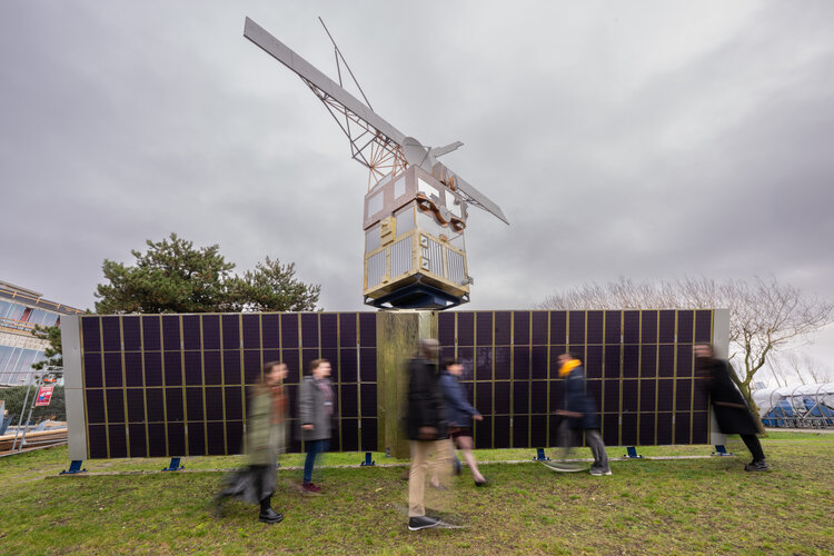
Every day the men and women of ESA’s technical heart head to work past this 1:1 model of pioneering Earth observation satellite, European Remote Sensing Spacecraft-2, ERS-2. Launched in 1995, the real-life ERS-2’s mission ended in 2011 and it is now due to reenter Earth’s atmosphere.
ERS-2 followed on from ERS-1 in 1991. The pair were Europe’s first microwave radar satellites, able to acquire images of Earth’s land and sea surfaces through clouds and darkness.
They also each carried a radar altimeter that charted land contours and sea and ice surface height, a radiometer for sampling sea surface temperature and atmospheric water vapour as well as a scatterometer able to map wind speed over the ocean based on radar backscatter patterns. In addition, ERS-2 carried a new ozone-mapping instrument.
ERS-2, like its predecessor, underwent its test campaign for launch at ESA’s ESTEC Test Centre in Noordwijk, the Netherlands. Marking the connection, this full-sized model of the satellite was erected near the establishment’s entrance.
In this photo, ERS-2’s radar antennas can be seen at the top of the model – the two diagonally oriented antennas and the small and large straight antennas below them. Its radar altimeter is the circular antenna below the largest radar array. Its ATSR-2 radiometer is located right of the radar altimeter, while its scatterometer projects from the satellite’s right side. ERS-2’s Global Ozone Monitoring Experiment, GOME, is located directly below the scatterometer (not in view). At the base of the model is ERS-2’s 12 m-long solar array.
During their lifetimes, the satellites circled Earth over 120 000 times in total, continuously observing and monitoring our planet’s land, atmosphere, oceans, and ice caps. Later versions of ERS instruments flew aboard ESA’s follow-on Envisat mission and then Europe’s Copernicus Sentinels fleet,which has become the world’s leading source of environmental data.
Placed into an approximate 800 km altitude Sun-synchronous orbit by an Ariane 4 launcher, ERS-2 operated for 16 years. In September 2011 its mission ended. ERS-2’s remaining fuel was used by mission controllers to lower its orbital altitude down to 573 km, to hasten the time it went take to reenter the atmosphere. This was done to reduce the risk of any adverse impact on the space environment. During reentry, the satellite will break up into pieces, the majority of which will burn up. The risks associated with satellite reentries are very low.
ESA introduced its initial space debris mitigation policy in 2008, which has subsequently been updated several times. As a consequence the Agency's missions in Earth orbit are now increasingly designed to conduct controlled reentries at the end of their life that allow operators to accurately target over which region on Earth they reenter. However, ESA continues to make efforts to dispose of its older satellites (such as ERS-2, Aeolus, Cluster and Integral) in more sustainable ways than were originally planned.
Follow the latest updates on ERS-2’s reentry here. Read more about the successes and legacy of the ERS-2 mission here.


 Image:
Saying goodbye to ERS-2