

 Image:
This wide view from the Copernicus Sentinel-3 mission captures an algae bloom around the Falkland Islands in the South Atlantic Ocean.
Image:
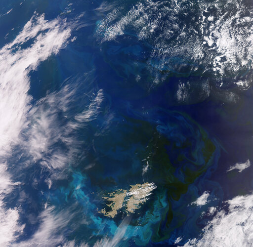
This wide view from the Copernicus Sentinel-3 mission captures an algae bloom around the Falkland Islands in the South Atlantic Ocean. This wide view from the Copernicus Sentinel-3 mission captures an algae bloom around the Falkland Islands (Islas Malvinas) in the South Atlantic Ocean.
Zoom in to explore this image at its full resolution or click on the circles to learn more.
Algae in the South Atlantic often quickly develop into enormous blooms which float and are carried with the meandering ocean currents. In this image, captured in November 2023, impressive green and blue swirls covering more than 360 000 sq km can be seen around the islands. The different colours are the result of sunlight reflecting off the chlorophyll contained in the microscopic plants.
Blooms in this area are quite common owing to the convergence of two strong oceanic currents: the warmer low-nutrient current from Brazil flowing southward and the colder Falkland current that travels northward. When the two currents meet, the resulting turbulence causes upwelling, which can drive large amounts of nutrients to the surface, which is partly responsible for phytoplankton blooms. These blooms are an important food source for many marine species.
The islands lie around 500 km northeast of the southern tip of South America, and comprise two main islands, West and East Falkland, and hundreds of smaller islands and islets that cover a land area that totals around five times that of Luxembourg.
Their landscape comprises mountain ranges, flat plains, rugged coastlines and cliffs. Hills run east-west across the northern parts of the two main islands, with the highest points being Mount Adam on West Falkland and Mount Usborne on East Falkland.
Helping to map algal blooms and providing critical information for marine operations are just some of the ways that the two Sentinel-3 satellites are used for Europe’s Copernicus programme. Carrying a suite of cutting-edge instruments, Copernicus Sentinel-3 measures systematically Earth’s oceans, land, ice and atmosphere to monitor and understand large-scale global dynamics.