

 Image:
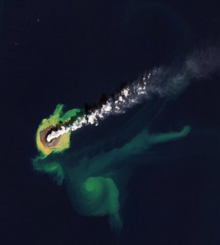
This Copernicus Sentinel-2 image features the Japanese island of Nishinoshima, in the northwest Pacific Ocean.
Image:
This Copernicus Sentinel-2 image features the Japanese island of Nishinoshima, in the northwest Pacific Ocean. This Copernicus Sentinel-2 image features the Japanese island of Nishinoshima, in the northwest Pacific Ocean.
Zoom in to explore this image at its full 10 m resolution or click on the circles to learn more.
One of the Ogasawara Islands, Nishinoshima is a small uninhabited volcanic island roughly 1000 km south of Tokyo. Volcanic activity along the western edge of the Pacific Ring of Fire gave rise to this island, which is in fact the tip of a submerged volcano.
Until 1974, only a part of the ridge of the otherwise submerged caldera was visible, and the island was about 700 m long and 200 m wide. Since then, Nishinoshima has experienced alternating periods of explosive activity and calm, but lava from various eruptions over the years has led to the island growing bigger.
This image was acquired in January 2021 and here the island is around 2.3 km in the north-south direction and 2 km in the east-west direction.
The yellowish discolouration of the water around the island is due to volcanic minerals, gas and seafloor sediment that is being stirred up by the volcanic activity. It stretches for about 10 km to the southeast, where ocean currents turn it into bright green swirls.
A plume of gas and steam can be seen rising from the volcano and drifting northeast over the Pacific Ocean. As the plume rises higher, the steam condenses and forms clouds.
Volcanic plumes are of particular concern to the airline industry because ash can contaminate oxygen supplies and damage jet engines. Atmospheric sensors on satellites can identify the gases and aerosols released by eruptions, quantify their wider environmental impact and can help provide early warnings to the aviation industry.
Satellite data can also be used to better understand volcanic activity. Optical and radar instruments can image lava flows, mudslides, ground fissures and earthquakes, and be used to assess damage.