

 Image:
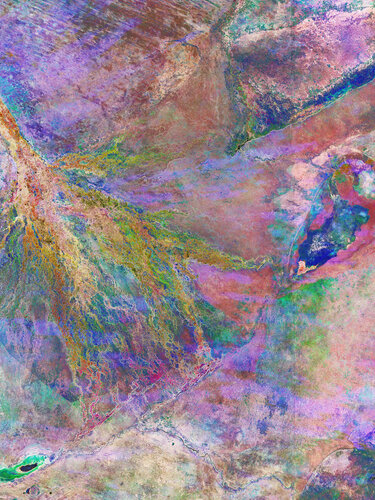
Botswana’s Okavango Delta – the world’s largest inland delta – is featured in this multitemporal radar image, captured by the Copernicus Sentinel-1 mission.
Image:
Botswana’s Okavango Delta – the world’s largest inland delta – is featured in this multitemporal radar image, captured by the Copernicus Sentinel-1 mission. Botswana’s Okavango Delta – the world’s largest inland delta – is featured in this multitemporal radar image, captured by the Copernicus Sentinel-1 mission.
Zoom in to explore this image at its full resolution or click on the circles to learn more about the features in it.
The delta is fed by the Okavango River, which is often referred to as ‘the river that never reaches the sea’. This is because, unlike most rivers, its direction of flow is inland. Instead of flowing towards the sea, the Okavango River irrigates the Kalahari Desert.
The Okavango Delta is a labyrinth of lagoons, swamps, channels and islands. It is a UNESCO World Heritage Site and part of the Ramsar wetland network. Wetlands are the most biologically diverse ecosystems on Earth, even more productive than tropical rainforests.
Wetlands can be difficult to access, but satellite observations from space can provide information on types of vegetation and water bodies, and how they change over time. Images acquired by satellites carrying radar instruments, such as Sentinel-1 are particularly useful, as they can be used to differentiate between dry and waterlogged surfaces, and show how wetlands change with the seasons.
This composite combines three Copernicus Sentinel-1 radar images, acquired over eight months in 2021. Each acquisition has been given a different colour – red for January, green for April and blue for August – to show how the land and water changed between acquisitions.
The shades of pink and blue in the lower part of the delta depict the seasonal changes in vegetation occurring along the waterways. The same goes for the Mababe depression, visible on the right side of the delta as an area with the same colouring.
In the bottom left of the image, Lake Ngami appears in dark colours, as its calm waters reflect the radar signal in all of the acquisitions. The green tones around it mean that the area around the lake is subject to seasonal flooding.