Hundreds of residents and tourists have been evacuated from the east Aegean island of Lesbos (also known as Lesvos), Greece, after a wildfire broke out on the morning of 23 July. The fire, which has been raging near the coastal area of Vatera, a popular tourist destination, has burned pine forest, shrubland and cultivated fields.
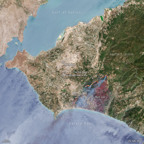
Captured on 24 July, this Copernicus Sentinel-2 image shows the active fire front which stretches for more than four km. Thick billowing smoke is visible in the image blowing in a southwest direction. The burn scars left across the land can be identified as a reddish-brown colour and cover an area of around 1700 hectares.
Fifty firefighters along with nine firefighting aircraft are working to extinguish the blaze, along with volunteers and military personnel. In response to the wildfire, the Copernicus Emergency Mapping Service was activated. The service uses satellite observations to help civil protection authorities and, in cases of disaster, the international humanitarian community, respond to emergencies.
Greece, along with many other countries in Europe, has been experiencing a prolonged heatwave with many parts of the country under fire alert. Over 300 firefighters and six aircraft are also trying to contain a wildfire currently burning in Greece’s Dadia National Park, Greece’s biggest Natura 2000 site, known for its black vulture colony.


 Image:
Hundreds of residents and tourists have been evacuated from the Greek island of Lesbos after a wildfire broke out on the morning of 23 July. This image, captured by Sentinel-2, shows the active fire front which stretches for more than four km.