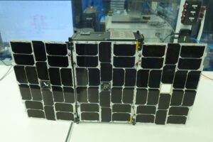
The CICERO-2 satellites will continue to collect GNSS radio occultation data, but will also receive GNSS signals reflected off the Earth to measure ocean winds, soil moisture and other surface conditions. NASA’s Cyclone Global Navigation Satellite System (CYGNSS), a set of eight smallsats launched in 2016, demonstrated that technology for studying tropical weather systems. The satellites will also be able to measure heavy precipitation through a technique called polarimetric radio occultation, again using GNSS signals.
“All this is based on essentially one instrument in slightly different forms,” Alex Saltman, chief executive of GeoOptics, said in an interview. “By using that universal instrument, our observations are software defined rather than hardware defined.”
While using a universal instrument, there will be some customization of the satellites. “Each satellite will likely make multiple measurements, but not all,” he said, depending on factors such as their orbits. While the original CICERO satellites were 6U cubesats, the new satellites will be a mix of 6U and 12U cubesats, with a few possibly larger.
The first CICERO-2 satellites will launch in early 2022, with more to follow later in the year. The long-term goal is to launch about 50 over five years.
Later satellites may carry additional instruments. GeoOptics is working on a radar instrument to measure ocean winds and other surface properties. That instrument, being developed with support from the National Oceanographic Partnership Program, could be ready for flight by the end of 2023, Saltman said. “The radar instrument is going to be a real workhorse for a wide variety of measurements, both government and commercial applications.”
The company is also working on an approach to use smallsats to map the Earth’s gravitational field, much like the Gravity Recovery and Climate Experiment (GRACE) and the GRACE Follow On missions, which measure mass change linked to water movement. The Earth science decadal survey published in early 2018 recommended NASA pursue a successor to GRACE Follow On.
That system, he said, would be developed in conjunction with NASA to implement the decadal recommendation, and the company has won NASA technology contracts for early-stage work on the concept. “We have an instrument design and we’re doing all the other work to prove out how the constellation would work.”
Saltman said GeoOptics has sufficient funding to begin deployment of CICERO-2 satellites. Later satellites may be funded through some combination of cash flow or additional investment.
GeoOptics expects revenues to come from a mix of government and commercial customers. In addition to potential NASA Earth science business, the company has a contract with the National Oceanic and Atmospheric Administration to provide GNSS radio occultation data for weather forecasting.
“CICERO-2 is designed to help provide high-priority NOAA climate and weather monitoring observations,” Conrad Lautenbacher, executive chairman of GeoOptics and a former NOAA administrator, said in a statement. “It can also play a key role in supporting crucial Defense Department satellite weather data requirements.”
The company also sees interest from commercial customers, such as Climavision, which is including GeoOptics data in forecasts it develops for customers in various industries. “We’re working with them to create weather forecasts for high-leverage customers, such as delivery companies and airlines, that need the absolute best forecasts,” Saltman said. “We’re seeing a lot of excitement in the marketplace for that product.”
“Government markets are important, but they move slowly,” he said. “Commercial markets are perhaps less sophisticated to start with, but they’re also where a lot of the long-term growth is.”


