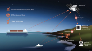
Horizon Space Technologies, a recently established subsidiary of Berkshire, England-based Horizon Technologies, is prime contractor for the U.K. government’s cubesat signals intelligence program called IOD-3 Amber.
Amber IOD-3, its first satellite, is part of the In-Orbit Demonstration (IOD) program run by government-backed nonprofit Satellite Applications Catapult.
With funding from the U.K. government’s innovation agency, the Amber IOD-3 cubesat is being built by AAC Clyde Space to provide data for the country’s National Maritime Information Centre (NMIC). L3Harris Technologies is assisting with the payload’s development.
The satellite is slated to launch aboard a SpaceX Cargo Dragon mission in August for deployment from the International Space Station shortly after arrival. Houston-based NanoRacks arranged for the cubesat’s deployment from the ISS.
More satellites incoming
Horizon Technologies CEO John Beckner told SpaceNews the company has secured funds to launch two more Amber satellites next year, amid plans for an initial constellation of six satellites.
Beckner declined to discuss the size of Horizon’s Series A funding round, which was led by private equity firm Maven Capital Partners. An industry source said it is in the “single-digit millions of dollars.”
Virgin Group founder Richard Branson’s financial services firm Virgin Money participated in the round through its Clydesdale Bank lender. Virgin Orbit, Branson’s air-launch rocket startup, has been investing in other space ventures in return for launch agreements.
The British government aims to use Horizon’s data to counter activities ranging from illegal fishing to human trafficking across its coastal waters.
“The Amber program to date has been an excellent example of a successful public/private partnership,” Beckner said.
“We are thrilled to have received so much support from the U.K. government, and this includes the [innovation accelerator] Catapult, Department for International Trade (DIT) and Defence & Security Organisation (DSO). Their help has simply been invaluable.”
Tracking the untracked
All passenger ships and most ocean-going vessels above a certain tonnage are required by law to be fitted with Automatic Identification Systems (AIS) transponders, enabling them to be tracked by coastal stations and satellites equipped with AIS receivers. However, ships can deactivate AIS transponders to avoid detection.
Horizon’s satellites will supplement AIS data by picking up faint electronic signals from navigation radars and satellite phones, enabling the tracking of vessels even if they turn off AIS.
The company will buy AIS data from third parties that will feed into its ground station. Becker said its satellites will have AIS receivers to double-check measurements, but it does not plan to sell this service.
The market for radio-frequency mapping (RFM) networks has been expanding in recent years, with venture capital investors helping to expand the number of players and satellites in orbit.
U.S.-based HawkEye 360 currently provides RFM services with six in-orbit satellites, saying in April that it raised an extra $55 million to complete its constellation with nine additional satellites.
Horizon’s technology builds off an L-band satellite-phone detection system called FlyingFish, which the company already sells to governments that operate it from crewed and uncrewed aircraft.
The company recently split into two business segments, hardware-based Horizon Aerospace Technologies and data-based Horizon Space Technologies, after FlyingFish helped it report more than 4.5 million British pounds ($6.4 million) in sales for 2020.
As well as launching satellites, Beckner said Horizon’s Series A funding enables it to hire new personnel and cover research and development for expanded features, supporting software payload upgrades for Amber IOD-3 and beyond.
He said the signals it picks up are demodulated to provide government end-users with intelligence data, ranging from radar “fingerprints” to satellite phones’ GPS locations.
Six satellites will enable worldwide coverage with latency under one hour.
Rapidly expanding market
Three other companies, all founded in the last six years, have been raising capital to deploy commercial RFM networks. These are U.S.-based Aurora Insight, Luxembourg’s Kleos Space and Unseenlabs of France.
“Demand for radio frequency sensing and monitoring by U.S. and international government organizations has continued to grow rapidly in recent years, with no signs of slowing down,” said Nicolo Dona dalle Rose, engagement director in boutique management consulting firm Avascent’s space practice.
“Defense and intelligence agencies will likely remain the core consumers of this data for the near future. However, appetite is rapidly expanding among commercial customers as well. Early movers in this space have an opportunity to shape the way in which data is consumed and the service is delivered.”
Unseenlabs said April 27 it raised a 20 million euro ($25 million) Series B round for its radio-frequency geolocation constellation.
The venture launched its first satellite in August 2019, and aims to deploy between 20 and 25 of them by 2025 to expand its services.
BRO-1, its first satellite, was still operational in November when Unseenlabs announced the launch of two more spacecraft: BRO-2 and BRO-3.
It plans to enable full coverage of the globe and a half-hour revisit time by growing its constellation.
Kleos Space raised $13.8 million following the Nov. 7 launch of its first cluster of four radio-frequency mapping satellites, providing daily coverage of the Earth.
The venture, which says on its website that revisit times are dependent on the specific area of interest, is funded to launch four more satellites toward the end of 2021. It is planning ten four-satellite clusters in total.
Beckner was coy about future plans but confirmed Horizon’s Amber constellation would be growing in the future.
He said work would begin soon on securing additional funding as Horizon accelerates its deployment of cubesats.
The company has also started looking for partners to combine its space-based data with tower-based systems, providing 24/7 coverage of critical maritime choke points, as well as UAVs for full-motion video to support legal proceedings.


