

 Image:
Stretches of land across New South Wales, Australia, have been hit with torrential rain leading to record-breaking floods. Data from the Copernicus Sentinel-1 mission are being used to map flooded areas to help relief efforts.
Image:
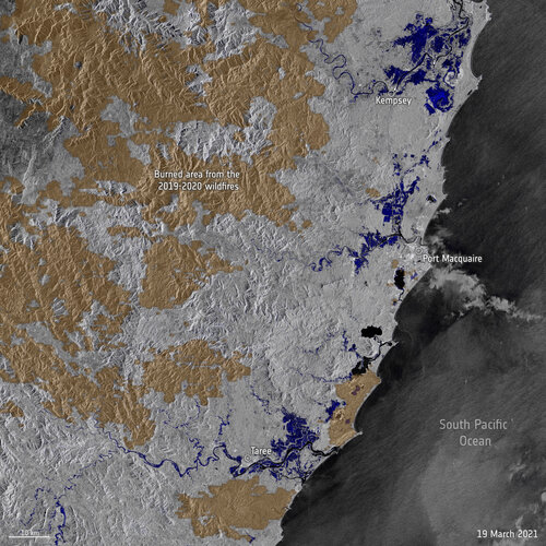
Stretches of land across New South Wales, Australia, have been hit with torrential rain leading to record-breaking floods. Data from the Copernicus Sentinel-1 mission are being used to map flooded areas to help relief efforts. Stretches of land across New South Wales, Australia, have been hit with torrential rain leading to record-breaking floods. The heavy rainfall has caused dams to spill over, rives to burst their banks and thousands of people forced to evacuate their homes. Data from the Copernicus Sentinel-1 mission are being used to map flooded areas to help relief efforts.
This radar image uses information from two separate images captured by the Sentinel-1 mission on 7 and 19 March highlighting flooded areas in dark blue and urban areas in light grey. Many of these areas affected by the record-breaking floods were ravaged by wildfires during Australia’s bushfire season in 2019. Large swaths of bushland and grazing country were scorched black by the blazes, with patches of burned land visible in light brown in the image.
Images acquired before and after flooding offer immediate information on the extent of inundation and support assessments of property and environmental damage. Copernicus Sentinel-1’s radar ability to ‘see’ through clouds and rain, and in darkness, makes it particularly useful for monitoring floods.
Data from the Copernicus Sentinel-1 mission have been used by the Copernicus Emergency Mapping Service, activated on 20 March, to map the flooded areas. The service provides information for emergency response to different types of disasters, including meteorological hazards, geophysical hazards, deliberate and accidental man-made disasters and other humanitarian disasters, as well as prevention, preparedness, response and recovery activities.