

 Image:
Italy’s Mount Etna, one of the world’s most active volcanoes, has erupted twice in less than 48 hours, spewing a fountain of lava and ash into the sky. This Copernicus Sentinel-2 image has been processed to show the lava flow in bright red.
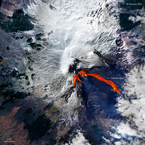
Image:
Italy’s Mount Etna, one of the world’s most active volcanoes, has erupted twice in less than 48 hours, spewing a fountain of lava and ash into the sky. This Copernicus Sentinel-2 image has been processed to show the lava flow in bright red. Italy’s Mount Etna, one of the world’s most active volcanoes, has erupted twice in less than 48 hours, spewing a fountain of lava and ash into the sky. This image, captured yesterday 18 February 2021 at 09:40 GMT by the Copernicus Sentinel-2 mission, has been processed using the mission’s shortwave-infrared band to show the lava flow in bright red.
After Etna’s powerful eruption on Tuesday 16 February, the volcano produced another spectacular display of fire – with tall lava fountains shooting into the night sky, reaching heights of around 700 m. The first eruption caused large lava flows to descend eastwards into the Valle del Bove, travelling for approximately 4 km, but the second major explosion on Thursday 18 caused the lava also to run for about 1.3 km down the volcano’s southern flanks.
Ash from the eruptions covered the city of Catania and authorities have been monitoring developments in the nearby towns at the base of the volcano, including Linguaglossa, Fornazzo and Milo. The eruption also forced the temporary closure of Sicily’s Catania Airport, which often happens when the volcano is active.
According to Volcano Discovery, which publishes frequent alerts about seismic activity, the volcano also saw activity earlier today, 19 February, with lava flows continuing to descend to the south and east. Mount Etna is the tallest active volcano in Europe and frequently erupts.
Satellite data can be used to detect the slight signs of change that may foretell an eruption. Once an eruption begins, optical and radar instruments can capture the various phenomena associated with it, including lava flows, mudslides, ground fissures and earthquakes. Atmospheric sensors on satellites can also identify the gases and aerosols released by the eruption, as well as quantify their wider environmental impact.