

 Image:
Competitors of the Vendée Globe sailing race are now nearing the finishing point, but while they were near the treacherous iceberg-infested waters of the Southern Ocean they remained relatively safe thanks to satellite observations.
Image:
Competitors of the Vendée Globe sailing race are now nearing the finishing point, but while they were near the treacherous iceberg-infested waters of the Southern Ocean they remained relatively safe thanks to satellite observations. After almost three months at sea, competitors of the Vendée Globe sailing race are now nearing the finishing point back in France, but while they were near the treacherous iceberg-infested waters of the Southern Ocean they remained relatively safe thanks to satellite observations. Read: Copernicus satellites keep eyes on icebergs for Vendée Globe
To ensure their safety, CLS, a subsidiary of the French CNES space agency, and CNP used information from satellites to detect and monitor icebergs. This information comes from satellites carrying altimeters, as well as those carrying synthetic aperture radar (SAR) such as Copernicus Sentinel-1. Satellites are the only way of detecting and monitoring icebergs effectively in the remote Southern Oceans.
Before the race started, this satellite information allowed CLS to establish an initial exclusion zone around Antarctica to keep sailors away from icebergs. Remarkably, they updated the zone no less than five times as the icy waters changed. These updates were provided to the Vendée Globe race organisers, who then communicated it to the skippers.
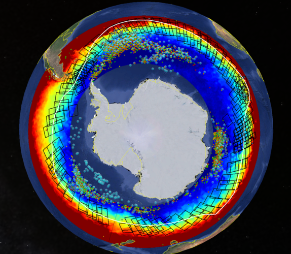
The image shows the main features of the clusters of icebergs detected with altimetry (coloured dots), Sentinel-1 wave mode (large cyan snowflakes) and Sentinel-1 synthetic aperture radar imagery (small blue snowflakes). These detections are plotted on a sea-surface temperature map. The image shows the extensive use of Sentinel-1 (black frames) during the Vendée Globe 2020–21, as well as the final version of the Antarctic Exclusion Zone (white line).
Read full story: Copernicus Sentinel-1 guides Vendée Globe sailors to safety