
Copernical Team
Astronomers witness the birth of a very distant cluster of galaxies from the early Universe
 Using the Atacama Large Millimeter/submillimeter Array (ALMA), of which ESO is a partner, astronomers have discovered a large reservoir of hot gas in the still-forming galaxy cluster around the Spiderweb galaxy - the most distant detection of such hot gas yet. Galaxy clusters are some of the largest objects known in the Universe and this result, published in Nature, further reveals just how earl
 Researchers create breakthrough spintronics manufacturing process that could revolutionize the electronics industry
 University of Minnesota Twin Cities researchers, along with a team at the National Institute of Standards and Technology (NIST), have developed a breakthrough process for making spintronic devices that has the potential to become the new industry standard for semiconductors chips that make up computers, smartphones, and many other electronics. The new process will allow for faster, more efficien
 SpaceX sends 56 Starlink satellites into low-Earth orbit
 SpaceX's 21st launch of the year sent 56 Starlink satellites into orbit from Cape Canaveral Space Force Station in Florida on Wednesday afternoon.
A Falcon 9 rocket lifted off at about 4 p.m., carrying 56 satellites into low-Earth orbit. The first stage booster successfully returned and landed on the "Just Read the Instructions" drone ship in the Atlantic Ocean about eight minutes after
SpaceX's 21st launch of the year sent 56 Starlink satellites into orbit from Cape Canaveral Space Force Station in Florida on Wednesday afternoon.
A Falcon 9 rocket lifted off at about 4 p.m., carrying 56 satellites into low-Earth orbit. The first stage booster successfully returned and landed on the "Just Read the Instructions" drone ship in the Atlantic Ocean about eight minutes after A Picture Perfect Day - Or To Be More Exact, a Day Perfect for Taking Pictures Sols 3783-3784
 Due to some delayed downlink of images, we didn't receive all the information we needed in time to do contact science today. Although the data did eventually arrive, it was too late to allow us to get the arm out for contact science.
Each planning day has a very strict timeline, in order to make our scheduled uplink time, which is MSL's allotted time for using the Deep Space Network to get
Due to some delayed downlink of images, we didn't receive all the information we needed in time to do contact science today. Although the data did eventually arrive, it was too late to allow us to get the arm out for contact science.
Each planning day has a very strict timeline, in order to make our scheduled uplink time, which is MSL's allotted time for using the Deep Space Network to get Redness of Neptunian asteroids sheds light on early Solar System
 Asteroids sharing their orbits with the planet Neptune have been observed to exist in a broad spectrum of red colour, implying the existence of two populations of asteroids in the region, according to a new study by an international team of researchers. The research is published in the journal Monthly Notices of the Royal Astronomical Society: Letters.
The team of scientists from the USA,
Asteroids sharing their orbits with the planet Neptune have been observed to exist in a broad spectrum of red colour, implying the existence of two populations of asteroids in the region, according to a new study by an international team of researchers. The research is published in the journal Monthly Notices of the Royal Astronomical Society: Letters.
The team of scientists from the USA, Scientists share 'comprehensive' map of volcanoes on Venus - all 85,000 of them
 Intrigued by reports of recent volcanic eruptions on Venus? WashU planetary scientists Paul Byrne and Rebecca Hahn want you to use their new map of 85,000 volcanoes on Venus to help locate the next active lava flow.
"This paper provides the most comprehensive map of all volcanic edifices on Venus ever compiled," said Byrne, an associate professor of earth and planetary sciences in Arts and
Intrigued by reports of recent volcanic eruptions on Venus? WashU planetary scientists Paul Byrne and Rebecca Hahn want you to use their new map of 85,000 volcanoes on Venus to help locate the next active lava flow.
"This paper provides the most comprehensive map of all volcanic edifices on Venus ever compiled," said Byrne, an associate professor of earth and planetary sciences in Arts and NASA, Boeing aiming for July launch of Starliner space capsule

The first crewed flight of Boeing's Starliner space capsule to the International Space Station (ISS) will take place in July, Boeing and NASA officials said Wednesday.
The CST-100 Starliner mission, which had previously been planned for April, will take place no earlier than July 21, the officials said.
"We've deliberated and decided that the best launch attempt is no earlier than July 21 for CFT," the crew flight test, Steve Stich, the manager of NASA's Commercial Crew Program, told reporters.
"We feel pretty confident with that date," added Mark Nappi, the Starliner program manager at Boeing.
Stich said more time was needed to certify the parachute system designed to bring the astronauts and the spacecraft safely back to Earth, and a ground test of the parachutes will be conducted in May.
Don't take batteries to the moon or Mars, 3D print them when you get there

When the Artemis astronauts and future explorers go to the moon and Mars, they'll need power. Lots of it. Of course, they'll use solar panels to generate the juice they need for habitats, experiments, rovers, and so on.
The Making of Juice – Episode 10.1
 Video:
00:12:07
Video:
00:12:07
The Making of Juice series takes the viewer behind the scenes of the European space industry, space technology and planetary science communities around ESA’s Jupiter Icy Moons Explorer (Juice) mission.
Juice has a state-of-the-art science payload comprising remote sensing, geophysical and in situ instruments. This episode focuses on the in situ instruments, which will study the particle, magnetic, radio and plasma environment in the Jupiter system.
A magnetometer (J-MAG) equipped with sensors will characterise the Jovian magnetic field and its interaction with that of Ganymede, and will study the subsurface oceans of the icy moon. The Particle Environment Package
Ariane 5 rocket for the Juice launch being transferred to final assembly
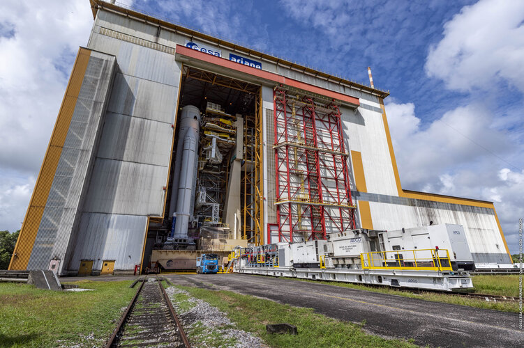 Image:
Ariane 5 rocket for the Juice launch being transferred to the final assembly building at Europe's Spaceport in French Guiana for payload integration and last preparation for flight VA260
Image:
Ariane 5 rocket for the Juice launch being transferred to the final assembly building at Europe's Spaceport in French Guiana for payload integration and last preparation for flight VA260