Displaying items by tag: simulation
Conform (GIS data processing)
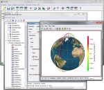
Conform is a software for cross-platform GIS viewer, editor and analysis tool.
GameSim, a video vame, simulation and GIS company, launches a new version of the Geospatial visualization product, Conform, which adds support for rendering LIDAR, point cloud data.
Conform is a powerful, easy-to-use tool for processing your GIS data. Whether you are a new or experienced GIS user, you will find Conform a useful tool to view, edit and analyze your data. Drag and drop folders of data into Conform and it will automatically load all supported GIS formats (e.g., Shapefiles, DTED, GeoTIFFs, LIDAR, etc.). Got a new batch of data that you need to take a look at? It's as simple as dragging the root folder into Conform and let it handle the rest.
Built for Speed
Using modern game engine rendering techniques, Conform will parse and display large amounts of data in moments. Many GIS tools require users to create separate projects when loading GIS data from various geographic locations and formats. This is not required in Conform. Users can load all of their data into a single project and use the intuitive map window to view all of their data across the globe.
Princeton Satellite Systems
Princeton Satellite Systems, Inc. is a company specializing in aerospace control and simulation technology.
Princeton Satellite Systems is actively developing state-of-the-art technology for launch vehicles and spacecraft navigation. The areas of expertise include control, estimation, optimization and simulation. The company has numerous government contracts.
Princeton Satellite Systems sells commercial software including control toolboxes for MATLAB™, stand-alone simulations, and software libraries for real-time software.
ASTOS
ASTOS is a Trajectory optimization and simulation tool for launch and re-entry missions, orbit transfers, design optimization and for re-entry safety assessments.
It solves Aerospace problems with a data driven interface and automatic initial guesses. Since 1989, the European Space Agency has developed, and improved this trajectory optimization environment to compute optimal trajectories for a variety of complex multi-phase Optimal control problems. ASTOS is being extensively used at ESA and aerospace industry community to calculate optimal launch and entry trajectories and was one of the tools used by ESA to assess the risk due to the ATV 'Jules Verne' re-entry. ASTOS is compatible with Windows, Linux and Mac OS platforms.
It is maintained and commercialized by ASTOS Solutions Gmbh for the European Space Agency.
Intespace
Intespace is a service and engineering company in Toulouse, France, providing a complete set of environment simulation test facilities in the domains of Space, Aeronautics and Defence.
It offers mechanical, acoustic, thermal and radio electric testing to European industrialists, allowing validation of systems and equipment prior to operational implementation.
(source: http://www.intespace.fr/english/page/home-page/1164-about-intespace.html)


