Displaying items by tag: satellite
XIPS - Xenon Ion Propulsion System
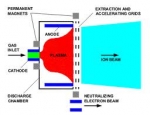
XIPS is a commercial electron bombardment thruster (also known as an electrostatic ion thruster) – a form ion propulsion – that is a product of Hughes Space and Communications Company, which, in 2000, became part of Boeing Satellite Systems.
XIPS (pronounced "zips") employs the heavy inert gas xenon as a propellant. It was first used operationally aboard the PAS-5 (PanAmSat-5) communications satellite in 1997 and has since been fitted to many other geosynchronous satellites for use primarily in station-keeping. In a XIPS, xenon atoms are injected into an ionization chamber and ionized by electron bombardment. The propellant is then electrostatically accelerated through a series of biased grids. Ions, ejected by XIPS, travel in a stream at a speed of 30 km/s (62,900 mph), nearly 10 times that of a conventional chemical thruster. The high efficiency of the system leads to a reduction in propellant mass of up to 90% for a satellite designed for 12–15 years operation.
For example on a XIPS equipped Boeing 702 satellite, four 25-cm thrusters provide economical station keeping, needing only 5 kg of fuel per year. Boeing asserts that this is "a fraction of what bipropellant or arcjet systems consume". Boeing further asserts, that a XIPS can be used for final orbit insertion and has orders( source: Wikipedia, Boeing_702 ) for spacecraft utilizing only ion thrusters. This conserves even more payload mass, as compared to using an on-board liquid apogee engine.
Boeing 702 satellite
The Boeing 702 satellite is a family of geostationnary satellites designed and manufactured by the company Boeing.
Its design requirements include lower cost and high reliability. It offers a broad spectrum of modularity. A primary example is payload/bus integration. After the payload is tailored to customer specifications, the payload module mounts to the common bus module at only four locations and with only six electrical connectors. This design simplicity confers advantages. First, nonrecurring program costs are reduced, because the bus does not need to be changed for every payload, and payloads can be freely tailored without affecting the bus. Second, the design permits faster parallel bus and payload processing. This leads to the third advantage: a short production schedule.
Further efficiency derives from the 702's advanced xenon ion propulsion system (XIPS), which was pioneered by Boeing. XIPS is 10 times more efficient than conventional liquid fuel systems. Four 25-cm thrusters provide economical stationkeeping, needing only 5 kg of fuel per year - a fraction of what bipropellant or arcjet systems consume. Using XIPS for final orbit insertion conserves more mass as compared to using an on-board liquid apogee engine. Customers can apply the weight savings to increase the revenue-generating payload, to prolong service life, or to change to a less expensive launch vehicle (when cost is based on satellite mass).
MSG - Meteosat Second Generation
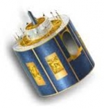
MSG, Meteosat Second Generation, is a serie of geostationary meteorological satellites operated by EUMETSAT.
It consists of a series of four geostationary meteorological satellites, along with ground-based infrastructure, that will operate consecutively until 2020. The MSG satellites carry a pair of instruments — the Spinning Enhanced Visible and InfraRed Imager (SEVIRI), which has the capacity to observe the Earth in 12 spectral channels and provide image data which is core to operational forecasting needs, and the Geostationary Earth Radiation Budget (GERB) instrument supporting climate studies.
It was designed in response to user requirements to serve the needs of Nowcasting applications and numerical weather prediction. In addition the GERB instrument provides important data for climate monitoring and research.
The MSG satellites are spin-stabilised like the previous generation, but with many design improvements. The more frequent and comprehensive data collected by MSG also aids the weather forecaster in the swift recognition and prediction of dangerous weather phenomena such as thunderstorms, fog and explosive development of small but intense depressions which can lead to devastating wind storms.
The MSG satellites are 3.2 m in diameter and 2.4 m high and spins anti-clockwise at 100 RPM at an altitude of 36,000 km.
On January 29, 2004 the first Meteosat Second Generation satellite MSG-1, renamed to Meteosat-8, commenced routine operations.
Astra (satellite)
Astra is the brand name for a number of geostationary communication satellites, both individually and as a group, which are owned and operated by SES S.A., a global satellite operator based in Betzdorf, in eastern Luxembourg. The name is also used to describe the pan-European broadcasting system provided by these satellites, the channels carried on them, and even the reception equipment.
SAOCOM
SAOCOM (SAtélite Argentino de Observación COn Microondas, Spanish for Argentine Microwaves Observation Satellite) is a planned Earth observation satellite series of the Argentine Space Agency CONAE. Two satellites are planned, SAOCOM 1A and SAOCOM 1B. Both will be equipped with a L-band full polarimetric Synthetic Aperture Radar (SAR). Originally launch was announced for 2010 (1A) and 2011 (1B), but later due to delays in satellites' development both launches were postponed to between 2012 and 2013. Further delays pushed the launches date back tentatively towards 2014 and 2015 respectively for 1A and 1B satellites. Those two satellites along with four X-band SAR equipped COSMO-SkyMed satellites from the Italian Space Agency ASI would conform the Italian-Argentine System of Satellites for Emergency Management (SIASGE) constellation.
SAC-D
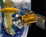
SAC-D (Spanish: Satelite de Aplicaciones Cientificas-D, meaning Satellite for Scientific Applications-D), also known as Aquarius after its primary instrument, is an Argentine Earth science satellite built by INVAP and launched on June 10, 2011. It carries seven instruments to study the environment, and a technology demonstration experiment.
Its primary instrument, Aquarius, was built by and is operated by the United States National Aeronautics and Space Administration.
SAC-D is operated by CONAE, the Argentine space agency. The satellite is expected to operate for five years; however the Aquarius instrument is only expected to operate for three.
Intelsat 28 / New Dawn
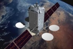
Intelsat 28, formerly New Dawn, is a communications satellite produced and run by Intelsat. It is positioned in geosynchronous orbit at 33 degrees east and serving TV and broadband communications to Africa.
It is based around the STAR-2 satellite platform.
Orbital Sciences Corporation
Orbital Sciences Corporation (OSC, though commonly referred to as Orbital) is an American company which specializes in the manufacturing and launch of satellites. Its Launch Systems Group is heavily involved with missile defense launch systems. Orbital formerly owned ORBIMAGE (now GeoEye) and the Magellan line of GPS receivers, though they are now divested (the latter toThales).
It has its headquarters in the Dulles area of unincorporated Loudoun County,Virginia, United States.
Orbital Sciences since inception has built 569 launch vehicles with 82 more to be delivered by 2015. 174 satellites have been built by the company since 1982 with 24 more to be delivered by 2015. Orbital has a 40% share of the interceptor market, 55% share of the small communications satellite market, and a 60% share of the small launch vehicles market. The company is expanding into the medium size launch vehicles and satellites market with the development of the Antares rocket and the acquisition of the General Dynamics Advanced Information System Satellite division.
Terra
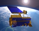
Terra (EOS AM-1) is a multi-national NASA scientific research satellite in a sun-synchronous orbit around the Earth.[1] It is the flagship of the Earth Observing System (EOS). The name "Terra" comes from the Latin word for Earth.
Launch
The satellite was launched from Vandenberg Air Force Base on December 18, 1999, aboard an Atlas IIAS vehicle and began collecting data on February 24, 2000.
Mission
Terra carries a payload of five remote sensors designed to monitor the state of Earth's environment and ongoing changes in its climate system:
- ASTER (Advanced Spaceborne Thermal Emission and Reflection Radiometer)
- CERES (Clouds and the Earth's Radiant Energy System)
- MISR (Multi-angle Imaging SpectroRadiometer)
- MODIS (Moderate-resolution Imaging Spectroradiometer)
- MOPITT (Measurements of Pollution in the Troposphere)
Data from the satellite helps scientists better understand the spread of pollution around the globe. Studies have used instruments on Terra to examine trends in global carbon monoxide and aerosol pollution. The data collected by Terra will ultimately become a new, 15-year global data set.
HETE
The High Energy Transient Explorer (abbreviated HETE; also known as Explorer 79) was an American astronomical satellite with international participation (mainly Japan and France). The prime objective of HETE was to carry out the first multiwavelength study of gamma-ray bursts with UV, X-ray, and gamma-ray instruments mounted on a single, compact spacecraft. A unique feature of the HETE mission was its capability to localize GRBs with ~10 arc second accuracy in near real time aboard the spacecraft, and to transmit these positions directly to a network of receivers at existing ground-based observatories enabling rapid, sensitive follow-up studies in the radio, IR, and optical bands. The satellite bus for the first HETE was designed and built by AeroAstro, Inc. of Herndon, VA; the replacement satellite, HETE-2, was built by MIT based on the original HETE design.
Launch attempts
The first HETE was lost during the launch on Nov.4, 1996. The Pegasus rocket achieved a good orbit, but explosive bolts releasing HETE from another satellite (Argentina's SAC-B) and from its DPAF envelope failed to charge, dooming both satellites. A battery on the third stage of the rocket and responsible for these bolts cracked during the ascent.
A second HETE satellite, HETE-2, was launched on October 9, 2000 in a follow-up mission. It was similar to the first HETE, but replaced the UV camera with an additional X-ray camera (Soft X-ray Camera or SXC) capable of higher localization accuracy than the original X-ray instrument (Wide-Field X-ray Monitor or WXM).

