
Copernical Team
Friday, 19 August 2022 11:48
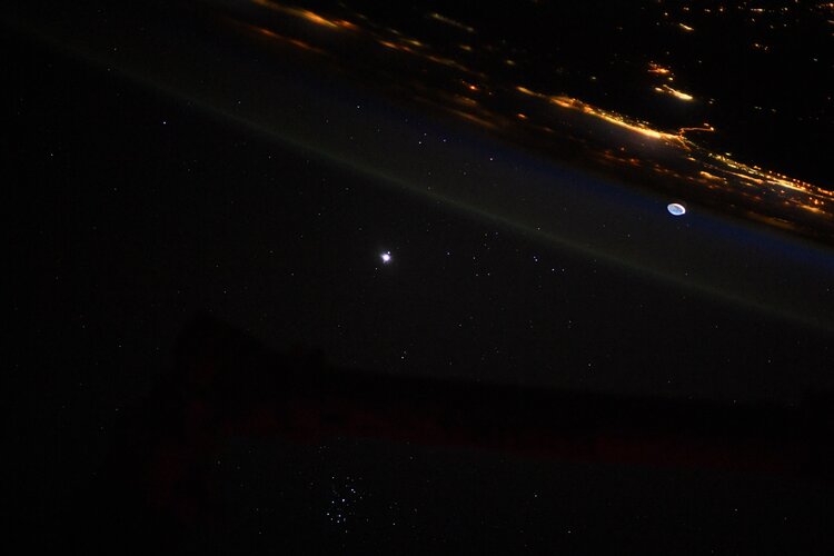
The Lacuna Space water monitoring system
Camarillo CA (SPX) Aug 19, 2022
 Semtech Corporation (Nasdaq: SMTC), a leading global supplier of high performance analog and mixed-signal semiconductors and advanced algorithms, announced a collaboration with New Zealand's IoT Ventures and global connectivity provider Lacuna Space.
IoT Ventures has used Semtech's LoRa devices to develop its Drought Early Warning System, a network of low-cost rainwater tank and rain monit
Semtech Corporation (Nasdaq: SMTC), a leading global supplier of high performance analog and mixed-signal semiconductors and advanced algorithms, announced a collaboration with New Zealand's IoT Ventures and global connectivity provider Lacuna Space.
IoT Ventures has used Semtech's LoRa devices to develop its Drought Early Warning System, a network of low-cost rainwater tank and rain monit
Published in
News
Tagged under
Friday, 19 August 2022 11:48
Launch Schedule for 3rd StriX-1 SAR satellite
Tokyo, Japan (SPX) Aug 19, 2022
 Synspective Inc., a SAR satellite data and analytic solutions provider, reports that the official launch schedule of StriX-1, the company's third SAR satellite.
StriX-1 has a launch window starting from mid-September (UTC). Exact lift-off target date and time will be confirmed soon.
Please note that the launch may be postponed or canceled due to unforeseen weather conditions or compl
Synspective Inc., a SAR satellite data and analytic solutions provider, reports that the official launch schedule of StriX-1, the company's third SAR satellite.
StriX-1 has a launch window starting from mid-September (UTC). Exact lift-off target date and time will be confirmed soon.
Please note that the launch may be postponed or canceled due to unforeseen weather conditions or compl
Published in
News
Tagged under
Friday, 19 August 2022 11:48
MariaDB reimagines how databases deliver geospatial capabilities with acquisition
Helsinki, Finland (SPX) Aug 19, 2022
 MariaDB Corporation has announced it has acquired CubeWerx, leaders in geospatial solutions, for an undisclosed amount. With the acquisition, MariaDB adds cloud-native, scalable geospatial capabilities that the company plans to offer through its fully managed cloud service MariaDB SkySQL. Applications that leverage geospatial data are truly transformative, enabling businesses to offer new produc
MariaDB Corporation has announced it has acquired CubeWerx, leaders in geospatial solutions, for an undisclosed amount. With the acquisition, MariaDB adds cloud-native, scalable geospatial capabilities that the company plans to offer through its fully managed cloud service MariaDB SkySQL. Applications that leverage geospatial data are truly transformative, enabling businesses to offer new produc
Published in
News
Tagged under
Friday, 19 August 2022 11:48
'Cannibal' solar burst headed for Earth could make northern lights visible in U.S.
Washington DC (UPI) Aug 18, 2021
 A plume of "dark plasma" from the sun is expected to be overtaken by a "cannibal" solar burst that may cause an aurora display visible throughout large portions of the United States on Thursday.
The first "dark plasma explosion" was first seen on Sunday after erupting from a sunspot on the sun's surface at a speed of 1.3 million mph, tearing through the sun's atmosphere and creating a c
A plume of "dark plasma" from the sun is expected to be overtaken by a "cannibal" solar burst that may cause an aurora display visible throughout large portions of the United States on Thursday.
The first "dark plasma explosion" was first seen on Sunday after erupting from a sunspot on the sun's surface at a speed of 1.3 million mph, tearing through the sun's atmosphere and creating a c
Published in
News
Tagged under
Friday, 19 August 2022 11:48
Orion Space Solutions team selected to lead US Space Force Tetra-5 mission
Louisville CO (SPX) Aug 19, 2022
 US Space Force (USSF) has awarded Orion Space Solutions a contract to develop three spacecraft in support of USSF's mission to advance and launch new technologies in space.
Working with partners Hera Systems, Inc. Booz Allen Hamilton Inc., and SCOUT Space Inc., Orion Space Solutions (OSS) brings together a diversified, highly capable team to build and deploy new satellites to geostationary
US Space Force (USSF) has awarded Orion Space Solutions a contract to develop three spacecraft in support of USSF's mission to advance and launch new technologies in space.
Working with partners Hera Systems, Inc. Booz Allen Hamilton Inc., and SCOUT Space Inc., Orion Space Solutions (OSS) brings together a diversified, highly capable team to build and deploy new satellites to geostationary
Published in
News
Tagged under
Friday, 19 August 2022 11:48
Vector Space Biosciences offers tools countering stressors during spaceflight
San Francisco CA (SPX) Aug 19, 2022
 To establish a lunar base or go to Mars, understanding how to protect and repair the human body during spaceflight is imperative. Countermeasures against diseases associated to stressors during spaceflight, such as microgravity and radiation, need to be developed quickly.
Vector Space Biosciences has developed a platform of computational solutions designed to accelerate the development of
To establish a lunar base or go to Mars, understanding how to protect and repair the human body during spaceflight is imperative. Countermeasures against diseases associated to stressors during spaceflight, such as microgravity and radiation, need to be developed quickly.
Vector Space Biosciences has developed a platform of computational solutions designed to accelerate the development of
Published in
News
Tagged under
Friday, 19 August 2022 11:48
Terran Orbital delivers LunIR to Cape Canaveral for Artemis 1 launch
Boca Raton FL (SPX) Aug 19, 2022
 Terran Orbital Corporation (NYSE: LLAP) has delivered LunIR to Complex 39B at NASA's Kennedy Space Center. LunIR is a 6U satellite that will fly by the Moon and collect surface thermography as a secondary payload on Artemis 1 - a test mission for NASA's Space Launch System (SLS).
Offering more payload mass, volume capability, and energy, SLS, the world's most powerful rocket to date, can c
Terran Orbital Corporation (NYSE: LLAP) has delivered LunIR to Complex 39B at NASA's Kennedy Space Center. LunIR is a 6U satellite that will fly by the Moon and collect surface thermography as a secondary payload on Artemis 1 - a test mission for NASA's Space Launch System (SLS).
Offering more payload mass, volume capability, and energy, SLS, the world's most powerful rocket to date, can c
Published in
News
Tagged under
Friday, 19 August 2022 11:48
Deep concern about food security in East Africa
Greenbelt MD (SPX) Aug 19, 2022
 The rains have failed in Eastern Africa for four consecutive seasons. That has not happened in 40 years of satellite records. Scientists and aid agencies are now alerting the world to an unprecedented level of food insecurity in 2022 for Ethiopia, Kenya, and Somalia. With forecasts suggesting the next rainy season will also be inadequate, climate and agriculture experts are advising governments
The rains have failed in Eastern Africa for four consecutive seasons. That has not happened in 40 years of satellite records. Scientists and aid agencies are now alerting the world to an unprecedented level of food insecurity in 2022 for Ethiopia, Kenya, and Somalia. With forecasts suggesting the next rainy season will also be inadequate, climate and agriculture experts are advising governments
Published in
News
Tagged under
Friday, 19 August 2022 12:04
Week in images: 15-19 August 2022
Week in images: 15-19 August 2022
Discover our week through the lens
Published in
News
Tagged under


