
Copernical Team
NASA's high-resolution air quality control instrument launches

A Falcon 9 rocket successfully blasted off from Florida into space on Friday carrying a new NASA device that can track air pollution over North America down to the neighborhood level.
The launch, which took place at 12:30 am (0430 GMT), will bring into orbit the Tropospheric Emissions Monitoring of Pollution (TEMPO) instrument, which will allow scientists to monitor air pollutants and their emission sources more extensively than ever before.
The data will be used by the US Environmental Protection Agency, the National Oceanic and Atmospheric Administration and other agencies responsible for tackling atmospheric pollution.
Smelly seaweed bloom heads to Florida

A large mass of Sargassum ‘seaweed’ circling around the Gulf of Mexico may soon wash up along the US west coast near Florida – depending on the right combination of currents and wind. The bloom, which may likely be the largest ever recorded, is so large that it’s visible from space.
Week in images: 03-07 April 2023

Week in images: 03-07 April 2023
Discover our week through the lens
Webb reveals new details in Cassiopeia A
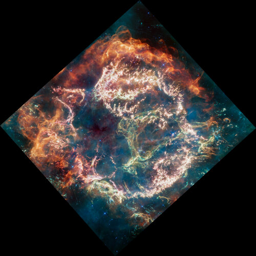
The explosion of a star is a dramatic event, but the remains that the star leaves behind can be even more dramatic. A new mid-infrared image from NASA’s James Webb Space Telescope provides one stunning example. It shows the supernova remnant Cassiopeia A (Cas A), created by a stellar explosion 340 years ago.
Makenzie Lystrup named first female director of Goddard Space Flight Center
 Makenzie Lystrup has been named the first female director of the Goddard Space Flight Center in Maryland, NASA announced Thursday.
Lystrup will begin serving in the role immediately, succeeding Dave Mitchell, who has resumed his role as the chief program management officer at NASA's headquarters in Washington, D.C., NASA said in a news release.
"Goddard is an incredible center an
Makenzie Lystrup has been named the first female director of the Goddard Space Flight Center in Maryland, NASA announced Thursday.
Lystrup will begin serving in the role immediately, succeeding Dave Mitchell, who has resumed his role as the chief program management officer at NASA's headquarters in Washington, D.C., NASA said in a news release.
"Goddard is an incredible center an Earth from Space: Seoul, South Korea
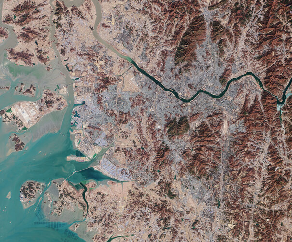 Image:
South Korea’s capital city, Seoul, and surroundings are featured in this image, captured by the Copernicus Sentinel-2 mission on 21 February 2023.
Image:
South Korea’s capital city, Seoul, and surroundings are featured in this image, captured by the Copernicus Sentinel-2 mission on 21 February 2023. Space-based NASA instrument to track pollution over North America
A Falcon 9 rocket successfully blasted off from Florida into space on Friday carrying a new NASA device that can track air pollution over North America down to the neighborhood level.
The launch, which took place at 12:30 am (0430 GMT), will bring into orbit the Tropospheric Emissions Monitoring of Pollution (TEMPO) instrument, which will allow scientists to monitor air pollutants and their emission sources more extensively than ever before.
The data will be used by the US Environmental Protection Agency, the National Oceanic and Atmospheric Administration and other agencies responsible for tackling atmospheric pollution.
Revealing invisible Himalaya glacier loss

New research reveals that ice being lost from glaciers that flow into lakes in the Himalayas has been significantly underestimated. This discovery has critical implications for predicting the demise of the region’s glaciers and for managing critical water resources.
Soyuz spacecraft that will bring ISS crew back to Earth moved to new port
 The Soyuz MS-23 spacecraft that will return three International Space Station crew members to Earth moved to a new docking port on the space station Thursday.
The three Expedition 69 crew members - NASA astronaut Frank Rubio and Roscosmos cosmonauts Sergey Prokopyev and Dmitri Petelin - successfully moved the spacecraft to the Prichal module on the Earth-facing side of the ISS at 5:22
The Soyuz MS-23 spacecraft that will return three International Space Station crew members to Earth moved to a new docking port on the space station Thursday.
The three Expedition 69 crew members - NASA astronaut Frank Rubio and Roscosmos cosmonauts Sergey Prokopyev and Dmitri Petelin - successfully moved the spacecraft to the Prichal module on the Earth-facing side of the ISS at 5:22 Axiom Space's upcoming ISS mission part of increasing commercialization of space
 NASA and Axiom Space announced the first possible launch date of the commercial Ax-2 Mission to the International Space Station on Thursday.
The SpaceX CRS-27 Dragon spacecraft is slated to launch from Launch Complex 39A at Kennedy Space Center in Florida on May 8 at 10:43 p.m. EST. Axiom Space hosted a mission overview press conference on Thursday to discuss the status of the mission.
NASA and Axiom Space announced the first possible launch date of the commercial Ax-2 Mission to the International Space Station on Thursday.
The SpaceX CRS-27 Dragon spacecraft is slated to launch from Launch Complex 39A at Kennedy Space Center in Florida on May 8 at 10:43 p.m. EST. Axiom Space hosted a mission overview press conference on Thursday to discuss the status of the mission. 


