Copernical Team
Voyager unveils dust-resistant coating tested on lunar surface
 Voyager Technologies (Voyager) has marked a milestone in lunar technology advancement with the arrival of its proprietary Clear Dust-Repellent Coating (CDRC) on the Moon. Delivered aboard Firefly Aerospace's Blue Ghost lander, the coating touched down on March 2 following nearly a month in transit.
"The number of surfaces on Earth that are coated by dust daily, affecting performance and vi
 Vast expands Haven-1 Lab partnerships with biotech and space science leaders
 Vast has added three new payload collaborators to its Haven-1 Lab: Japan Manned Space Systems Corporation (JAMSS), Interstellar Lab, and Exobiosphere. These companies will join the world's first commercial crewed microgravity research and manufacturing facility aboard Haven-1, which is on track for launch in May 2026 and approaching full utilization.
Each new partner brings a unique focus
 ESA School Days 2025 at ESRIN
 Video:
00:06:15
English
From 7 to 11 April, ESA's Centre for Earth Observation in Frascati, ESRIN, hosted the 2025 edition of ESA School Days, welcoming almost 1400 young students.
The event kicked off with primary school students (4th and 5th grades) visiting during the first three days, followed by secondary school students on the final two days.
Throughout the week, 35 schools from across Italy engaged in presentations and laboratories, delving into the diverse space activities conducted at ESA’s establishment.
This initiative, which included contributions from ESERO Italia and the Italian Space Agency (ASI), aims to inspire and engage the next generation of STEM
Earth from Space: Giza, Egypt
 Image:
This very high-resolution image captures the Egyptian city of Giza and its surrounding area, including the world-famous Giza Pyramid Complex.
 It's time to build a space telescope interferometer—this could be the first step
This request seems a bit unusual, so we need to confirm that you're human. Please press and hold the button until it turns completely green. Thank you for your cooperation!
Press and hold the button
If you believe this is an error, please contact our support team.
185.132.36.159 : e8c297bb-f638-4489-b701-6f174a6d
Sea surface warming faster than expected
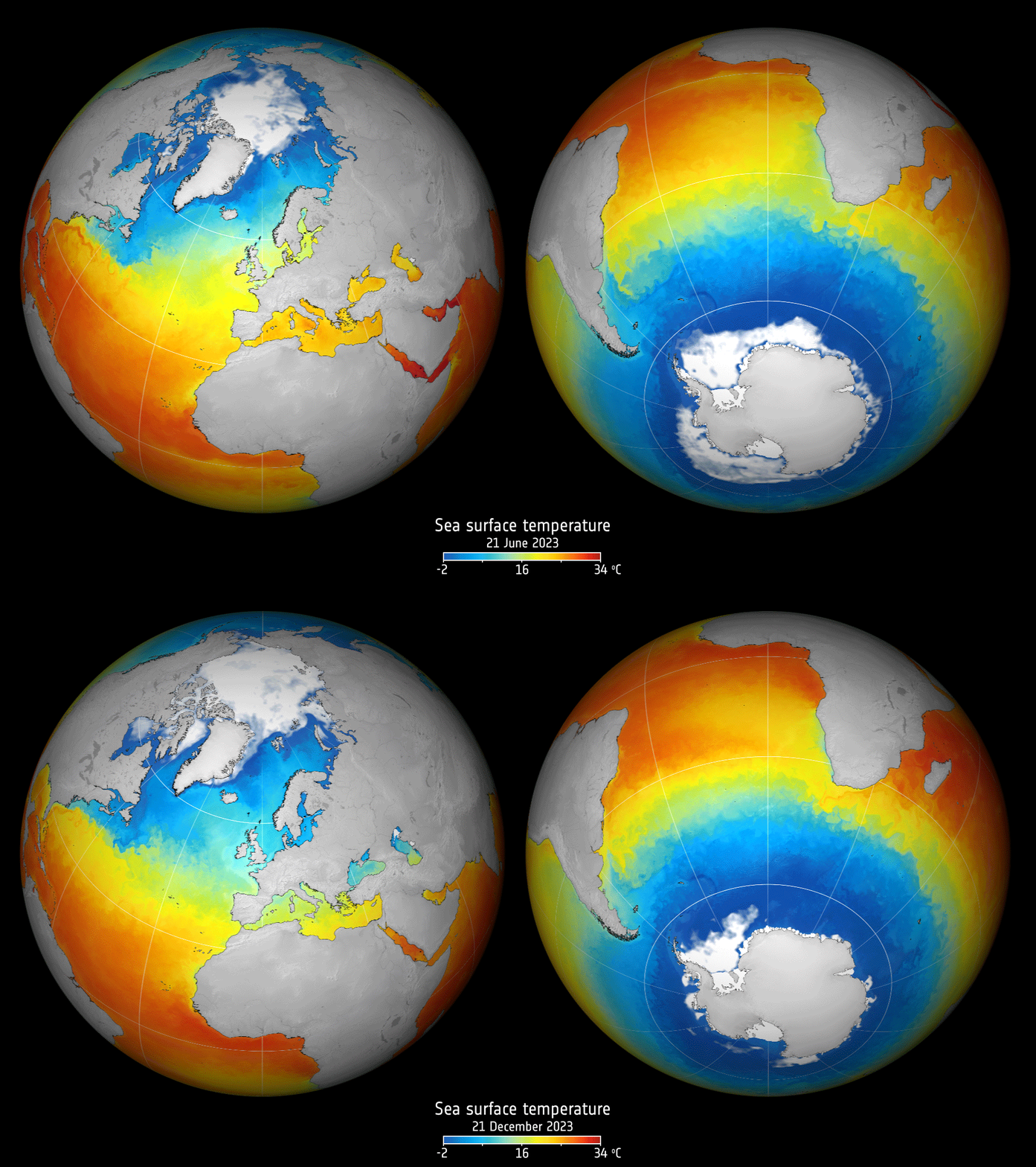
Satellite observations show that sea-surface temperatures over the past four decades have been getting warmer at an accelerated pace.
Missing nitrogen traced to deep Earth core in planetary formation simulations
 A longstanding mystery in Earth science may finally have an answer: why Earth's rocky mantle contains so little nitrogen compared to other volatile elements. According to a new study from Ehime University, most of Earth's nitrogen may have sunk into the core during its formation, effectively hiding it from view for billions of years.
During Earth's infancy, the planet was covered by a deep
 A 'fireball' lights up Mexico City skies, sparking awe and plenty of memes
This request seems a bit unusual, so we need to confirm that you're human. Please press and hold the button until it turns completely green. Thank you for your cooperation!
Press and hold the button
If you believe this is an error, please contact our support team.
185.132.36.159 : 786316bc-e50a-4d24-9fb1-6d7363f6
Webb spots clues of black hole at heart of nearby galaxy M83

Astronomers using the NASA/ESA/CSA James Webb Space Telescope have discovered evidence that suggests the presence of a long-sought supermassive black hole at the heart of the nearby spiral galaxy Messier 83 (M83). This surprising finding, made possible by Webb’s Mid-Infrared Instrument (MIRI), reveals highly ionised neon gas that could be a telltale signature of an active galactic nucleus (AGN), a growing black hole at the center of a galaxy.
Tree planting for Ignis
 Image:
Tree planting for Ignis

