
Copernical Team
Four station astronauts catch ride with SpaceX back home

Four astronauts in orbit since spring headed back to Earth on Monday, aiming for a late night splashdown off the Florida coast.
The undocking of their SpaceX capsule from the International Space Station also paved the way for a launch of their four replacements as early as Wednesday night.
The newcomers were scheduled to launch first, but NASA switched the order because of bad weather and an astronaut's undisclosed medical condition. The welcoming duties will now fall to the lone American and two Russians left behind at the space station.
NASA astronauts Shane Kimbrough and Megan McArthur, Japan's Akihiko Hoshide and France's Thomas Pesquet should have been back Monday morning, but high wind in the recovery zone delayed their homecoming.
Astronaut conducts first spacewalk by Chinese woman

High wind delays SpaceX crew homecoming after 6 months aloft

China's 1st woman to spacewalk works 6 hours outside station
High winds delay ISS astronauts' return to Earth
 A capsule carrying four astronauts home will leave the International Space Station on Monday rather than Sunday, NASA said, blaming high winds at the landing site for the delay.
The group including France's Thomas Pesquet, Japan's Akihiko Hoshide and US spacefarers Shane Kimbrough and Megan McArthur will undock at 1905 GMT on Monday.
"Due to high winds near the splashdown zone, the Crew-
A capsule carrying four astronauts home will leave the International Space Station on Monday rather than Sunday, NASA said, blaming high winds at the landing site for the delay.
The group including France's Thomas Pesquet, Japan's Akihiko Hoshide and US spacefarers Shane Kimbrough and Megan McArthur will undock at 1905 GMT on Monday.
"Due to high winds near the splashdown zone, the Crew- Astronaut becomes first Chinese woman to spacewalk
 Astronaut Wang Yaping became the first Chinese woman to walk in space, authorities said Monday, as her team completed a six-hour stint outside the Tiangong space station as part of its ongoing construction.
Tiangong - meaning "heavenly palace" - is the latest achievement in China's drive to become a major space power, after landing a rover on Mars and sending probes to the Moon.
Its co
Astronaut Wang Yaping became the first Chinese woman to walk in space, authorities said Monday, as her team completed a six-hour stint outside the Tiangong space station as part of its ongoing construction.
Tiangong - meaning "heavenly palace" - is the latest achievement in China's drive to become a major space power, after landing a rover on Mars and sending probes to the Moon.
Its co Thomas returns to Earth – watch live
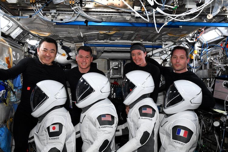
After almost 200 days in space it is time to return to planet Earth for ESA astronaut Thomas Pesquet, JAXA astronaut Aki Hoshide and NASA astronauts Shane Kimbrough and Megan McArthur.
Healable carbon fiber composite offers path to long-lasting, sustainable materials
 Because of their high strength and light weight, carbon-fiber-based composite materials are gradually replacing metals for advancing all kinds of products and applications, from airplanes to wind turbines to golf clubs. But there's a trade-off. Once damaged or compromised, the most commonly-used carbon fiber materials are nearly impossible to repair or recycle.
In a paper published Nov. 2
Because of their high strength and light weight, carbon-fiber-based composite materials are gradually replacing metals for advancing all kinds of products and applications, from airplanes to wind turbines to golf clubs. But there's a trade-off. Once damaged or compromised, the most commonly-used carbon fiber materials are nearly impossible to repair or recycle.
In a paper published Nov. 2 Electron family creates previously unknown state of matter
 Dissipationless electric energy transport-also known as superconductivity-is seen as a beacon of hope for the energy industry. Since its discovery more than 100 years ago, scientists around the world have been investigating this well-known quantum phenomenon, which, however, requires the electrons in metals to be cooled to ultra-low temperatures.
A team of scientists from the Cluster of Ex
Dissipationless electric energy transport-also known as superconductivity-is seen as a beacon of hope for the energy industry. Since its discovery more than 100 years ago, scientists around the world have been investigating this well-known quantum phenomenon, which, however, requires the electrons in metals to be cooled to ultra-low temperatures.
A team of scientists from the Cluster of Ex Ultra-precise magnetic field detection using squeezed light
 Precise detection of magnetic fields is important for applications that range from magnetic brain imaging, to detection of sunken ships, to exploration of the solar system. For many of these applications, the most sensitive magnetic-field measuring instruments (magnetometers) are "optically-pumped magnetometers," which use laser light to probe magnetically-sensitive atoms.
In many cases, t
Precise detection of magnetic fields is important for applications that range from magnetic brain imaging, to detection of sunken ships, to exploration of the solar system. For many of these applications, the most sensitive magnetic-field measuring instruments (magnetometers) are "optically-pumped magnetometers," which use laser light to probe magnetically-sensitive atoms.
In many cases, t 


