
Copernical Team
Enabling artificial intelligence on satellites
 Swarms of hundreds or thousands of small satellites are increasingly used for bringing data and internet services to Earth. To position, communicate and dispose such large amounts of satellites, Artificial Intelligence is getting increasingly important.
To enable a large-scale use of Artificial Intelligence in orbit, RUAG Space, Europe's leading supplier to the space industry, and Stream A
Swarms of hundreds or thousands of small satellites are increasingly used for bringing data and internet services to Earth. To position, communicate and dispose such large amounts of satellites, Artificial Intelligence is getting increasingly important.
To enable a large-scale use of Artificial Intelligence in orbit, RUAG Space, Europe's leading supplier to the space industry, and Stream A Summit to ignite Europe's bold space ambitions
 European leaders will reaffirm plans to launch Europe on a world-leading trajectory during a high-level space summit to be held on 16 February in Toulouse, France.
Urgent action is needed to tackle the unprecedented societal, economic and security challenges faced by Europe - from the climate crisis and its consequences to threats to crucial infrastructure in space and on Earth.
Spac
European leaders will reaffirm plans to launch Europe on a world-leading trajectory during a high-level space summit to be held on 16 February in Toulouse, France.
Urgent action is needed to tackle the unprecedented societal, economic and security challenges faced by Europe - from the climate crisis and its consequences to threats to crucial infrastructure in space and on Earth.
Spac Satellogic completes transaction to become publicly traded company
 Satellogic Inc., a leader in sub-meter resolution satellite imagery collection has completed its previously announced business combination with CF Acquisition Corp. V (Nasdaq: CFV) ("CFV"), a publicly traded special purpose acquisition company sponsored by Cantor Fitzgerald. The business combination was approved at a special meeting of CFV stockholders on January 24, 2022. Beginning Wednesday, J
 New tech spurs spaceplane vision: halfway around world in 40 minutes
 Seattle-area company Radian Aerospace plans to build and commercialize a true spaceplane that could take off from a commercial runway, fly to space and return under its own power - a feat never achieved in aerospace history.
The company emerged from secrecy in an announcement last week that said a former Boeing official who oversaw that company's X-33 spaceplane program, Livingston Hol
Seattle-area company Radian Aerospace plans to build and commercialize a true spaceplane that could take off from a commercial runway, fly to space and return under its own power - a feat never achieved in aerospace history.
The company emerged from secrecy in an announcement last week that said a former Boeing official who oversaw that company's X-33 spaceplane program, Livingston Hol Scientific hardware, experiments return to Earth on SpaceX CRS-24 Dragon
 conducts a session for the InSPACE-4 physics study, which could provideinsight into how to harness nanoparticles to fabricate and manufacture new materials for Earth and space applications. Credit: NASA")
A retired microscope and samples from studies on colloids and cellular signaling are among the cargo returning from the International Space Stationaboard the 24th SpaceX commercial resupply services mission. The Dragon craft, which arrived at the station Dec. 22, 2021, was scheduled to undock Jan. 22 with splashdown the next afternoon off the coast of Florida.
These quick return flights allow scientists to make additional observations and analyses of their experiments at Kennedy Space Center, minimizing the effects of gravity on samples.
Three, two, one: astronomers predict SpaceX space junk will hit the Moon

A chunk of a SpaceX rocket that blasted off seven years ago and was abandoned in space after completing its mission will crash into the Moon in March, experts say.
The rocket was employed in 2015 to put in orbit a NASA satellite called the Deep Space Climate Observatory.
Since then the second stage of the rocket, or booster, has been floating in what mathematicians call a chaotic orbit, astronomer Bill Gray told AFP Wednesday.
It was Gray who calculated the space junk's new collision course with the Moon.
The booster passed by pretty close to the Moon in January in a rendezvous that altered its orbit, said Gray.
He is behind Project Pluto, software that allows for calculating the trajectory of asteroids and other things in space and is used in NASA-financed space observation programs.
Beaming with science
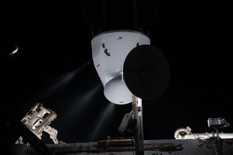 Image:
Astronauts aboard the International Space Station farewelled over 2000 kg of scientific experiments and hardware on Sunday 23 January as a cargo Dragon spacecraft began its return to Earth.
ESA astronaut Matthias Maurer captured the resupply vehicle in all its glory as it departed the orbital outpost at 15:40 GMT/16:40 CET. It splashed down approximately 29 hours later off the coast of Florida, USA.
The SpaceX spacecraft arrived at the Space Station just before Christmas, bringing new experiments alongside Christmas treats. It returned with a bellyful of science, including several European experiments that were quickly transported to NASA’s Space Station
Athens under snow
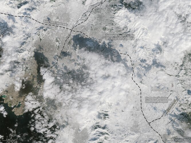 Image:
An unusual snowstorm has blanketed parts of Turkey and Greece, causing power cuts and chaos on the roads and flight cancellations. Two images from Copernicus Sentinel-2 show Athens before and after the snowstorm.
Image:
An unusual snowstorm has blanketed parts of Turkey and Greece, causing power cuts and chaos on the roads and flight cancellations. Two images from Copernicus Sentinel-2 show Athens before and after the snowstorm. Making a splash in a lava sea
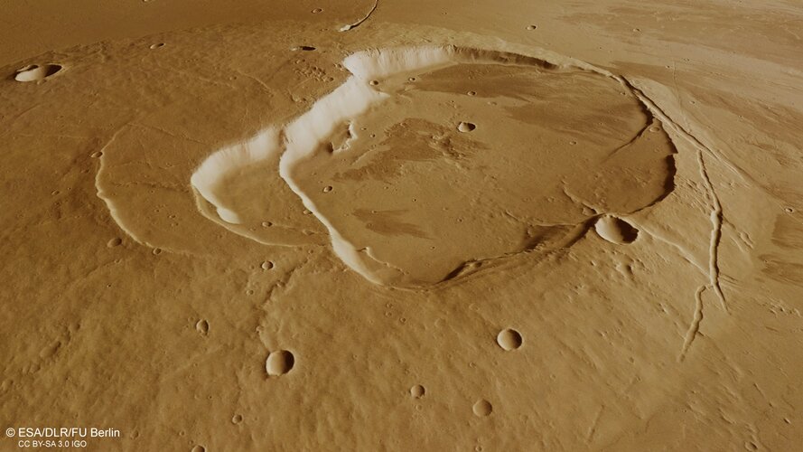
Volcanoes, impact craters, tectonic faults, river channels and a lava sea: a vast amount of information is captured in a relatively small area in this geologically rich new image from ESA’s Mars Express.
Forecasting performance of a space antenna – before it gets built
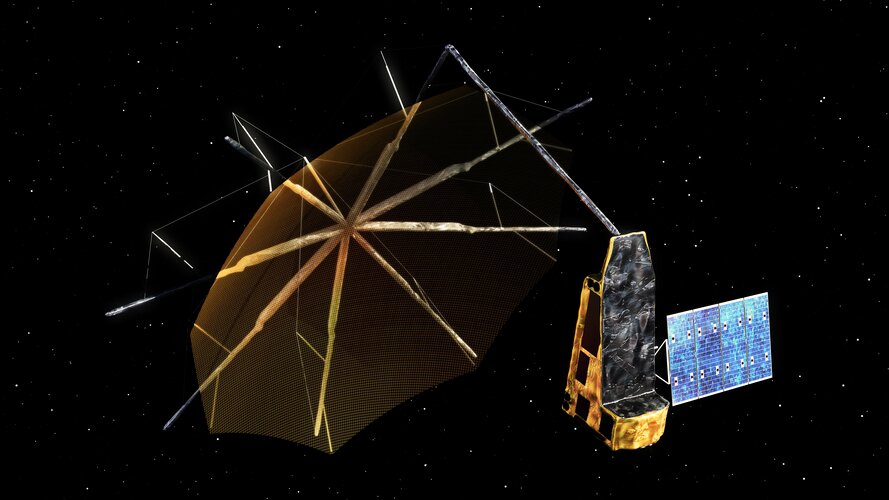
Antennas are among the most complex systems aboard a satellite – making them demanding to produce and often unpredictable to test. Tiny variables in their building, mounting or operation may impact their working performance in a big way. So ESA teamed up with Danish company TICRA to develop a method of forecasting such discrepancies well before an antenna construction even starts.