Displaying items by tag: cryosat2
CryoSat-2
CryoSat is an ESA programme which will monitor variations in the extent and thickness of polar ice through use of a satellite in low Earth orbit. The information provided about the behaviour of coastal glaciers that drain thinning ice sheets will be key to better predictions of future sea-level rise.
The CryoSat-1 spacecraft was lost in a launch failure in 2005, however the programme was resumed with the successful launch of a replacement, CryoSat-2, launched on 8 April 2010.
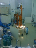
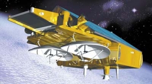
CryoSat-2 is a European Space Agency environmental research satellite which was launched in April 2010. It provides scientists with data about the polar ice caps and tracks changes in the thickness of the ice with a resolution of about 1⁄2 inches (1.3 cm). This information is useful for monitoring climate change. Cryosat 2 was built as a replacement for CryoSat-1, whose Rokot carrier rocket was unable to achieve orbit. ESA built a replacement, with software upgrades and greater battery capacity, which carries an interferometric radar range-finder with twin antennas which measures the height difference between floating ice and open water. CryoSat-2 is operated as part of the CryoSat programme to study the Earth's polar ice caps, which is itself part of the Living Planet programme. The CryoSat-2 spacecraft was constructed by EADS Astrium, and was launched by ISC Kosmotras, using a Dnepr-1 carrier rocket, on 8 April 2010. On 22 October 2010, CryoSat-2 was declared operational following six months of on-orbit testing.
CryoSat-2 is operated from the European Space Operations Centre (ESOC) in Darmstadt, Germany.
CryoSat-1
CryoSat-1, also known as just CryoSat, was a European Space Agency satellite which was lost in a launch failure in 2005. It was to have been operated as part of the CryoSat programme to study the Earth's polar ice caps.
The CryoSat spacecraft was intended to operate in low Earth orbit for three years. It had a mass of 750 kilograms (1,700 lb) Its primary instrument, SIRAL, was to have used radar to determine and monitor the spacecraft's altitude in order to measure the elevation of the ice, and for radar imaging of the ice caps. A second instrument, DORIS, was to have been used to calculate precisely the spacecraft's orbit. It also carried an array of retroreflectors which would have allowed measurements to be made from the ground to verify the orbital data provided by DORIS.
CryoSat was launched from Site 133/3 at the Plesetsk Cosmodrome at 15:02:00 UTC on 8 October 2005. The launch was conducted by Eurockot, using a Rokot carrier rocket with a Briz-KM upper stage. The command to shut down the rocket's second stage engine was missing from the flight control system, and consequently the stage burned to depletion. This prevented the second stage from separating from the Briz-KM, and as a result the rocket was unable to achieve orbit. It reentered over the Arctic Ocean, north of Greenland. A replacement satellite, CryoSat-2, was successfully launched in 2010.