Displaying items by tag: weather satellite
MetOp (Meteorological Operational Satellite Program of Europe)
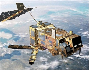
MetOp-A is Europe's first polar-orbiting (LEO) satellite dedicated to operational meteorology. The MetOp program was originally planned as a much larger satellite concept, called POEM (Polar-Orbit Earth-Observation Mission), a successor mission series to ERS-1/2 on the Columbus Polar Platform (PPF design).
However, this idea was abandoned at the ESA Ministerial Council in Granada, Spain, in 1992. Instead, Envisat and MetOp were born. Full approval of the EPS (EUMETSAT Polar System) program was granted in September 1998. The MetOp program is planned as a series of three satellites to be launched sequentially over an observational period of 14 years, starting in 2006 with MetOp-A (2010, 2014), it represents the space segment of EPS. 1) 2)
Multifunctional Transport Satellites (MTSAT)
Multifunctional Transport Satellites (MTSAT) are a series of weather and aviation control satellites.
They are geostationary satellites owned and operated by the Japanese Ministry of Land, Infrastructure and Transport and the Japan Meteorological Agency (JMA), and provide coverage for the hemisphere centred on 140° East; this includes Japan and Australia who are the principal users of the satellite imagery that MTSAT provides.
They replace the GMS-5 satellite, also known as Himawari 5. They can provide imagery in five wavelength bands — visible and four infrared, including the water vapour channel. The visible light camera has a resolution of 1 km; the infrared cameras have 4 km (resolution is lower away from the equator at 140° East). The spacecraft have a planned lifespan of five years. MTSAT-1 and 1R were built by Space Systems/Loral. MTSAT-2 was built by Mitsubishi.
- MTSAT-1R (140 ° E), also known as Himawari 6, was launched February 2005 and is now (Oct. 2013) in standby. It performed 5 years operations.
- MTSAT-2, also known as Himawari 7, successfully launched 18th February 2006, is operational since 2010 (text dated Oct. 2013).
The ground stations for both satellites are located in Kobe and Hitachiota, Japan.
EPS (EUMETSAT Polar System)
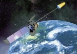
The EUMETSAT Polar System (EPS) is a European satellite system that offers remote sensing capabilities to both meteorologists and climatologists. It consists of a series of three polar orbiting Metop satellites, to be flown successively for more than 14 years, from 2006, together with the relevant ground facilities.
The satellites form the space segment component of the overall EPS system, which in turn is the European half of the EUMETSAT/NOAA Initial Joint Polar System (IJPS).
Metop-A (launched on 19 October 2006) and Metop-B (launched on 17 September 2012) are in a lower polar orbit, at an altitude of 817 kilometres, to provide more detailed observations of the global atmosphere, oceans and continents. The two satellites will operate in parallel for as long as Metop-A's available capacities bring benefits to users. Metop-C is due to be launched in 2017.
EPS Programme Background
EUMETSAT is responsible for coordinating all elements of the development, launch and operation of EPS satellites. This includes developing and procuring the ground segment; procuring the launcher and launch site, and operating the systems. Under the IJPS and Joint Transition Activities (JTA) agreement, EUMETSAT and NOAA have agreed to provide instruments for each other's satellites; exchange all data in real time, and assist each other with backup services. Other partners are European Space Agency and CNES.
The European and American satellites carry a set of identical sensors:
AVHRR/3 and the ATOVS suite consisting of AMSU-A, HIRS/4 and MHS. NOAA provides most of the joint instruments on board the satellites and EUMETSAT has developed and provides NOAA with the Microwave Humidity Sounder (MHS).
In addition, the Metop satellites carry a set of European sensors, IASI, ASCAT, GOME-2 and GRAS, aimed at improving atmospheric soundings, as well as measuring atmospheric ozone and near-surface wind vectors over the ocean. They also carry the Argos Advanced Data Collection System (A-DCS).
Aeolus satellite
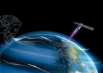
ADM-Aeolus, or, in full, Atmospheric Dynamics Mission Aeolus, is an ESA satellite that is due for launch in 2014.
ADM-Aeolus will be the first equipment capable of performing global wind-component-profile observation and will provide much-needed information to improve weather forecasting.