Displaying items by tag: satellite constellation
THEMIS (ARTEMIS)
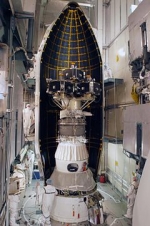
The Time History of Events and Macroscale Interactions during Substorms (THEMIS) mission was originally a constellation of five NASA satellites to study energy releases from Earth's magnetosphere known as substorms, magnetic phenomena that intensify auroras near Earth's poles. The name of the mission is an acronym alluding to the Titan, Themis.
Now three of the original satellites remain in the magnetosphere, while two have been moved into orbit near the Moon. Those two have been renamed ARTEMIS for Acceleration, Reconnection, Turbulence and Electrodynamics of the Moon’s Interaction with the Sun, but are also called ARTEMIS P1 (THEMIS B) and ARTEMIS P2 (THEMIS C).
The THEMIS satellites were launched February 17, 2007 from Cape Canaveral Air Force Station Space Launch Complex 17 aboard a Delta II rocket. Each satellite carries identical instrumentation, including a fluxgate magnetometer (FGM), an electrostatic analyzer (ESA), a solid state telescope (SST), a search-coil magnetometer (SCM) and an electric field instrument (EFI). Each has a mass of 126 kg, including 49 kg of fuel.
Launch date 2007-02-17 23:01:00 UTC
Galileo Navigation Program
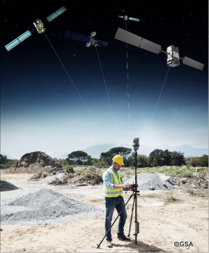
Galileo is a joint initiative of the European Commission (EC) and the European Space Agency (ESA). Galileo will be Europe’s own global navigation satellite system, providing a highly accurate, guaranteed global positioning service under civilian control. It will be inter-operable with GPS and GLONASS, the two other GNSS (Global Navigation Satellite Systems). The complete system consists of:
• A space segment of 30 MEO satellites in 3 planes inclined at 56º
• A launch segment to place the satellites into their operational orbits
• A control ground segment for monitoring and control of the satellites
• A mission ground segment managing all mission specific data
• A user ground segment of equipment capable of receiving and using Galileo signals
Global Positioning System (GPS)
The Global Positioning System (GPS) is a space-based satellite navigation system that provideslocation and time information in all weather, anywhere on or near the Earth, where there is an unobstructed line of sight to four or more GPS satellites. It is maintained by the United Statesgovernment and is freely accessible by anyone with a GPS receiver with some technical limitations which are only removed for military users.
The GPS program provides critical capabilities to military, civil and commercial users around the world. It is an engine of economic growth and jobs, and has generated billions of dollars of economic activity. It maintains future warfighter advantage over opponents and is one of the four core military capabilities. In addition, GPS is the backbone for modernizing the global air traffic system.
The GPS project was developed in 1973 to overcome the limitations of previous navigation systems, integrating ideas from several predecessors, including a number of classified engineering design studies from the 1960s. GPS was created and realized by the U.S. Department of Defense (DoD) and was originally run with 24 satellites. It became fully operational in 1994.
Advances in technology and new demands on the existing system have now led to efforts to modernize the GPS system and implement the next generation of GPS III satellites and Next Generation Operational Control System (OCX). Announcements from the Vice President and the White House in 1998 initiated these changes. In 2000, U.S. Congress authorized the modernization effort, referred to as GPS III.
In addition to GPS, other systems are in use or under development. The Russian GLObal NAvigation Satellite System (GLONASS) was in use by only the Russian military, until it was made fully available to civilians in 2007. There are also the planned European Union Galileo positioning system, Chinese Compass navigation system, and Indian Regional Navigational Satellite System.
GLONASS
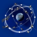
GLONASS is a radio-based satellite navigation system operated for the Russian government by the Russian Space Forces. It both complements and provides an alternative to the United States' Global Positioning System (GPS), the Chinese Compass navigation system and the planned Galileo positioning system of the European Union.
Development of GLONASS began in the Soviet Union in 1976. Beginning on 12 October 1982, numerous rocket launches added satellites to the system until the "constellation" was completed in 1995. In the first decade of the 21st century, under Vladimir Putin's presidency, the restoration of the system was made a top government priority and funding was substantially increased. GLONASS is currently the most expensive program of the Russian Federal Space Agency, consuming a third of its budget in 2010.
By 2010, GLONASS had achieved 100% coverage of Russia's territory and in October 2011, the full orbital constellation of 24 satellites was restored, enabling full global coverage. The GLONASS satellites designs have undergone several upgrades, with the latest version being GLONASS-K.