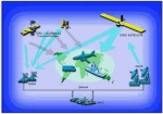
Displaying items by tag: GNSS
European GNSS Agency (GSA)

As an official European Union regulatory authority, the European GNSS Agency (GSA) manages public interests related to European GNSS(*) programmes.
The Agency's strategic objectives include the achievement of a fully operational GALILEO system. This includes the laying of foundations for a fully sustainable and economically viable system and its security.
(*) GNSS: Global Navigation Satellite Systems
EGNOS
The European Geostationary Navigation Overlay Service (EGNOS) is a satellite based augmentation system developed by the European Space Agency (ESA), the European Commission and EUROCONTROL.
The EGNOS system provides additional signals to users of satellite navigation services, broadcast through geostationary satellites, guaranteeing the integrity of satellite navigation so that it can be used in support of safety-of-life services such as civil aviation.
It supplements the GPS, GLONASS and Galileo systems by reporting on the reliability and accuracy of the positioning data. The official start of operations was announced by the European Commission on 1 October 2009.
According to specifications, horizontal position accuracy should be better than seven metres. In practice, the horizontal position accuracy is at the metre level. The EGNOS system consists of three geostationary satellites and a network of ground stations.
The system started its initial operations in July 2005, showing outstanding performances in terms of accuracy (better than two metres) and availability (above 99%); and it was certified for use in safety of life applications in March 2011. An EGNOS Data Access Service is also available since July 2012.
Similar service is provided in North America by the Wide Area Augmentation System (WAAS), and in Asia, notably Japan, by the Multi-functional Satellite Augmentation System (MSAS).
Beidou navigation system

The BeiDou Navigation System is a project of China to develop an independent satellite navigation system. It may refer to either one or both generations of the Chinese navigation system.
The first BeiDou system, officially called BeiDou Satellite Navigation Experimental System, or known as BeiDou-1, consists of three satellites and offers limited coverage and applications. It has been offering navigation services, mainly for customers in China and neighboring regions, since 2000.
The second generation of the system, known as Compass or BeiDou-2, which will be a global satellite navigation system consisting of 35 satellites, is still under construction as of May 2012. It became operational in China in December 2011, with 10 satellites in use. It is planned to offer services to customers in the Asia-Pacific region by 2012, and to global customers upon its completion in 2020.
The BeiDou Navigation System is sometimes named BDS.
Galileo Navigation Program
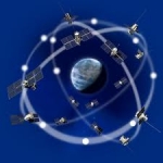
Galileo is a joint initiative of the European Commission (EC) and the European Space Agency (ESA). Galileo will be Europe’s own global navigation satellite system, providing a highly accurate, guaranteed global positioning service under civilian control. It will be inter-operable with GPS and GLONASS, the two other GNSS (Global Navigation Satellite Systems). The complete system consists of:
• A space segment of 30 MEO satellites in 3 planes inclined at 56º
• A launch segment to place the satellites into their operational orbits
• A control ground segment for monitoring and control of the satellites
• A mission ground segment managing all mission specific data
• A user ground segment of equipment capable of receiving and using Galileo signals
Global Positioning System (GPS)
The Global Positioning System (GPS) is a space-based satellite navigation system that provideslocation and time information in all weather, anywhere on or near the Earth, where there is an unobstructed line of sight to four or more GPS satellites. It is maintained by the United Statesgovernment and is freely accessible by anyone with a GPS receiver with some technical limitations which are only removed for military users.
The GPS program provides critical capabilities to military, civil and commercial users around the world. It is an engine of economic growth and jobs, and has generated billions of dollars of economic activity. It maintains future warfighter advantage over opponents and is one of the four core military capabilities. In addition, GPS is the backbone for modernizing the global air traffic system.
The GPS project was developed in 1973 to overcome the limitations of previous navigation systems, integrating ideas from several predecessors, including a number of classified engineering design studies from the 1960s. GPS was created and realized by the U.S. Department of Defense (DoD) and was originally run with 24 satellites. It became fully operational in 1994.
Advances in technology and new demands on the existing system have now led to efforts to modernize the GPS system and implement the next generation of GPS III satellites and Next Generation Operational Control System (OCX). Announcements from the Vice President and the White House in 1998 initiated these changes. In 2000, U.S. Congress authorized the modernization effort, referred to as GPS III.
In addition to GPS, other systems are in use or under development. The Russian GLObal NAvigation Satellite System (GLONASS) was in use by only the Russian military, until it was made fully available to civilians in 2007. There are also the planned European Union Galileo positioning system, Chinese Compass navigation system, and Indian Regional Navigational Satellite System.
GLONASS
GLONASS is a radio-based satellite navigation system operated for the Russian government by the Russian Space Forces. It both complements and provides an alternative to the United States' Global Positioning System (GPS), the Chinese Compass navigation system and the planned Galileo positioning system of the European Union.
Development of GLONASS began in the Soviet Union in 1976. Beginning on 12 October 1982, numerous rocket launches added satellites to the system until the "constellation" was completed in 1995. In the first decade of the 21st century, under Vladimir Putin's presidency, the restoration of the system was made a top government priority and funding was substantially increased. GLONASS is currently the most expensive program of the Russian Federal Space Agency, consuming a third of its budget in 2010.
By 2010, GLONASS had achieved 100% coverage of Russia's territory and in October 2011, the full orbital constellation of 24 satellites was restored, enabling full global coverage. The GLONASS satellites designs have undergone several upgrades, with the latest version being GLONASS-K.