Displaying items by tag: Earth observation
Satellite Imaging Corporation

Satellite Imaging Corporation (SIC) is the official Value Added Reseller (VAR) of imaging and geospatial data products for:
IKONOS
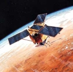
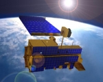
IKONOS is a commercial earth observation satellite, and was the first to collect publicly available high-resolution imagery at 1-meter and 4-meter resolution. It offers multispectral (MS) and panchromatic (PAN) imagery.
IKONOS imagery began being sold on January 1, 2000.
It derived its name from the Greek term eikōn for image.
It is operated by GeoEye.
GeoEye Inc.

GeoEye Inc. (formerly Orbital Imaging Corporation or ORBIMAGE) is a commercial satellite imagery company based in Herndon, Virginia, USA.
GeoEye operates its own fleet of Earth observation satellites, which provide visible and near-infrared images of land and sea at resolutions below 1 m.
GeoEye provides 253,000,000 square kilometres of satellite map images to Microsoft and Yahoo! search engines. Google has exclusive online mapping use of the new GeoEye-1 satellite. It is a major supplier to the USA National Geospatial-Intelligence Agency.
GeoEye's headquarters are in Herndon, Virginia. Satellite Operations are conducted in Herndon, Virginia and in Thornton, Colorado. The location in Saint Louis, Missouri provides additional image processing. There are multiple ground stations located worldwide.
GeoEye's primary competitors are DigitalGlobe and Spot Image.
The company was founded in 1992 as a division of Orbital Sciences Corporation in the wake of the 1992 Land Remote Sensing Policy Act which permitted private companies to enter the satellite imaging business. The division was spun off in 1997. It changed its name to GeoEye in 2006 after acquiring Denver, Colorado-based Space Imaging. Space Imaging was founded and controlled by Raytheon and Lockheed Martin. Its principal asset was the IKONOS satellite.
IRS-P3
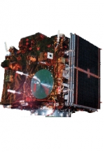
IRS-P3 is an Indian experimental Earth Observation mission, considered to be pre-operational and serving in parallel for technology evaluation and scientific methodology studies.
It was launched by PSLV-D3 on March 21, 1996 from SHAR Centre, Sriharikota, India. IRS-P3 carries two remote sensing payloads - Wide Field Sensor (WiFS) similar to that of IRS-1C, with an additional Short Wave Infrared Band (SWIR) and a Modular Opto-electronic Scanner (MOS). It also carries an X-ray astronomy payload and a C-band transponder for radar calibration.
Mission completed during January 2006 after serving 9 years and 10 months.
ScanEx R&D Center

ScanEx Research and Development Center (ScanEx R&D Center) is a Russian company on the remote sensing market.
It offers a set of services ranging from acquisition to thematic processing of Earth observation images from space. In 2012, ScanEx had signed license agreements with the top world remote sensing operators for direct data acquisition from IRS, SPOT, EROS, RADARSAT and ENVISAT satellites series to proprietary UniScan™ ground stations, enabling regular near real-time monitoring of territories of Russia and the CIS countries with spatial resolution from hundreds to less than one meter.
MSG - Meteosat Second Generation
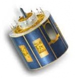
MSG, Meteosat Second Generation, is a serie of geostationary meteorological satellites operated by EUMETSAT.
It consists of a series of four geostationary meteorological satellites, along with ground-based infrastructure, that will operate consecutively until 2020. The MSG satellites carry a pair of instruments — the Spinning Enhanced Visible and InfraRed Imager (SEVIRI), which has the capacity to observe the Earth in 12 spectral channels and provide image data which is core to operational forecasting needs, and the Geostationary Earth Radiation Budget (GERB) instrument supporting climate studies.
It was designed in response to user requirements to serve the needs of Nowcasting applications and numerical weather prediction. In addition the GERB instrument provides important data for climate monitoring and research.
The MSG satellites are spin-stabilised like the previous generation, but with many design improvements. The more frequent and comprehensive data collected by MSG also aids the weather forecaster in the swift recognition and prediction of dangerous weather phenomena such as thunderstorms, fog and explosive development of small but intense depressions which can lead to devastating wind storms.
The MSG satellites are 3.2 m in diameter and 2.4 m high and spins anti-clockwise at 100 RPM at an altitude of 36,000 km.
On January 29, 2004 the first Meteosat Second Generation satellite MSG-1, renamed to Meteosat-8, commenced routine operations.
SAOCOM
SAOCOM (SAtélite Argentino de Observación COn Microondas, Spanish for Argentine Microwaves Observation Satellite) is a planned Earth observation satellite series of the Argentine Space Agency CONAE. Two satellites are planned, SAOCOM 1A and SAOCOM 1B. Both will be equipped with a L-band full polarimetric Synthetic Aperture Radar (SAR). Originally launch was announced for 2010 (1A) and 2011 (1B), but later due to delays in satellites' development both launches were postponed to between 2012 and 2013. Further delays pushed the launches date back tentatively towards 2014 and 2015 respectively for 1A and 1B satellites. Those two satellites along with four X-band SAR equipped COSMO-SkyMed satellites from the Italian Space Agency ASI would conform the Italian-Argentine System of Satellites for Emergency Management (SIASGE) constellation.
SAC-D
SAC-D (Spanish: Satelite de Aplicaciones Cientificas-D, meaning Satellite for Scientific Applications-D), also known as Aquarius after its primary instrument, is an Argentine Earth science satellite built by INVAP and launched on June 10, 2011. It carries seven instruments to study the environment, and a technology demonstration experiment.
Its primary instrument, Aquarius, was built by and is operated by the United States National Aeronautics and Space Administration.
SAC-D is operated by CONAE, the Argentine space agency. The satellite is expected to operate for five years; however the Aquarius instrument is only expected to operate for three.
ESA - ESRIN (European Space Agency)

The ESA Centre for Earth Observation (also known as ESRIN) located in Frascati, Italy, is one of the five specialised centres of the European Space Agency (ESA) located across Europe.
Located in Frascati, a small town 20 km south of Rome in Italy, ESRIN was established in 1966 and first began acquiring data from environmental satellites in the 1970s.
Earth observation: Earth Observation data has grown in importance as more and more international and national agencies recognise the many uses to which it can be put. Satellites for Earth observation keep a constant watch over the Earth and the data they provide help to safeguard the planet in which we live. Since 2004, ESRIN has been the headquarters for ESA's Earth Observation activities.
A multi-faceted centre: A number of other activities are also carried out at ESRIN, each of which is making an important contribution to ESA’s work. Among other things the establishment hosts the ESA development team for the Vega Launcher.
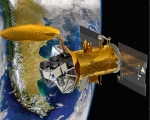
Terra
Terra (EOS AM-1) is a multi-national NASA scientific research satellite in a sun-synchronous orbit around the Earth.[1] It is the flagship of the Earth Observing System (EOS). The name "Terra" comes from the Latin word for Earth.
Launch
The satellite was launched from Vandenberg Air Force Base on December 18, 1999, aboard an Atlas IIAS vehicle and began collecting data on February 24, 2000.
Mission
Terra carries a payload of five remote sensors designed to monitor the state of Earth's environment and ongoing changes in its climate system:
- ASTER (Advanced Spaceborne Thermal Emission and Reflection Radiometer)
- CERES (Clouds and the Earth's Radiant Energy System)
- MISR (Multi-angle Imaging SpectroRadiometer)
- MODIS (Moderate-resolution Imaging Spectroradiometer)
- MOPITT (Measurements of Pollution in the Troposphere)
Data from the satellite helps scientists better understand the spread of pollution around the globe. Studies have used instruments on Terra to examine trends in global carbon monoxide and aerosol pollution. The data collected by Terra will ultimately become a new, 15-year global data set.