Displaying items by tag: satellite
SMOS
SMOS — the second Earth Explorer mission launched on November 2009 designed to measure Soil Moisture and Ocean Salinity.
The Soil Moisture and Ocean Salinity Satellite (SMOS) is a part of ESA's Living Planet Programme intended to provide new insights into Earth's water cycle and climate. In addition, it will provide better weather forecasting and will also monitor snow and ice accumulation.
INTEGRAL
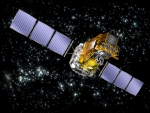
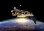
INTEGRAL is the first space observatory that can simultaneously observe objects in gamma rays, X-rays and visible light.
The European Space Agency's INTErnational Gamma-Ray Astrophysics Laboratory (INTEGRAL) is an operational Earth satellite, launched in 2002 for detecting some of the most energetic radiation that comes from space. It is the most sensitive gamma ray observatory ever launched.
INTEGRAL is an ESA mission in cooperation with the Russian Space Agency and NASA. It has had some notable successes, for example in detecting a mysterious 'iron quasar'. It has also had great success in investigating gamma-ray bursters and evidence for black holes.
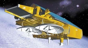
GOCE
A mission designed to measure the Earth's gravity field, launched on march 2009.
The Gravity Field and Steady-State Ocean Circulation Explorer (GOCE) is an ESA satellite that was launched on March 17, 2009. It is a satellite carrying a highly sensitive gravity gradiometer which detects fine density differences in the crust and oceans of the Earth.
GOCE data will have many uses, probing hazardous volcanic regions and bringing new insight into ocean behaviour. The latter, in particular, is a major driver for the mission. By combining the gravity data with information about sea surface height gathered by other satellite altimeters, scientists will be able to track the direction and speed of geostrophic ocean currents. The low orbit and high accuracy of the system will greatly improve the known accuracy and spatial resolution of the geoid (the theoretical surface of equal gravitational potential on the Earth).
The satellite's arrow shape and fins help keep the GOCE stable as it flies through the wisps of air still present at an altitude of 260 km. In addition, an ion propulsion system continuously compensates for the deceleration of air-drag without the vibration of a conventional chemically-powered rocket engine, thus restoring the path of the craft as closely as possible to a purely inertial trajectory. The craft's primary instrument is three pairs of highly sensitive accelerometers which measure gravitational gradients along three different axes.
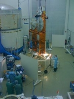
GIOVE-A2
GIOVE, or Galileo In-Orbit Validation Element, is the name for each satellite in a series being built for the European Space Agency (ESA) to test technology in orbit for the Galileo positioning system.
Giove is the Italian word for "Jupiter". The name was chosen as a tribute to Galileo Galilei, who discovered the first four natural satellites of Jupiter, and later discovered that they could be used as a universal clock to obtain the longitude of a point on the Earth's surface.
The GIOVE satellites are exploited by the GIOVE Mission (GIOVE-M) segment in the frame of the risk mitigation for the In Orbit Validation (IOV) of the Galileo positioning system.
GIOVE-A2
With the delays of GIOVE-B, the European Space Agency again contracted with SSTL for a second satellite, to ensure that the Galileo programme continues without any interruptions that could lead to loss of frequency allocations. Construction of GIOVE-A2 was terminated due to the successful launch and in-orbit operation of GIOVE-B.
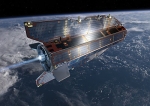
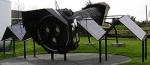
CryoSat-2
CryoSat is an ESA programme which will monitor variations in the extent and thickness of polar ice through use of a satellite in low Earth orbit. The information provided about the behaviour of coastal glaciers that drain thinning ice sheets will be key to better predictions of future sea-level rise.
The CryoSat-1 spacecraft was lost in a launch failure in 2005, however the programme was resumed with the successful launch of a replacement, CryoSat-2, launched on 8 April 2010.
CryoSat-2 is a European Space Agency environmental research satellite which was launched in April 2010. It provides scientists with data about the polar ice caps and tracks changes in the thickness of the ice with a resolution of about 1⁄2 inches (1.3 cm). This information is useful for monitoring climate change. Cryosat 2 was built as a replacement for CryoSat-1, whose Rokot carrier rocket was unable to achieve orbit. ESA built a replacement, with software upgrades and greater battery capacity, which carries an interferometric radar range-finder with twin antennas which measures the height difference between floating ice and open water. CryoSat-2 is operated as part of the CryoSat programme to study the Earth's polar ice caps, which is itself part of the Living Planet programme. The CryoSat-2 spacecraft was constructed by EADS Astrium, and was launched by ISC Kosmotras, using a Dnepr-1 carrier rocket, on 8 April 2010. On 22 October 2010, CryoSat-2 was declared operational following six months of on-orbit testing.
CryoSat-2 is operated from the European Space Operations Centre (ESOC) in Darmstadt, Germany.
CryoSat-1
CryoSat-1, also known as just CryoSat, was a European Space Agency satellite which was lost in a launch failure in 2005. It was to have been operated as part of the CryoSat programme to study the Earth's polar ice caps.
The CryoSat spacecraft was intended to operate in low Earth orbit for three years. It had a mass of 750 kilograms (1,700 lb) Its primary instrument, SIRAL, was to have used radar to determine and monitor the spacecraft's altitude in order to measure the elevation of the ice, and for radar imaging of the ice caps. A second instrument, DORIS, was to have been used to calculate precisely the spacecraft's orbit. It also carried an array of retroreflectors which would have allowed measurements to be made from the ground to verify the orbital data provided by DORIS.
CryoSat was launched from Site 133/3 at the Plesetsk Cosmodrome at 15:02:00 UTC on 8 October 2005. The launch was conducted by Eurockot, using a Rokot carrier rocket with a Briz-KM upper stage. The command to shut down the rocket's second stage engine was missing from the flight control system, and consequently the stage burned to depletion. This prevented the second stage from separating from the Briz-KM, and as a result the rocket was unable to achieve orbit. It reentered over the Arctic Ocean, north of Greenland. A replacement satellite, CryoSat-2, was successfully launched in 2010.
Envisat
Envisat ("Environmental Satellite") is an Earth observation satellite. Its objective is to service the continuity of European Remote-Sensing Satellite missions, providing additional observational parameters to improve environmental studies.
In working towards the global and regional objectives of the mission, numerous scientific disciplines use the data acquired from the different sensors on the satellite, to study such things as atmospheric chemistry, ozone depletion, biological oceanography, ocean temperature and colour, wind waves, hydrology (humidity, floods), agriculture and arboriculture, natural hazards, digital elevation modelling (using interferometry), monitoring of maritime traffic, atmospheric dispersion modelling (pollution), cartographyand study of snow and ice.
It was launched on 1 March 2002 aboard an Ariane 5 from the Guyana Space Centre in Kourou, French Guyana into a Sun synchronous polar orbit at an altitude of 790 km (490 mi) (± 10 km (6.2 mi)). It orbits the Earth in about 101 minutes with a repeat cycle of 35 days.
Envisat is the largest earth observation satellite put into space (as of late 2006), being 26 m (85 ft) × 10 m (33 ft) × 5 m (16 ft) and having a mass of 8.5 t (8.4 long tons; 9.4 short tons).
The Envisat mission ended on 08 April 2012, following the unexpected loss of contact with the satellite.
Envisat data collectively provide a wealth of information on the workings of the Earth system, including insights into factors contributing to climate change.
THEMIS (ARTEMIS)
The Time History of Events and Macroscale Interactions during Substorms (THEMIS) mission was originally a constellation of five NASA satellites to study energy releases from Earth's magnetosphere known as substorms, magnetic phenomena that intensify auroras near Earth's poles. The name of the mission is an acronym alluding to the Titan, Themis.
Now three of the original satellites remain in the magnetosphere, while two have been moved into orbit near the Moon. Those two have been renamed ARTEMIS for Acceleration, Reconnection, Turbulence and Electrodynamics of the Moon’s Interaction with the Sun, but are also called ARTEMIS P1 (THEMIS B) and ARTEMIS P2 (THEMIS C).
The THEMIS satellites were launched February 17, 2007 from Cape Canaveral Air Force Station Space Launch Complex 17 aboard a Delta II rocket. Each satellite carries identical instrumentation, including a fluxgate magnetometer (FGM), an electrostatic analyzer (ESA), a solid state telescope (SST), a search-coil magnetometer (SCM) and an electric field instrument (EFI). Each has a mass of 126 kg, including 49 kg of fuel.
Launch date 2007-02-17 23:01:00 UTC
International Space Station (ISS)
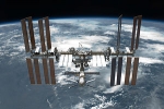
The International Space Station (ISS) is a habitable artificial satellite in low Earth orbit. It follows the Salyut, Almaz, Skylab and Mir stations as the ninth space station to be inhabited. The ISS is a modular structure whose first component was launched in 1998. Like many artificial satellites, the station can be seen from Earth with the naked eye. The ISS consists of pressurised modules, external trusses, solar arrays and other elements. ISS components have been launched by American Space Shuttles as well as Russian Proton and Soyuz rockets. Budget constraints led to the merger of three space station projects with the Japanese Kibō module and Canadian robotics. In 1993 the Soviet/Russian Mir-2, the American Freedom, and the European Columbus, merged into a single multi-national programme. The Russian Federal Space Agency plans to separate some of its modules from the Russian segment to form theOPSEK facility before the remainder of the station is deorbited.
The ISS serves as a microgravity and space environment research laboratory in which crew members conduct experiments in biology, human biology, physics, astronomy, meteorology and other fields. The station is suited for the testing of spacecraft systems and equipment required for missions to the Moon and Mars.
The station has been continuously occupied for 11 years and 121 days having exceeded the previous record of almost 10 years (or 3,644 days) held by Mir, in 2010. The station is serviced by Soyuz spacecraft,Progress spacecraft, the Automated Transfer Vehicle, the H-II Transfer Vehicle, and formerly the Space Shuttle. It has been visited by astronauts and cosmonauts from 15 different nations.
The ISS programme is a joint project between five participating space agencies, the American NASA, the Russian RKA, the Japanese JAXA, the European ESA, and the Canadian CSA. The ownership and use of the space station is established by intergovernmental treaties and agreements. The station is divided into two sections, the Russian orbital segment (ROS) and the United States orbital segment(USOS), which is shared by many nations. The ISS is maintained at an orbital altitude of between 330 km (205 mi) and 410 km (255 mi). It completes 15.7 orbits per day. The ISS is expected to remain in operation until at least 2020, and potentially to 2028.
XMM-Newton
The XMM-Newton (X-ray Multi-Mirror Mission - Newton) is an orbiting X-ray observatory launched by ESA in December 1999 on a Ariane 5 rocket. It is named in honor of Sir Isaac Newton.
Its mission is turned towards deep space and aimes to increasing our knowledge of very hot objects created when the Universe was very young,
Originally known as the High Throughput X-ray Spectroscopy Mission it was placed in a very eccentric 48 hour elliptical orbit at 40°; at its apogee it is nearly 114,000 kilometres (71,000 mi) from Earth, while theperigee is only 7,000 kilometres (4,300 mi)
The satellite weighs 3,800 kilograms (8,400 lb), is 10 metres (33 ft) long and 16 metres (52 ft) in span with its solar arrays deployed. It holds three X-ray telescopes, developed by Media Lario of Italy, each of which contains 58 Wolter-type concentric mirrors. The combined collecting area is 4,300 cm². The three European Photon Imaging Cameras (EPIC) are sensitive over the energy range 0.2 keV to 12 keV. Other instruments onboard are two reflection grating spectrometers which are sensitive below ~2 keV, and a 30 centimetres (12 in) diameter Ritchey-Chretien optical/UV telescope.
The mission was proposed in 1984 and approved in 1985; a project team was formed in 1993 and development work began in 1996. The satellite was constructed and tested from March 1997 to September 1999. Launched in Dec 1999, in-orbit commissioning started Jan 2000. First images published Feb 2000. The original mission lifetime was two years, it has now been extended for further observations until at least 2010, and again until 2012, and technically could operate until 2018.
Observations are managed and archived at the European Space Astronomy Centre (formerly known as VILSPA) at Villafranca, Spain. The data are processed at the XMM-Newton Survey Science Centre at the University of Leicester, England.
The European satellite XMM-Newton (X-ray Multi Mirror), built under contract to ESA by a consortium of 35 European companies with Astrium as prime contractor, by far excels its predecessor, the Astrium-built ROSAT satellite.